File:Cassini's Best Maps of Jupiter (South Polar Map) (5278071752).jpg

Original file (2,231 × 2,266 pixels, file size: 255 KB, MIME type: image/jpeg)
Captions
Captions
Summary[edit]
_(5278071752).jpg&action=edit§ion=1)
| Description |
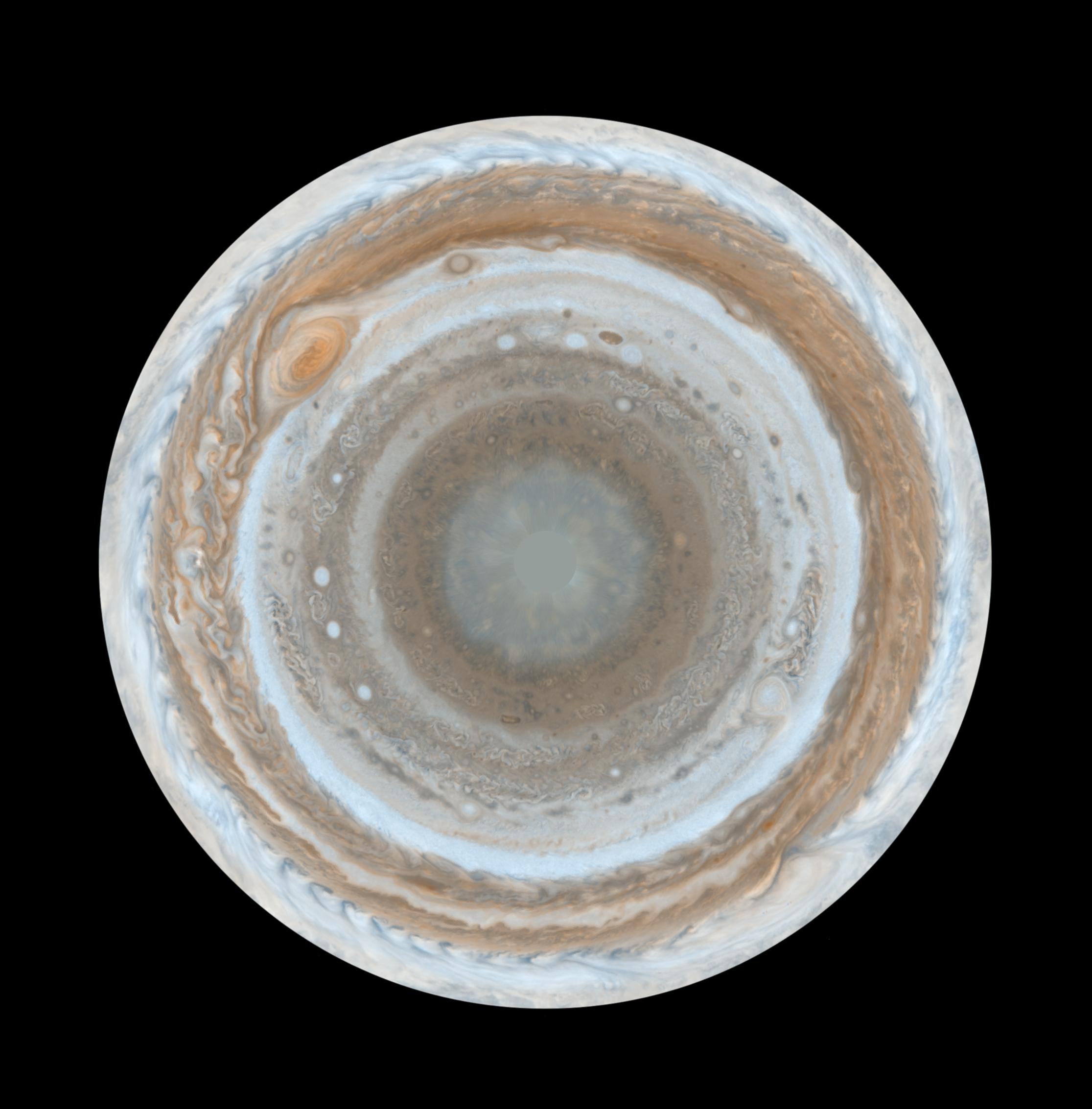
English: PIA07784: Cassini's Best Maps of Jupiter (South Polar Map) - These color maps of Jupiter were constructed from images taken by the narrow-angle camera onboard NASA's Cassini spacecraft on Dec. 11 and 12, 2000, as the spacecraft neared Jupiter during its flyby of the giant planet. Cassini was on its way to Saturn. They are the most detailed global color maps of Jupiter ever produced; the smallest visible features are about 120 kilometers (75 miles) across. For other maps see PIA07782 and PIA07783.
The maps are composed of 36 images: a pair of images covering Jupiter's northern and southern hemispheres was acquired in two colors every hour for nine hours as Jupiter rotated beneath the spacecraft. Although the raw images are in just two colors, 750 nanometers (near-infrared) and 451 nanometers (blue), the map's colors are close to those the human eye would see when gazing at Jupiter. The maps show a variety of colorful cloud features, including parallel reddish-brown and white bands, the Great Red Spot, multi-lobed chaotic regions, white ovals and many small vortices. Many clouds appear in streaks and waves due to continual stretching and folding by Jupiter's winds and turbulence. The bluish-gray features along the north edge of the central bright band are equatorial "hot spots," meteorological systems such as the one entered by NASA's Galileo probe. Small bright spots within the orange band north of the equator are lightning-bearing thunderstorms. The polar regions shown here are less clearly visible because Cassini viewed them at an angle and through thicker atmospheric haze. The round maps are polar stereographic projections that show the north or south pole in the center of the map and the equator at the edge. |
| Date | |
| Source | http://photojournal.jpl.nasa.gov/catalog/PIA07784 (image link) |
| Author | NASA/JPL/Space Science Institute |
This image or video was catalogued by Jet Propulsion Laboratory of the United States National Aeronautics and Space Administration (NASA) under Photo ID: PIA07784. This tag does not indicate the copyright status of the attached work. A normal copyright tag is still required. See Commons:Licensing. Other languages:
|
Licensing[edit]
_(5278071752).jpg&action=edit§ion=2)
| This file is in the public domain in the United States because it was solely created by NASA. NASA copyright policy states that "NASA material is not protected by copyright unless noted". (See Template:PD-USGov, NASA copyright policy page or JPL Image Use Policy.) | ||
 |
Warnings:
|
File history
Click on a date/time to view the file as it appeared at that time.
| Date/Time | Thumbnail | Dimensions | User | Comment | |
|---|---|---|---|---|---|
| current | 03:15, 31 December 2016 | | 2,231 × 2,266 (255 KB) | Huntster (talk | contribs) | Higher resolution from original source. |
| 07:07, 25 December 2015 |  | 500 × 508 (32 KB) | PlanetUser (talk | contribs) | Transferred from Flickr via Flickr2Commons |
You cannot overwrite this file.
File usage on Commons
The following page uses this file:
_(5278071752).jpg&oldid=849897980)