File:Cartogram of 2008-2020 US presidential elections.svg
Jump to navigation
Jump to search

Size of this PNG preview of this SVG file: 512 × 384 pixels. Other resolutions: 320 × 240 pixels | 640 × 480 pixels | 1,024 × 768 pixels | 1,280 × 960 pixels | 2,560 × 1,920 pixels.
Original file (SVG file, nominally 512 × 384 pixels, file size: 82 KB)
Captions
Captions
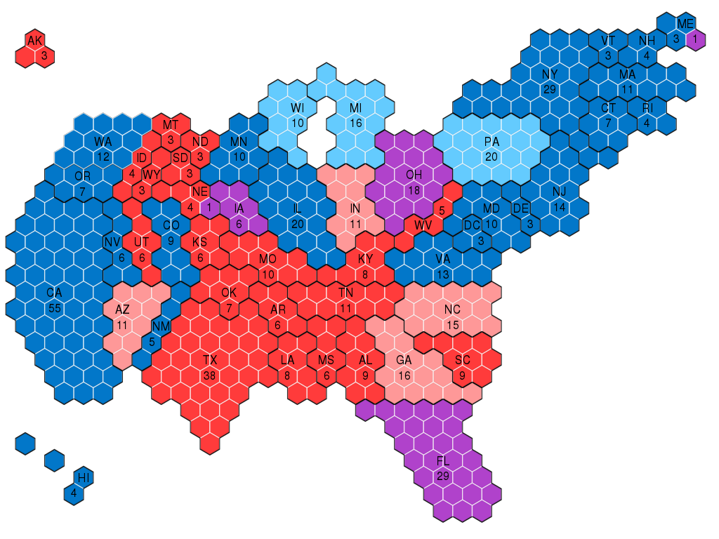
Cartogram of Electoral College results for last four US presidential elections (2008, 2012, 2016, and 2020).
Summary[edit]
| Description |
English: This hexagonal cartogram shows the winner of the Electoral College in each state for each of the last four US presidential elections (2008, 2012, 2016, and 2020).
Carried by the Republicans in all four elections
Carried by the Republicans in three of the four elections
Carried by each party twice in the four elections
Carried by the Democrats in three of the four elections
Carried by the Democrats in all four elections |
| Date | |
| Source | Own work |
| Author | DooplissForce |
Licensing[edit]
I, the copyright holder of this work, hereby publish it under the following license:
This file is licensed under the Creative Commons Attribution-Share Alike 4.0 International license.
- You are free:
- to share – to copy, distribute and transmit the work
- to remix – to adapt the work
- Under the following conditions:
- attribution – You must give appropriate credit, provide a link to the license, and indicate if changes were made. You may do so in any reasonable manner, but not in any way that suggests the licensor endorses you or your use.
- share alike – If you remix, transform, or build upon the material, you must distribute your contributions under the same or compatible license as the original.
File history
Click on a date/time to view the file as it appeared at that time.
| Date/Time | Thumbnail | Dimensions | User | Comment | |
|---|---|---|---|---|---|
| current | 13:16, 13 November 2022 | | 512 × 384 (82 KB) | Jamaika-Koalition (talk | contribs) | corrected Nebraska's 2nd congressional district |
| 17:12, 19 April 2022 |  | 512 × 384 (82 KB) | AlphaMikeOmega (talk | contribs) | w:Maine's 2nd congressional district | |
| 20:52, 12 May 2021 |  | 512 × 384 (82 KB) | DooplissForce (talk | contribs) | Reverted to version as of 20:46, 12 May 2021 (UTC) | |
| 20:51, 12 May 2021 |  | 512 × 384 (82 KB) | DooplissForce (talk | contribs) | Added back in label for Oregon (take 2) | |
| 20:46, 12 May 2021 |  | 512 × 384 (82 KB) | DooplissForce (talk | contribs) | Added back in label for Oregon | |
| 00:41, 9 February 2021 |  | 512 × 384 (82 KB) | DooplissForce (talk | contribs) | Uploaded own work with UploadWizard |
You cannot overwrite this file.
File usage on Commons
The following 6 pages use this file:
- User:Adeletron 3030/botgalleries/Sports/2021 May 11-13
- User:Adeletron 3030/botgalleries/Sports/2021 May 16/Overflow 1
- User:Magog the Ogre/Political maps/2021 February 1-9
- User:Magog the Ogre/Political maps/2021 May 11-20
- User:Magog the Ogre/Political maps/2022 April 11-20
- User:Magog the Ogre/Political maps/2022 November 11-20
File usage on other wikis
The following other wikis use this file:
- Usage on en.wikipedia.org
- Usage on ja.wikipedia.org