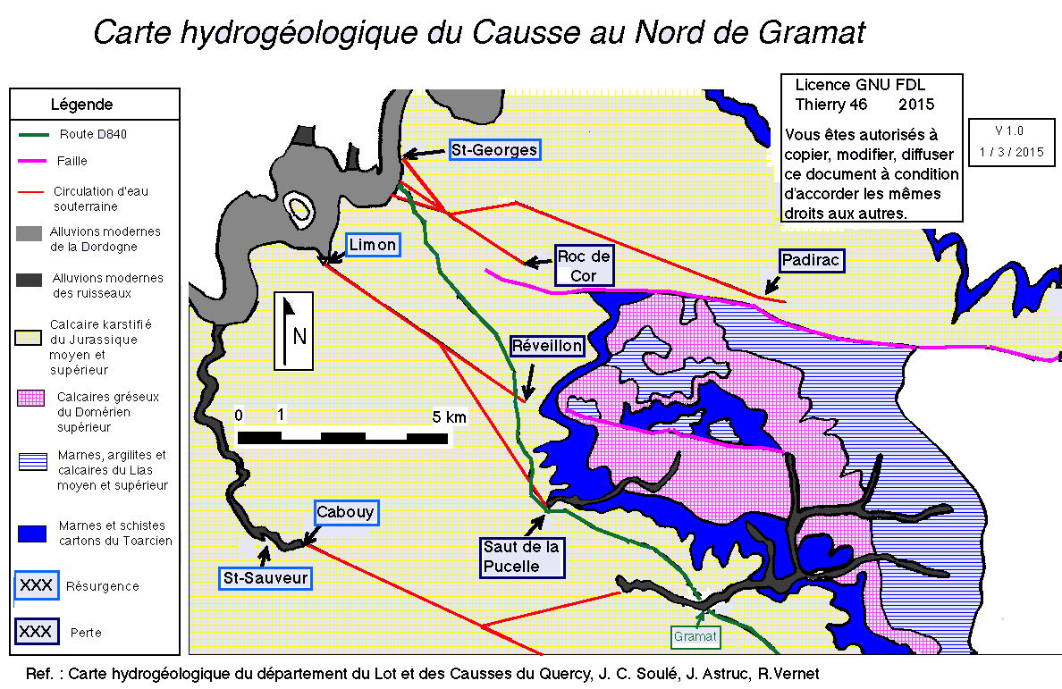
File:Carte hydrogeologique nord gramat.png
Jump to navigation
Jump to search
Size of this preview: 800 × 519 pixels. Other resolutions: 320 × 208 pixels | 640 × 415 pixels | 1,024 × 665 pixels | 1,188 × 771 pixels.
Original file (1,188 × 771 pixels, file size: 58 KB, MIME type: image/png)
Captions
Captions
Add a one-line explanation of what this file represents
Summary[edit]
| Description | |
| Date | |
| Source | Own work |
| Author | Thierry46 |
Licensing[edit]
I, the copyright holder of this work, hereby publish it under the following license:
This file is licensed under the Creative Commons Attribution-Share Alike 4.0 International license.
- You are free:
- to share – to copy, distribute and transmit the work
- to remix – to adapt the work
- Under the following conditions:
- attribution – You must give appropriate credit, provide a link to the license, and indicate if changes were made. You may do so in any reasonable manner, but not in any way that suggests the licensor endorses you or your use.
- share alike – If you remix, transform, or build upon the material, you must distribute your contributions under the same or compatible license as the original.
File history
Click on a date/time to view the file as it appeared at that time.
| Date/Time | Thumbnail | Dimensions | User | Comment | |
|---|---|---|---|---|---|
| current | 20:02, 1 March 2015 | | 1,188 × 771 (58 KB) | Thierry46 (talk | contribs) | User created page with UploadWizard |
You cannot overwrite this file.
File usage on Commons
There are no pages that use this file.
File usage on other wikis
The following other wikis use this file:
- Usage on fr.wikipedia.org
Metadata
Categories:
- Hydrogeological maps of France
- Gramat
- Gouffre de Padirac
- Gouffre du Saut de la Pucelle
- Gouffre de Réveillon
- Hydrology of France
- Geological maps of Lot
- Hydrogeology of France
- Hydrogeological maps of Alvignac
- Karst in Lot
- Ponors
- Resurgence (Hydrology)
- Jurassic geology of Lot
- Alluvium in Lot
- Karst hydrogeology of Lot (department)