File:Carte du cours du Rhône de Genève à Lyon - 1787.jpg

Original file (5,823 × 6,096 pixels, file size: 17.78 MB, MIME type: image/jpeg)
Captions
Captions
|
Summary[edit]
| Title |
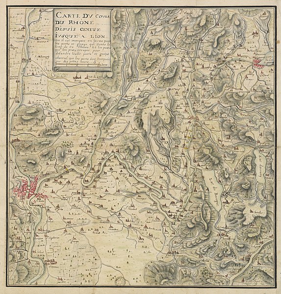
Carte du cours du Rhône depuis Genève jusque à Lion . Ou il est marqué en jaune tous les ports et guays qui sont le long de ce fleuve. Et les postes que l'on peut y occuper pour défendre lesdit ports et guays. Observé que les ports sont marqués par des petites ancre[s]. |
||||||||||||||||||||||||||
| DescriptionCarte du cours du Rhône de Genève à Lyon - 1787.jpg |
Français : Carte du cours du Rhône depuis Genève jusqu'à Lyon, où il est marqué en jaune tous les ports et guets qui sont le long de ce fleuve. Les postes que l'on peut y occuper pour défendre lesdits ports et guets. Observez que les ports sont marqués par des petites ancres.
English: Map of the Rhône river from Geneva up to Lyon, where ports and fords along the river are marked in yellow. Also included the posts which can be used to guard these ports and fords. See that the ports are shown by small anchors. |
||||||||||||||||||||||||||
| Date | |||||||||||||||||||||||||||
| Source |
Bibliothèque nationale de France
|
||||||||||||||||||||||||||
| Creator |
Unknown authorUnknown author |
||||||||||||||||||||||||||
| Georeferencing | Georeference the map in Wikimaps Warper If inappropriate please set warp_status = skip to hide. | ||||||||||||||||||||||||||
| Archival data | |||||||||||||||||||||||||||
| Collection |
institution QS:P195,Q193563 |
||||||||||||||||||||||||||
Licensing[edit]
| Public domainPublic domainfalsefalse |
|
This work is in the public domain in its country of origin and other countries and areas where the copyright term is the author's life plus 100 years or fewer. | |
| This file has been identified as being free of known restrictions under copyright law, including all related and neighboring rights. | |
https://creativecommons.org/publicdomain/mark/1.0/PDMCreative Commons Public Domain Mark 1.0falsefalse
| This file might NOT be in the public domain. It was previously considered to be in the public domain because it is a scan (or similar) by the Bibliotheque Nationale de France, but not everything scanned by the BNF is automatically in the public domain. It is possible that this file is in the public domain for other reasons, for example because it was published a long time ago (anything before ca. 1900 is most likely ok) or because its author / artist / photographer died over 70 years ago and it was published over 95 years ago. In such cases, a new rationale should be applied, and a different license tag (see Commons:Licensing and valid license tags at Commons:Copyright tags) should be used. If the file is not found to be in the public domain, it might be nominated for deletion (NOT by any automatic process, but manually). |
| Previous public domain rationale, no longer applicable | |||
|---|---|---|---|
|
File history
Click on a date/time to view the file as it appeared at that time.
| Date/Time | Thumbnail | Dimensions | User | Comment | |
|---|---|---|---|---|---|
| current | 07:55, 5 October 2018 |  | 5,823 × 6,096 (17.78 MB) | Yann (talk | contribs) | Cropped 4 % horizontally, 4 % vertically using CropTool with lossless mode. |
| 07:17, 20 March 2012 |  | 6,091 × 6,322 (16.07 MB) | Rexcornot (talk | contribs) | =={{int:filedesc}}== {{Artwork | artist = | title = Carte du cours du Rhône depuis Genève jusque 'a Lion . Ou il est marqué en jaune tous les ports et guays qui sont le long de ce fleuve. Et les postes que l'on peut y occuper ... |
You cannot overwrite this file.
File usage on Commons
The following 24 pages use this file:
- User:Eatcha/POTY-2018-Round-1-Results
- User:Yann/Featured images/2009-2018
- User:Yann/Featured pictures by others
- User:Zyephyrus/2018
- Commons:Featured picture candidates/File:Carte du cours du Rhône de Genève à Lyon - 1787.jpg
- Commons:Featured picture candidates/File:Carte du cours du Rhône de Genève à Lyon - 1787.jpg/2
- Commons:Featured picture candidates/Log/October 2018
- Commons:Featured picture candidates/Log/September 2015
- Commons:Featured pictures/Non-photographic media/Maps
- Commons:Featured pictures/chronological/2015-B
- Commons:Featured pictures/chronological/2018-B
- Commons:Picture of the Year/2015/Candidates
- Commons:Picture of the Year/2015/R1/Gallery/2014-B
- Commons:Picture of the Year/2015/R1/Gallery/2015-B
- Commons:Picture of the Year/2015/R1/Gallery/ALL
- Commons:Picture of the Year/2015/R1/Gallery/M09
- Commons:Picture of the Year/2015/R1/Gallery/Maps
- Commons:Picture of the Year/2015/R1/v/Carte du cours du Rhône de Genève à Lyon - 1787.jpg
- Commons:Picture of the Year/2018/Candidates
- Commons:Picture of the Year/2018/R1/Gallery/2018-B
- Commons:Picture of the Year/2018/R1/Gallery/ALL
- Commons:Picture of the Year/2018/R1/Gallery/M10
- Commons:Picture of the Year/2018/R1/Gallery/Maps
- Commons:Picture of the Year/2018/R1/v/Carte du cours du Rhône de Genève à Lyon - 1787.jpg
File usage on other wikis
The following other wikis use this file:
- Usage on frp.wikipedia.org
- Usage on fr.wikipedia.org
- Usage on uk.wikipedia.org
Metadata
This file contains additional information such as Exif metadata which may have been added by the digital camera, scanner, or software program used to create or digitize it. If the file has been modified from its original state, some details such as the timestamp may not fully reflect those of the original file. The timestamp is only as accurate as the clock in the camera, and it may be completely wrong.
| JPEG file comment | CREATOR: gd-jpeg v1.0 (using IJG JPEG v62), quality = 100 |
|---|
Structured data
image/jpeg
6392903bd9ffc17154b3a8794b9cba7070efefe5
18,646,470 byte
6,096 pixel
5,823 pixel
- Featured pictures on Wikimedia Commons
- Files from Gallica
- Template Unknown (author)
- CC-PD-Mark
- Author died more than 100 years ago public domain images
- Gallica scans
- Images from Gallica
- Images by JeanBono from Gallica
- Files uploaded by Yann Forget
- Featured pictures by others nominated by Yann Forget
- Featured maps
- Featured pictures of Lyon
- Featured pictures from Bibliothèque nationale de France

