File:Carte des villes américaines.svg
Jump to navigation
Jump to search

Size of this PNG preview of this SVG file: 800 × 522 pixels. Other resolutions: 320 × 209 pixels | 640 × 418 pixels | 1,024 × 669 pixels | 1,280 × 836 pixels | 2,560 × 1,672 pixels | 908 × 593 pixels.
Original file (SVG file, nominally 908 × 593 pixels, file size: 494 KB)
Captions
Captions
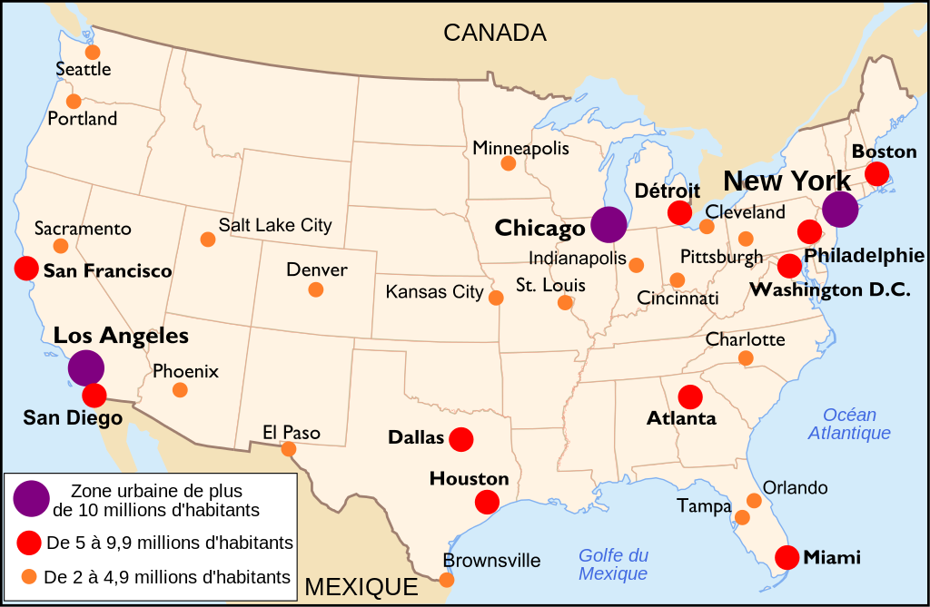
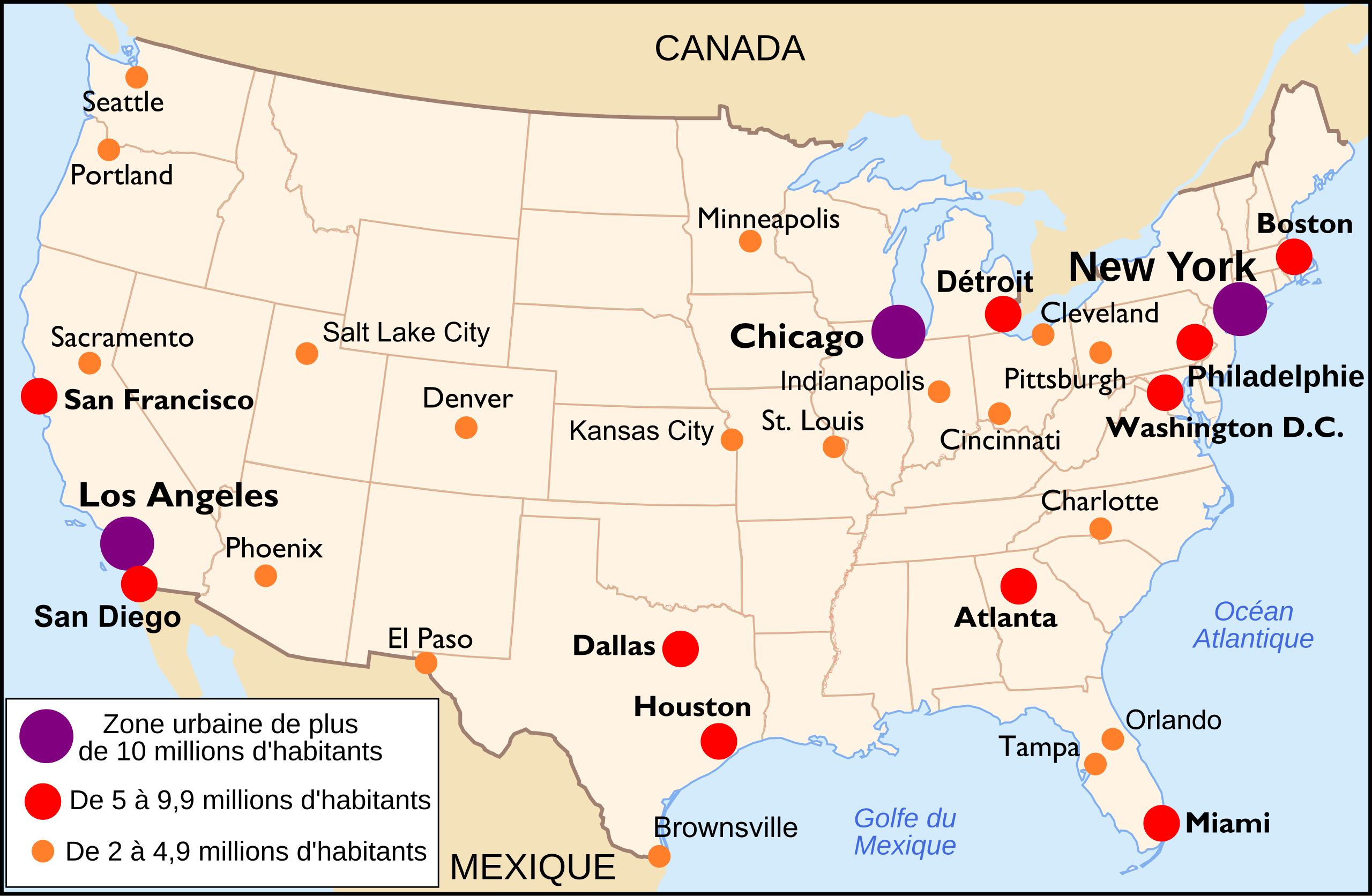
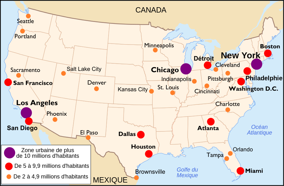
États-Unis
W3C-validity not checked.
| Description |
Français : Carte des villes américaines (Français) Español: Mapa de las principales áreas urbanas de Estados Unidos (Francés). English: Main US towns map (French) |
||||||||
| Date | |||||||||
| Source | http://commons.wikimedia.org/wiki/Image:Mapa_ciudades_USA.svg by Mortadelo2005 | ||||||||
| Author | historicair 20:27, 13 November 2006 (UTC) | ||||||||
| Permission (Reusing this file) |
I, the copyright holder of this work, hereby publish it under the following licenses:
This file is licensed under the Creative Commons Attribution-Share Alike 2.5 Generic, 2.0 Generic and 1.0 Generic license.
You may select the license of your choice. |
||||||||
| Other versions |
Derivative works of this file: |

File history
Click on a date/time to view the file as it appeared at that time.
| Date/Time | Thumbnail | Dimensions | User | Comment | |
|---|---|---|---|---|---|
| current | 14:16, 30 October 2010 | | 908 × 593 (494 KB) | Tachymètre (talk | contribs) | changed the oceans name's color to #4169E1, replaced the water's blue frame in the center of the map |
| 18:33, 28 February 2009 |  | 908 × 593 (491 KB) | Nakor (talk | contribs) | Update with data from http://www.populationdata.net/index2.php?option=pays&pid=64&nom=etats_unis | |
| 20:32, 13 November 2006 |  | 908 × 593 (454 KB) | Historicair (talk | contribs) | ||
| 20:27, 13 November 2006 |  | 908 × 593 (454 KB) | Historicair (talk | contribs) | {{Information |Description={{fr}}La bataille de Koh Chang (17 janvier 1941) {{en}}The Koh Chang battle (January 17th, 1941) |Source={{fr}}Carte des villes américaines {{es}}Mapa de las principales áreas urbanas de Estados Unidos. {{en}}Main US towns map |
You cannot overwrite this file.
File usage on Commons
The following page uses this file:
File usage on other wikis
The following other wikis use this file:
- Usage on eu.wikipedia.org
- Usage on fr.wikipedia.org
- Usage on ht.wikipedia.org
- Usage on hu.wikipedia.org
- Usage on incubator.wikimedia.org
- Usage on mg.wikipedia.org
- Usage on pcd.wikipedia.org
- Usage on pt.wikipedia.org