File:Carte des Khanats du Caucase-19emeS.png
Jump to navigation
Jump to search

Size of this preview: 800 × 582 pixels. Other resolutions: 320 × 233 pixels | 640 × 466 pixels | 1,024 × 745 pixels | 1,280 × 931 pixels | 2,560 × 1,862 pixels | 3,118 × 2,268 pixels.
Original file (3,118 × 2,268 pixels, file size: 426 KB, MIME type: image/png)
Captions
Captions
Add a one-line explanation of what this file represents
Summary[edit]
| Description |
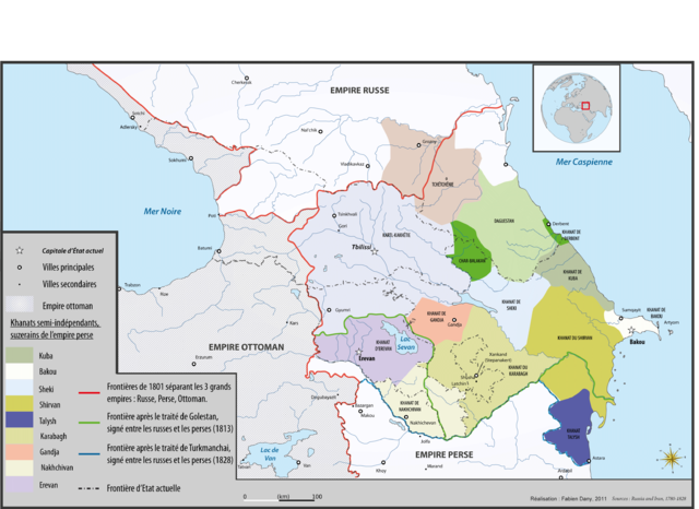
English: Map of caucasian khanates and struggle between persian and russian empire during the 19th century Français : Carte des Khanats du Caucase et de l'avancée russe dans le Caucase au XIXème siècle
|
| Date | |
| Source | Own work, originally published on http://www.liranpourlesnuls.net/cartes/carte-les-khanats-independants-du-caucase-avant-le-xviiieme-s/ |
| Author | Fabien Dany |
| Permission (Reusing this file) |
Français : L'utilisation est autorisée selon les termes ci-dessous et à condition de citer l'auteur et la source : www.liranpourlesnuls.net. Un email serait aussi grandement apprécié. |
| Other versions |
.png)
Licensing[edit]
I, the copyright holder of this work, hereby publish it under the following license:
This file is licensed under the Creative Commons Attribution-Share Alike 3.0 Unported license.
- You are free:
- to share – to copy, distribute and transmit the work
- to remix – to adapt the work
- Under the following conditions:
- attribution – You must give appropriate credit, provide a link to the license, and indicate if changes were made. You may do so in any reasonable manner, but not in any way that suggests the licensor endorses you or your use.
- share alike – If you remix, transform, or build upon the material, you must distribute your contributions under the same or compatible license as the original.
File history
Click on a date/time to view the file as it appeared at that time.
| Date/Time | Thumbnail | Dimensions | User | Comment | |
|---|---|---|---|---|---|
| current | 21:34, 27 January 2012 | | 3,118 × 2,268 (426 KB) | Fadany (talk | contribs) |
You cannot overwrite this file.
File usage on Commons
The following 2 pages use this file:
File usage on other wikis
The following other wikis use this file:
- Usage on de.wikipedia.org
- Usage on el.wikipedia.org
- Usage on es.wikipedia.org
- Usage on fr.wikipedia.org
- Usage on mt.wikipedia.org
- Usage on pl.wikipedia.org
Metadata
Categories:
- Maps of Khanates of the South Caucasus
- Maps of the history of Abkhazia
- PNG maps of the history of Azerbaijan
- Maps of the history of Naxçıvan
- Maps of the history of Kabardino-Balkaria
- Maps of the history of Karachay-Cherkessia
- Maps of the history of the south Caucasus region
- Maps of the history of Dagestan
- Maps of the history of Chechnya
- Maps of the history of Armenia
- Maps of the Caucasus by some users