File:Carte de la Barbarie de la Nigritie et de la Guinée (MAPS 88).jpg
Original file (7,583 × 5,918 pixels, file size: 8.79 MB, MIME type: image/jpeg)
Captions
Captions
|
|
|
This image was automatically transferred from the collections of the University of Washington. While certainly the majority of metadata in their database is correct, it is not necessarily written by individuals who are expert on the material they are describing. Such images often have incorrect dates, locations, or other information. If you can verify that this information is correct, or correct it if it isn't, please do so and remove this template. Also, if you are correcting information, please also let the library know so that they can update the metadata on their site. You can contact UW LIBRARIES MSCUA at photos |
Summary[edit]
| Title |
English: Carte de la Barbarie de la Nigritie et de la Guinée |
|||||||||||||||||||||||
| Description |
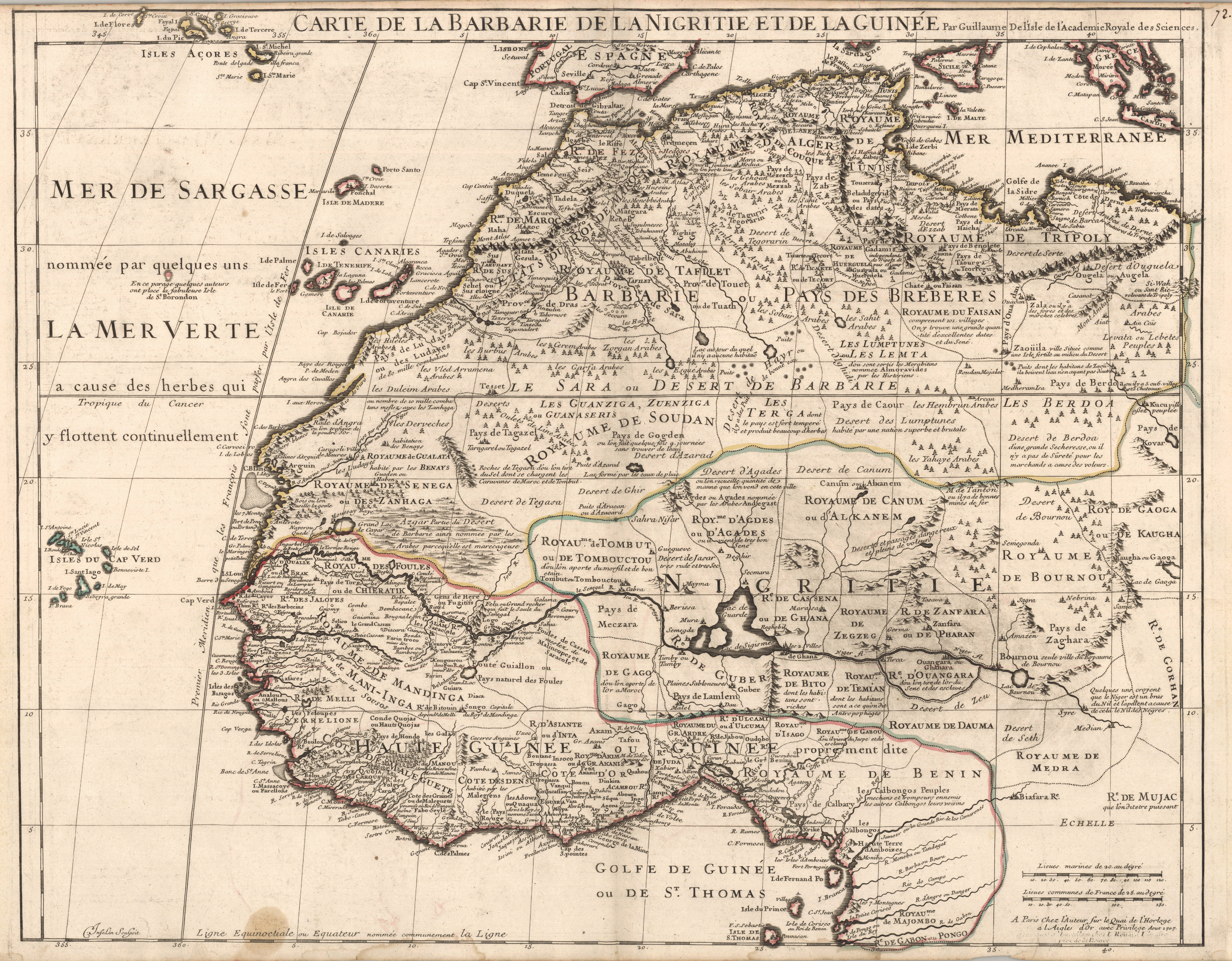
English: Copper engraving. Outline handcolored with watercolor. Relief shown pictorially. Printed in top border: "Carte De La Barbarie De La Nigritie Et De LA Guinée Par Guillaume De l'Isle de l'Academie Royale des Sciences." Printed in lower right corner is a scale comparing marine leagues and common French leagues. Printed in lower right corner beneath scale: "A Paris Chez l'Auteur sur le Quai de l'Horloge a l'Aigle d'Or avec Privilege Aout 1707." Printed in lower right corner beneath scale is previously engraved text that has been removed and is illegible. Printed in lower left corner along bottom border: "C. Inselin Sculpsit." Written in ink in upper right corner: "72." Depicts northern and western Africa including the Canary Islands, the Cape Verde Islands and the Azores. Shows the Niger River flowing east to west from Lac de Guarde. Various kingdoms and European settlements with commentary are also shown. The southern edge of Spain, Sicily, and Greece are visible in the north. Of note, shows Timbuktu as Tombouctou. Mountains, rivers, lakes and cities labeled with pictorial symbols. Prime Meridian: Ferro. Scale c.a. 1:9,200,000.Guillaume de L'Isle (1675-1726) was a cartographer and the Premier Geographer to the King in France beginning in 1718. His family played a significant part in the world of French cartography in the eighteenth century. At age 9, he drew his first map and at age 27 he became a member of the Académie Royale des Sciences. He studied under Jacques Cassini, acquiring knowledge in both mathematics and astronomy. Due to his academic background and his "critical approach to the maps of his predecessors," he became known as the first "scientific cartographer" (Moreland and Bannister, 132). Among his works are "Globe, map of the world and the four continents" (1700), "Atlas de Géographie" (1700-12), "Mississippi" (1701), "Carte du Mexique et de la Floride…" (c.a. 1703), "Carte de la Louisiane et du Mississippi" (1718) and posthumously, "Atlas Noveau" (1730 and later). Following his death, his widow, Marie Angélique de L'Isle took up the business with a partner, Philippe Buache (Tooley 395; Moreland and Bannister, 131-2). This particular map was first published in De L'Isle's "Atlas de Geographie." The map follows the geographic information known of this part of Africa current to the time period. Source(s): Moreland, Carl and David Bannister. "Antique Maps: A Collector's Handbook." New York: Longman Group, Ltd., 1983. Tooley, Ronald Vere. "Tooley's Dictionary of Mapmakers." Hertfordshire: Map Collector Publications Limited, 1979.
|
|||||||||||||||||||||||
| Publisher | L'Isle, Guillaume de 1675-1726 | |||||||||||||||||||||||
| Digital ID Number | MAP143 | |||||||||||||||||||||||
| Condition | Faint pink stains and brown stains along bottom edge in lower right. Light browning around edges. Has binder's guard. Water stains along bottom edge. | |||||||||||||||||||||||
| Date | ||||||||||||||||||||||||
| Source |
English: World and Regional Maps Collection |
|||||||||||||||||||||||
| Creator |
English: C. Inselin |
|||||||||||||||||||||||
| Permission (Reusing this file) |
|
|||||||||||||||||||||||
| Geotemporal data | ||||||||||||||||||||||||
| Map location |
English: Africa, West; Africa, North; |
|||||||||||||||||||||||
| Georeferencing | If inappropriate please set warp_status = skip to hide. | |||||||||||||||||||||||
| Bibliographic data | ||||||||||||||||||||||||
| Publication |
"Atlas de géographie." L'Isle, Guillaume de. Paris: Guillaume de L'Isle. |
|||||||||||||||||||||||
| Place of publication | Paris | |||||||||||||||||||||||
| Archival data | ||||||||||||||||||||||||
| Collection |
|
|||||||||||||||||||||||
| Accession number | ||||||||||||||||||||||||
| Dimensions | height: 50 cm (19.6 in); width: 61 cm (24 in) | |||||||||||||||||||||||


.jpg&action=edit§ion=1)
File history
Click on a date/time to view the file as it appeared at that time.
| Date/Time | Thumbnail | Dimensions | User | Comment | |
|---|---|---|---|---|---|
| current | 05:47, 8 July 2022 | | 7,583 × 5,918 (8.79 MB) | BMacZeroBot (talk | contribs) | Batch upload (Commons:Batch uploading/University of Washington Digital Collections) |
You cannot overwrite this file.
File usage on Commons
There are no pages that use this file.
.jpg&oldid=849207758)