File:Carte Topo Region Teheran.png
Jump to navigation
Jump to search

Size of this preview: 567 × 599 pixels. Other resolutions: 227 × 240 pixels | 454 × 480 pixels | 727 × 768 pixels | 969 × 1,024 pixels | 2,176 × 2,300 pixels.
Original file (2,176 × 2,300 pixels, file size: 3.89 MB, MIME type: image/png)
Captions
Captions
Add a one-line explanation of what this file represents
Summary[edit]
| Description |
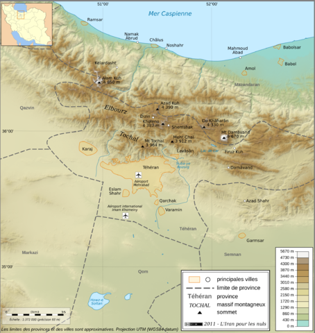
English: Topographic map in French of the Tehran area in Iran.
Note : The shaded relief is a raster image embedded in the SVG file. Français : Carte topographique en français de la région de fr:Téhéran (Iran). Note : Le relief ombré est une image bitmap embarquée dans le fichier SVG. UTM projection ; WGS84 datum ; shaded relief (composite image of N-W, W and N lightning positions) ;
|
| Date | |
| Source |
http://www.liranpourlesnuls.net/cartes/carte-teheran-et-sa-region/
|
| Author | Fabien Dany |
| Permission (Reusing this file) |
L'utilisation est autorisée selon les termes ci-dessous et à condition de citer comme source : L'Iran pour les nuls www.liranpourlesnuls.net. Un email serait aussi grandement apprécié. |
| Other versions |
 |
| Camera location | | View this and other nearby images on: OpenStreetMap |
|---|
Licensing[edit]
This file is licensed under the Creative Commons Attribution-Share Alike 3.0 Unported license.
- You are free:
- to share – to copy, distribute and transmit the work
- to remix – to adapt the work
- Under the following conditions:
- attribution – You must give appropriate credit, provide a link to the license, and indicate if changes were made. You may do so in any reasonable manner, but not in any way that suggests the licensor endorses you or your use.
- share alike – If you remix, transform, or build upon the material, you must distribute your contributions under the same or compatible license as the original.
This image has been assessed using the Quality image guidelines and is considered a Quality image.
|
File history
Click on a date/time to view the file as it appeared at that time.
| Date/Time | Thumbnail | Dimensions | User | Comment | |
|---|---|---|---|---|---|
| current | 22:11, 30 January 2011 | | 2,176 × 2,300 (3.89 MB) | Fabienkhan (talk | contribs) | {{Information |Description ={{en|1=Topographic map in French of the Tehran area in Iran.<br/>''Note :'' The shaded relief is a raster image embedded in the SVG file.}} {{fr|1=Carte topographique en français de la région de [[:fr:Téhé |
You cannot overwrite this file.
File usage on Commons
The following 4 pages use this file:
File usage on other wikis
The following other wikis use this file:
- Usage on ar.wikipedia.org
- Usage on ckb.wikipedia.org
- Usage on cs.wikipedia.org
- Usage on en.wikipedia.org
- Usage on fa.wikipedia.org
- Usage on fr.wikipedia.org
- Usage on incubator.wikimedia.org
- Usage on mg.wikipedia.org
- Usage on my.wikipedia.org
- Usage on vi.wikipedia.org
- Usage on www.wikidata.org