File:Carte Métro de Paris.svg
Jump to navigation
Jump to search

Size of this PNG preview of this SVG file: 800 × 562 pixels. Other resolutions: 320 × 225 pixels | 640 × 449 pixels | 1,024 × 719 pixels | 1,280 × 899 pixels | 2,560 × 1,797 pixels | 2,000 × 1,404 pixels.
Original file (SVG file, nominally 2,000 × 1,404 pixels, file size: 645 KB)
Captions
Captions
Add a one-line explanation of what this file represents
Summary[edit]
| Description |
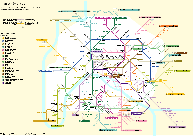
English: Network map of the Paris Métro
Français : Plan du métro de Paris |
| Date | |
| Source | Own work |
| Author | Rigil |
| Other versions | File:Carte Métro de Paris.jpg, File:Carte Metro de Paris raw.svg |
| SVG development |
Licensing[edit]
I, the copyright holder of this work, hereby publish it under the following licenses:

|
Permission is granted to copy, distribute and/or modify this document under the terms of the GNU Free Documentation License, Version 1.2 or any later version published by the Free Software Foundation; with no Invariant Sections, no Front-Cover Texts, and no Back-Cover Texts. A copy of the license is included in the section entitled GNU Free Documentation License. |
This file is licensed under the Creative Commons Attribution 3.0 Unported license.
- You are free:
- to share – to copy, distribute and transmit the work
- to remix – to adapt the work
- Under the following conditions:
- attribution – You must give appropriate credit, provide a link to the license, and indicate if changes were made. You may do so in any reasonable manner, but not in any way that suggests the licensor endorses you or your use.
You may select the license of your choice.
Assessment[edit]
|
File history
Click on a date/time to view the file as it appeared at that time.
| Date/Time | Thumbnail | Dimensions | User | Comment | |
|---|---|---|---|---|---|
| current | 16:27, 25 August 2016 | | 2,000 × 1,404 (645 KB) | Nvrandow (talk | contribs) | Added label for Bastille station |
| 20:22, 29 August 2015 |  | 2,000 × 1,404 (631 KB) | Terloup2 (talk | contribs) | Correction du nom de la station "Volontaires". Corrected a typo on "Volontaires" station name. | |
| 15:43, 1 November 2012 |  | 2,000 × 1,404 (631 KB) | Tiger66 (talk | contribs) | Optimisation du code, path text réécrits, réduction du poids. | |
| 20:26, 7 October 2012 |  | 2,000 × 1,397 (2.31 MB) | Tiger66 (talk | contribs) | Size reduction by replace text path by plain text. Delete somes unused definitions. | |
| 11:03, 12 July 2010 |  | 2,000 × 1,397 (2.92 MB) | Sameboat (talk | contribs) | remove large unknown, meaningless code and reduce the dimension to practical size. | |
| 00:34, 5 December 2009 |  | 7,529 × 5,258 (5.04 MB) | Gonioul (talk | contribs) | embedded image somewhere? | |
| 00:24, 5 December 2009 | No thumbnail | (4.92 MB) | Gonioul (talk | contribs) | test | |
| 16:05, 7 November 2009 |  | 7,530 × 5,259 (10.74 MB) | Rigil~commonswiki (talk | contribs) | Image jpg car impossible d'y arriver en svg... | |
| 15:50, 7 November 2009 | No thumbnail | (4.92 MB) | Rigil~commonswiki (talk | contribs) | Nouvelle version | |
| 15:44, 7 November 2009 | No thumbnail | (956 KB) | Rigil~commonswiki (talk | contribs) | {{Information |Description={{en|1=Network map of the Paris Métro}} {{fr|1=Plan du métro de Paris}} |Source={{own}} |Author=Rigil |Date=5 Novembre 2009 |Permission= |other_versions= }} Category:Paris Category:Public transport maps |
You cannot overwrite this file.
File usage on Commons
The following 15 pages use this file:
- List of Paris Metro lines
- List of stations of the Paris Metro
- Maps of Paris
- User:Chumwa/OgreBot/Potential transport maps/2016 August 21-31
- User:Chumwa/OgreBot/Public transport information/2015 August 21-31
- User:Chumwa/OgreBot/Public transport information/2016 August 21-31
- User:Chumwa/OgreBot/Transport Maps/2015 August 21-31
- User:Chumwa/OgreBot/Transport Maps/2016 August 21-31
- User:Chumwa/OgreBot/Travel and communication maps/2016 August 21-31
- User:Hoff1980/Rail transport in France/2015 August 21-31
- User:Paris 16/Paris
- Commons:Bistro/archives/février 2010
- File:Carte Metro de Paris raw.svg
- Category:Maps of Paris
- Category:Paris Metro
File usage on other wikis
The following other wikis use this file:
- Usage on af.wikipedia.org
- Usage on bs.wikipedia.org
- Usage on fa.wikipedia.org
- Usage on fr.wikipedia.org
- Usage on fr.wikinews.org
- Usage on he.wikivoyage.org
- Usage on ko.wikipedia.org
- Usage on lij.wikipedia.org
- Usage on mn.wikipedia.org
- Usage on nl.wikipedia.org
- Usage on ru.wikivoyage.org
- Usage on sv.wikipedia.org
- Usage on ug.wikipedia.org
- Usage on zh.wikipedia.org