File:Carte Lewis and Clark Expedition.png
Jump to navigation
Jump to search
Size of this preview: 800 × 520 pixels. Other resolutions: 320 × 208 pixels | 640 × 416 pixels | 1,024 × 665 pixels | 1,513 × 983 pixels.
Original file (1,513 × 983 pixels, file size: 84 KB, MIME type: image/png)
Captions
Captions
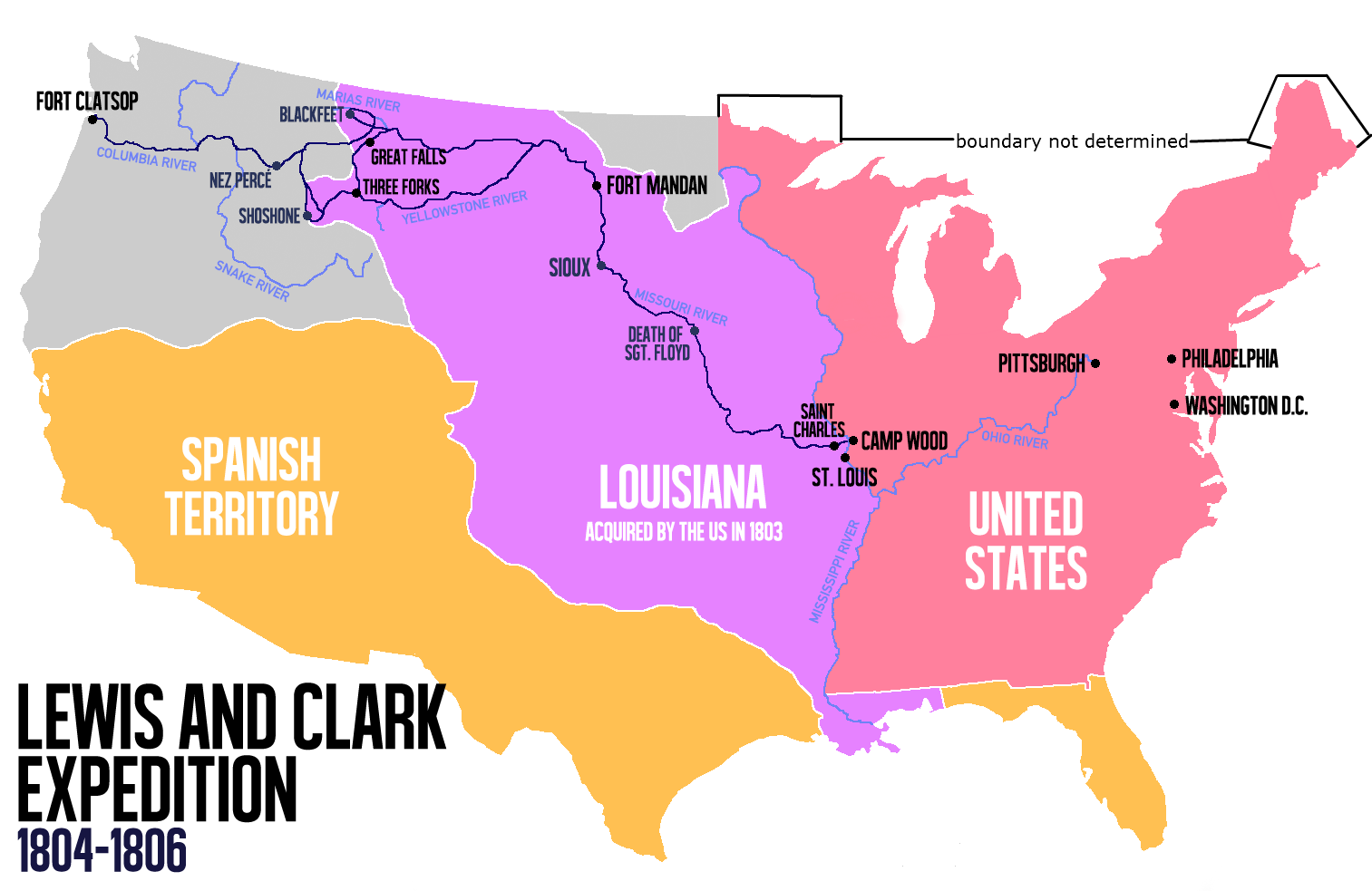
Route of the Lewis and Clark expedition

|
This historical map image could be re-created using vector graphics as an SVG file. This has several advantages; see Commons:Media for cleanup for more information. If an SVG form of this image is available, please upload it and afterwards replace this template with
{{vector version available|new image name}}.
It is recommended to name the SVG file “Carte Lewis and Clark Expedition.svg”—then the template Vector version available (or Vva) does not need the new image name parameter. |
Summary[edit]
| Description |
English: Route of the Lewis and Clark Expedition |
| Date | |
| Source |
Own work, This file was derived from: Carte Lewis-Clark Expedition-en.png |
| Author | Victor van Werkhooven |
| Other versions |
 |
Licensing[edit]
| I, the copyright holder of this work, release this work into the public domain. This applies worldwide. In some countries this may not be legally possible; if so: I grant anyone the right to use this work for any purpose, without any conditions, unless such conditions are required by law. |
File history
Click on a date/time to view the file as it appeared at that time.
| Date/Time | Thumbnail | Dimensions | User | Comment | |
|---|---|---|---|---|---|
| current | 14:21, 13 June 2014 | | 1,513 × 983 (84 KB) | Nwbeeson (talk | contribs) | Reverted to version as of 14:18, 13 June 2014 |
| 14:20, 13 June 2014 |  | 1,513 × 983 (84 KB) | Nwbeeson (talk | contribs) | Corrected boundary of the United States. The original left out Maine, Michigan, Wisconsin, and part of Minnesota, none of which were states, but all of which were definitely part of the territory of the United States. | |
| 14:18, 13 June 2014 |  | 1,513 × 983 (84 KB) | Nwbeeson (talk | contribs) | Corrected boundary of the United States. The original left out Maine, Michigan, Wisconsin, and part of Minnesota, none of which were states, but all of which were definitely part of the territory of the United States. | |
| 15:17, 22 May 2014 |  | 1,513 × 983 (134 KB) | Luctor (talk | contribs) | User created page with UploadWizard |
You cannot overwrite this file.
File usage on Commons
The following 3 pages use this file:
File usage on other wikis
The following other wikis use this file:
- Usage on ast.wikipedia.org
- Usage on bn.wikipedia.org
- Usage on de.wikipedia.org
- Usage on en.wikipedia.org
- Usage on es.wikipedia.org
- Usage on et.wikipedia.org
- Usage on eu.wikipedia.org
- Usage on fa.wikipedia.org
- Usage on gl.wikipedia.org
- Usage on hu.wikipedia.org
- Usage on it.wikipedia.org
- Usage on ko.wikipedia.org
- Usage on ms.wikipedia.org
- Usage on nl.wikipedia.org
- Usage on no.wikipedia.org
- Usage on oc.wikipedia.org
- Usage on pl.wikipedia.org
- Usage on sr.wikipedia.org
- Usage on tr.wikipedia.org
- Usage on www.wikidata.org
- Usage on zh.wikipedia.org