File:Carte Bougainville détail Lanciers-Facardins 1768.jpg
Jump to navigation
Jump to search
No higher resolution available.
Carte_Bougainville_détail_Lanciers-Facardins_1768.jpg (308 × 203 pixels, file size: 26 KB, MIME type: image/jpeg)
Captions
Captions
Add a one-line explanation of what this file represents
Summary
[edit]
| Description |
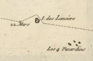
English: Détail de la carte des Tuamotu établie par Louis Antoine de Bougainville en 1768 (Première division, archipel dangereux, terres basses et noyées). Apparaissent Les Quatre Facardins (actuel Vahitahi) et l'île des Lanciers (actuel Akiaki) |
||||
| Date | |||||
| Source | File:Carte_Bougainville_aux_Tuamotus_1768.jpg | ||||
| Author | Louis Antoine de Bougainville (1729-1811) | ||||
| Permission (Reusing this file) |
|
Licensing
[edit]
|
This work is in the public domain in its country of origin and other countries and areas where the copyright term is the author's life plus 100 years or fewer. | |
| This file has been identified as being free of known restrictions under copyright law, including all related and neighboring rights. | |
File history
Click on a date/time to view the file as it appeared at that time.
| Date/Time | Thumbnail | Dimensions | User | Comment | |
|---|---|---|---|---|---|
| current | 01:46, 17 October 2013 | | 308 × 203 (26 KB) | LPLT (talk | contribs) | {{Information |Description ={{en|1=Détail de la carte des Tuamotu établie par Louis Antoine de Bougainville en 1768 (Première division, archipel dangereux, terres basses et noyées). Apparaissent Les Quatre Facardins (actuel Vahitahi) et l'île d... |
You cannot overwrite this file.
File usage on Commons
There are no pages that use this file.
File usage on other wikis
The following other wikis use this file: