File:Carte-ORTF de.svg
Jump to navigation
Jump to search

Size of this PNG preview of this SVG file: 765 × 600 pixels. Other resolutions: 306 × 240 pixels | 612 × 480 pixels | 980 × 768 pixels | 1,280 × 1,004 pixels | 2,560 × 2,007 pixels | 875 × 686 pixels.
Original file (SVG file, nominally 875 × 686 pixels, file size: 211 KB)
Captions
Captions
Add a one-line explanation of what this file represents
Summary[edit]
| Description |
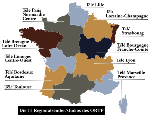
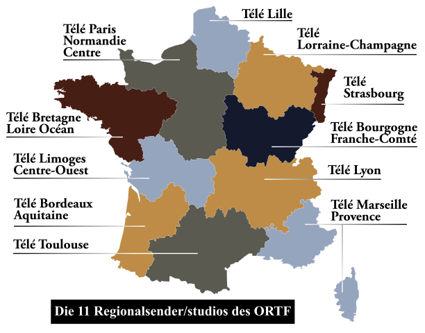
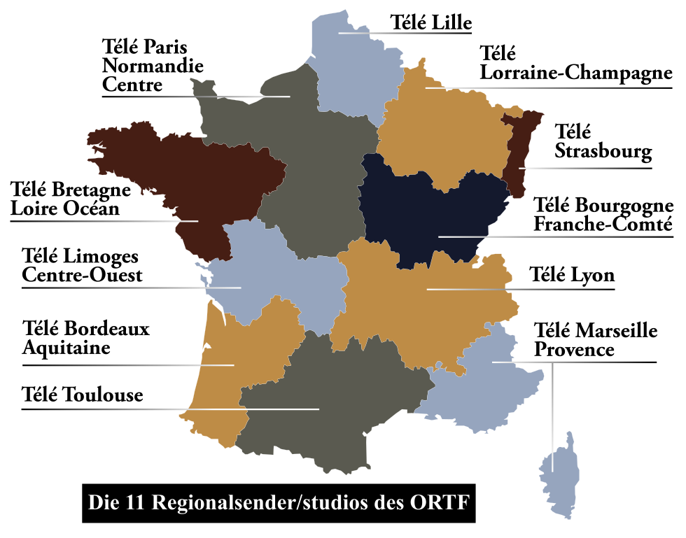
Deutsch: Karte der regionalen Kanäle des ORTF
Français : Carte des stations régionales de l'ORTF
English: Map of regional channels of the ORTF |
| Date | (UTC) |
| Source |
This file was derived from: Carte-ORTF.svg: |
| Author |
|
| This is a retouched picture, which means that it has been digitally altered from its original version. Modifications: traduction allemand/deutsche Übersetzung. The original can be viewed here: Carte-ORTF.svg:
|
Licensing[edit]
I, the copyright holder of this work, hereby publish it under the following license:
| This file is made available under the Creative Commons CC0 1.0 Universal Public Domain Dedication. | |
| The person who associated a work with this deed has dedicated the work to the public domain by waiving all of their rights to the work worldwide under copyright law, including all related and neighboring rights, to the extent allowed by law. You can copy, modify, distribute and perform the work, even for commercial purposes, all without asking permission.
|
Original upload log[edit]
This image is a derivative work of the following images:
- File:Carte-ORTF.svg licensed with Cc-zero
- 2011-10-14T07:06:55Z Daisy0705 846x656 (207994 Bytes) Je continue à résoudre les erreurs
- 2011-10-14T07:05:28Z Daisy0705 860x670 (186662 Bytes) Correction d'erreur
- 2011-10-14T07:04:57Z Daisy0705 900x700 (208209 Bytes) Reverted to version as of 07:00, 14 October 2011
- 2011-10-14T07:03:21Z Daisy0705 880x690 (212256 Bytes) Augmentation contour régions
- 2011-10-14T07:00:59Z Daisy0705 846x685 (212276 Bytes) Couleurs pour plus de lisibilité
- 2011-10-14T07:00:27Z Daisy0705 900x700 (208209 Bytes) Reverted to version as of 12:12, 8 August 2011
- 2011-10-14T06:58:49Z Daisy0705 846x656 (208703 Bytes) Correction d'une erreur de typo
- 2011-10-14T06:57:43Z Daisy0705 846x656 (186946 Bytes) Ajout de couleurs, toujours pour améliorer la lisibilité
- 2011-08-08T12:12:43Z Daisy0705 900x700 (208209 Bytes) Agrandissement des limites des régions pour plus de lisibilité
- 2011-08-08T12:08:11Z Daisy0705 900x700 (207985 Bytes) {{Information |Description ={{en|1=Map of regional channels of the ORTF}} {{fr|1=Carte des stations régionales de l'ORTF}} |Source =Création personnelle |Author =Daisy0705 |Date =08/08/2011 |Per
Uploaded with derivativeFX
File history
Click on a date/time to view the file as it appeared at that time.
| Date/Time | Thumbnail | Dimensions | User | Comment | |
|---|---|---|---|---|---|
| current | 19:46, 5 May 2012 | | 875 × 686 (211 KB) | Furfur (talk | contribs) | == {{int:filedesc}} == {{Information |Description={{de|1=Karte der regionalen Kanäle des ORTF}} {{fr|1=Carte des stations régionales de l'ORTF}} {{en|1=Map of regional channels of the ORTF}} |Source={{Derived from|Carte-ORTF.svg|display=50}} |Date=20... |
You cannot overwrite this file.
File usage on Commons
There are no pages that use this file.
File usage on other wikis
The following other wikis use this file:
- Usage on de.wikipedia.org
- Usage on en.wikipedia.org