File:Carretera al monasterio Noravank, Armenia, 2016-10-01, DD 55-59 PAN.jpg

Original file (16,083 × 5,037 pixels, file size: 17.06 MB, MIME type: image/jpeg)
Captions
Captions
Summary[edit]
| Warning | The original file is very high-resolution. It might not load properly or could cause your browser to freeze when opened at full size. |
|---|
| Description |
Español: Vista panorámica del punto de fuga de la carretera que atraviesa el valle Amaghu, cerca del monasterio Noravank del siglo XIII, Armenia. El estrecho cañón, situado junto a la localidad de Yeghegnadzor y a 122 km de la capital, Ereván, fue erosionado por el río Amaghu.
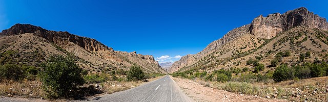
English: Panoramic view of the vanishing road through the Amaghu valley near the 13th-century monastery of Noravank, Armenia. The narrow gorge, located near Yeghegnadzor and 122 kilometres (76 mi) from the capital, Yerevan, was eroded by the Amaghu River.
Polski: Panorama znikającej drogi przebiegającej przez dolinę Amaghu, w pobliżu XIII-wiecznego klasztoru Norawank w Armenii. Wąski wąwóz, położony niedaleko miasta Jeghegnadzor i 122 km od Erywania, stolicy Armenii, został wyżłobiony przez rzekę Amaghu.
Čeština: Panoramatický pohled na silnici vedoucí údolím Amaghu poblíž arménského kláštera Noravank ze 13. století.
Italiano: Vista della strada che attraversa la valle di Amaghu, vicino al monastero del XIII secolo di Noravank, in Armenia. Lo stretto burrone, situato vicino alla località di Yeghegnadzor e a 122 km dalla capitale Yerevan, è stato eroso dal fiume Amaghu.
Македонски: Широк поглед на патот низ долината Амаху близу градот Ехегнаѕор, Ерменија.
Nederlands: Weg door de Amaghuvallei in de buurt van de Armeense stad Jechegnadzor
Português: Vista panorâmica da estrada que atravessa o vale Amaghu, perto do mosteiro de Noravank, Armênia. |
||||||||||||||||||||
| Date | |||||||||||||||||||||
| Source | Own work | ||||||||||||||||||||
| Author |
|
||||||||||||||||||||

Assessment[edit]
|
This image was selected as picture of the day on Wikimedia Commons for 26 September 2018. It was captioned as follows: English: Panoramic view of the vanishing road through the Amaghu valley near the 13th-century monastery of Noravank, Armenia. The narrow gorge, located near Yeghegnadzor and 122 kilometres (76 mi) from the capital, Yerevan, was eroded by the Amaghu River. Other languages:
Čeština: Panoramatický pohled na silnici vedoucí údolím Amaghu poblíž arménského kláštera Noravank ze 13. století. English: Panoramic view of the vanishing road through the Amaghu valley near the 13th-century monastery of Noravank, Armenia. The narrow gorge, located near Yeghegnadzor and 122 kilometres (76 mi) from the capital, Yerevan, was eroded by the Amaghu River. Español: Vista panorámica del punto de fuga de la carretera que atraviesa el valle Amaghu, cerca del monasterio Noravank del siglo XIII, Armenia. El estrecho cañón, situado junto a la localidad de Yeghegnadzor y a 122 km de la capital, Ereván, fue erosionado por el río Amaghu. Italiano: Vista della strada che attraversa la valle di Amaghu, vicino al monastero del XIII secolo di Noravank, in Armenia. Lo stretto burrone, situato vicino alla località di Yeghegnadzor e a 122 km dalla capitale Yerevan, è stato eroso dal fiume Amaghu. Nederlands: Weg door de Amaghuvallei in de buurt van de Armeense stad Jechegnadzor Polski: Panorama znikającej drogi przebiegającej przez dolinę Amaghu, w pobliżu XIII-wiecznego klasztoru Norawank w Armenii. Wąski wąwóz, położony niedaleko miasta Jeghegnadzor i 122 km od Erywania, stolicy Armenii, został wyżłobiony przez rzekę Amaghu. Português: Vista panorâmica da estrada que atravessa o vale Amaghu, perto do mosteiro de Noravank, Armênia. Македонски: Широк поглед на патот низ долината Амаху близу градот Ехегнаѕор, Ерменија. |
Licensing[edit]
Another one of my pictures: Want to see more works of mine? click here |
Under this condition:
Please, use this work legally fulfilling the terms of the license! Please, let me know if you use this work outside Wikimedia Commons sending me an email on Furthermore, if you:
please, do not hesitate to contact me. |

|
Please do not overwrite the author's version with a modified image without discussing with the author. The author would like to make corrections only from the uncompressed RAW file. This ensures that changes are preserved and are based on the best possible source to achieve a high quality. If you think that changes are required, please, get in touch with the author. Otherwise, you can upload a new image with a different name without overwriting this one. Use {{Derived from}} or {{Extracted from}} for this purpose. |
- You are free:
- to share – to copy, distribute and transmit the work
- to remix – to adapt the work
- Under the following conditions:
- attribution – You must give appropriate credit, provide a link to the license, and indicate if changes were made. You may do so in any reasonable manner, but not in any way that suggests the licensor endorses you or your use.
- share alike – If you remix, transform, or build upon the material, you must distribute your contributions under the same or compatible license as the original.
File history
Click on a date/time to view the file as it appeared at that time.
| Date/Time | Thumbnail | Dimensions | User | Comment | |
|---|---|---|---|---|---|
| current | 11:21, 25 June 2017 | 16,083 × 5,037 (17.06 MB) | Poco a poco (talk | contribs) | Better finishin of edges | |
| 11:03, 25 June 2017 | 16,083 × 5,037 (17.23 MB) | Poco a poco (talk | contribs) | Sky banding | ||
| 17:09, 24 June 2017 | 16,083 × 5,037 (21.12 MB) | Poco a poco (talk | contribs) | Sky artifacts | ||
| 12:50, 23 October 2016 | 16,083 × 5,037 (10.51 MB) | Poco a poco (talk | contribs) | User created page with UploadWizard |
You cannot overwrite this file.
File usage on Commons
The following 32 pages use this file:
- User:Kareyac/Armenia/2016 October 21-31
- User:Kareyac/Armenia/2017 June 21-30
- User:Poco a poco/Armenia
- User:Poco a poco/Panoramas
- User:Poco a poco/Transport
- User:Trödel/Pictures of the Day
- User talk:Poco a poco/2017-07
- User talk:Poco a poco/2017-08
- Commons:Featured picture candidates/File:Carretera al monasterio Noravank, Armenia, 2016-10-01, DD 55-59 PAN.jpg
- Commons:Featured picture candidates/Log/July 2017
- Commons:Featured pictures/Places/Other
- Commons:Featured pictures/chronological/2017-B
- Commons:Picture of the Year/2017/Candidates
- Commons:Picture of the Year/2017/R1/Gallery/2017-B
- Commons:Picture of the Year/2017/R1/Gallery/ALL
- Commons:Picture of the Year/2017/R1/Gallery/M07
- Commons:Picture of the Year/2017/R1/Gallery/Panoramic views
- Commons:Picture of the Year/2017/R1/v/Carretera al monasterio Noravank, Armenia, 2016-10-01, DD 55-59 PAN.jpg
- Commons:Quality images/Subject/Places/Natural structures/archive 2017
- Commons:Quality images candidates/Archives August 26 2017
- Template:Potd/2018-09
- Template:Potd/2018-09-26
- Template:Potd/2018-09-26 (cs)
- Template:Potd/2018-09-26 (en)
- Template:Potd/2018-09-26 (es)
- Template:Potd/2018-09-26 (hu)
- Template:Potd/2018-09-26 (it)
- Template:Potd/2018-09-26 (mk)
- Template:Potd/2018-09-26 (nl)
- Template:Potd/2018-09-26 (pl)
- Template:Potd/2018-09-26 (pt)
- Template:Potd/2018-09-26 (pt-br)
File usage on other wikis
The following other wikis use this file:
- Usage on be-tarask.wikipedia.org
- Usage on crh.wikipedia.org
- Usage on cv.wikipedia.org
- Usage on fa.wikipedia.org
- Usage on fr.wikipedia.org
- Usage on hu.wikipedia.org
- Usage on hy.wikipedia.org
- Usage on ka.wikipedia.org
- Usage on ko.wikipedia.org
- Usage on lbe.wikipedia.org
- Usage on lez.wikipedia.org
- Usage on mk.wikipedia.org
- Usage on nl.wikipedia.org
- Usage on os.wikipedia.org
- Usage on pt.wikipedia.org
- Usage on ru.wikipedia.org
- Usage on ru.wikinews.org
- Usage on sah.wikipedia.org
- Usage on tt.wikipedia.org
- Usage on vep.wikipedia.org
- Usage on zh.wikipedia.org