File:Carretera Austral.png
Jump to navigation
Jump to search

Size of this preview: 308 × 598 pixels. Other resolutions: 123 × 240 pixels | 247 × 480 pixels | 395 × 768 pixels | 1,100 × 2,136 pixels.
Original file (1,100 × 2,136 pixels, file size: 884 KB, MIME type: image/png)
Captions
Captions
Add a one-line explanation of what this file represents

|
This map image could be re-created using vector graphics as an SVG file. This has several advantages; see Commons:Media for cleanup for more information. If an SVG form of this image is available, please upload it and afterwards replace this template with
{{vector version available|new image name}}.
It is recommended to name the SVG file “Carretera Austral.svg”—then the template Vector version available (or Vva) does not need the new image name parameter. |
Summary[edit]
| Description |
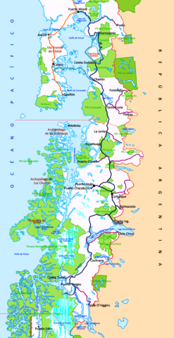
Afrikaans: Kaart van die Carretera Austral (amptelik Ruta CH-7), 'n (in 2022 nog onvoltooide) pad van sowat 1 350 km in Chile, wat by Puerto Montt begin en suidwaarts loop na Villa O’Higgins aan die suidgrens van Región de Aysén.
English: Map of the Carretera Austral, in Chile. |
| Date | |
| Source | Dibujo propio basado en diferentes mapas |
| Author | User:B1mbo |
| Permission (Reusing this file) |
Doble licencia GFDL y CC-BY-SA-2.5 |
Leyenda / Legend[edit]
NOTE: The above map and the following key do not accurately reflect the Carretera Austral conditions with respect to sections which are now paved (asphalted).
Parques nacionales, Reservas nacionales (National parks, National reserves)
| Límite internacional (International limit) |
| Límite regional (Regional limit) |
- Carreteras (Highways)
| Carretera Panamericana (Pan-American Highway) |
| Carretera Austral pavimentada (Paved Carretera Austral) |
| Carretera Austral no pavimentada (Unpaved Carretera Austral) |
| Ramales de la Carretera Austral no pavimentados (Unpaved branches of Carretera Austral) |
| En construcción (Under construction) |
| Proyectado (Projected) |
| Transbordador (Ferry) |
Licensing[edit]
I, the copyright holder of this work, hereby publish it under the following licenses:

|
Permission is granted to copy, distribute and/or modify this document under the terms of the GNU Free Documentation License, Version 1.2 or any later version published by the Free Software Foundation; with no Invariant Sections, no Front-Cover Texts, and no Back-Cover Texts. A copy of the license is included in the section entitled GNU Free Documentation License. |
| This file is licensed under the Creative Commons Attribution-Share Alike 3.0 Unported license. | ||
| ||
| This licensing tag was added to this file as part of the GFDL licensing update. |
This file is licensed under the Creative Commons Attribution-Share Alike 2.5 Generic, 2.0 Generic and 1.0 Generic license.
- You are free:
- to share – to copy, distribute and transmit the work
- to remix – to adapt the work
- Under the following conditions:
- attribution – You must give appropriate credit, provide a link to the license, and indicate if changes were made. You may do so in any reasonable manner, but not in any way that suggests the licensor endorses you or your use.
- share alike – If you remix, transform, or build upon the material, you must distribute your contributions under the same or compatible license as the original.
You may select the license of your choice.
File history
Click on a date/time to view the file as it appeared at that time.
| Date/Time | Thumbnail | Dimensions | User | Comment | |
|---|---|---|---|---|---|
| current | 16:06, 29 November 2022 | | 1,100 × 2,136 (884 KB) | JMK (talk | contribs) | adjust colour balance, midtones and add contrast |
| 16:00, 18 January 2016 |  | 1,100 × 2,136 (1.12 MB) | SteinsplitterBot (talk | contribs) | Bot: Image rotated by 270° | |
| 21:00, 9 December 2015 |  | 2,136 × 1,100 (1.11 MB) | SteinsplitterBot (talk | contribs) | Bot: Image rotated by 90° | |
| 02:30, 12 October 2006 |  | 1,100 × 2,136 (1.11 MB) | B1mbo (talk | contribs) | {{Information |Description={{es|Mapa de la Carretera Austral, en Chile}}{{en|Map of the Carretera Austral, at Chile. |Source=Dibujo propio basado en diferentes mapas |Date=11 de octubre de 2006 |Auth |
You cannot overwrite this file.
File usage on Commons
The following 3 pages use this file:
File usage on other wikis
The following other wikis use this file:
- Usage on cs.wikipedia.org
- Usage on de.wikipedia.org
- Usage on de.wikivoyage.org
- Usage on en.wikipedia.org
- Usage on es.wikipedia.org
- Usage on eu.wikipedia.org
- Usage on fr.wikipedia.org
- Usage on he.wikipedia.org
- Usage on it.wikipedia.org
- Usage on ka.wikipedia.org
- Usage on lt.wikipedia.org
- Usage on pl.wikipedia.org
- Usage on pt.wikipedia.org
- Usage on sl.wikipedia.org
- Usage on sv.wikipedia.org
- Usage on www.wikidata.org
Metadata
Categories:
- Carretera Austral
- Patagonia, Chile
- Maps of Chiloé Island
- Alerce Andino National Park
- Bernardo O'Higgins National Park
- Cerro Castillo National Park
- Chiloé National Park
- Chonos Archipelago
- Corcovado National Park (Chile)
- Hornopirén National Park
- Isla Magdalena National Park
- Lago Cochrane Nature Reserve
- Lago Jeinimeni Nature Reserve
- Lago Puelo National Park
- Laguna San Rafael National Park
- Llanquihue Nature Reserve
- Los Alerces National Park
- Spanish-language maps
- Maps of Aysén Region
- Maps of Los Lagos Region
- Maps of Patagonia
- National parks of Argentina
- National parks of Patagonia
- Patagonia, Argentina
- Perito Moreno National Park
- Private nature reserves in Chile
- Pumalín National Park
- Queulat National Park
- Taitao Peninsula
- Tantauco Park