File:Capdepera Son Jaumell SW.jpg
Original file (5,905 × 3,936 pixels, file size: 4.23 MB, MIME type: image/jpeg)
Captions
Summary[edit]
DescriptionCapdepera Son Jaumell SW.jpg |
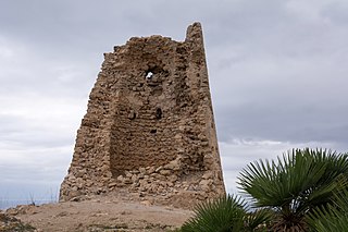
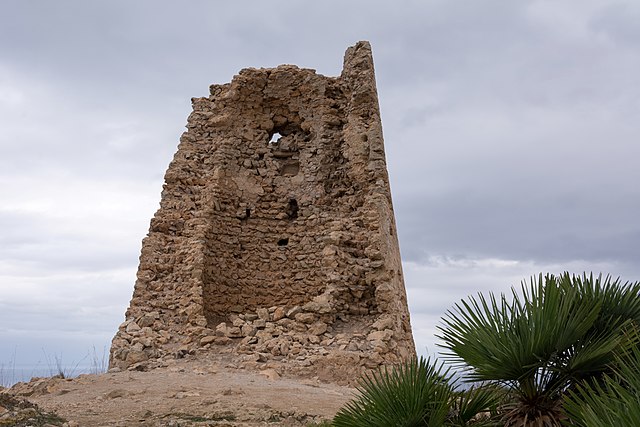
Català: Son Jaumell (Capdepera) Deutsch: Talaia de Son Jaumell (Capdepera), die Ruine eines Wachturms auf dem Gipfel des Es Telégraf (273 m) English: Talaia de Son Jaumell (Capdepera), the remains of a watchtower on the top of Es Telégraf (273 m)
|
||
Date | |||
Source | Own work | ||
Author | Isiwal |
Camera location | 39° 44′ 17.37″ N, 3° 27′ 04.62″ E | View this and other nearby images on: OpenStreetMap | 39.738159; 3.451283 |
---|
Licensing[edit]
- You are free:
- to share – to copy, distribute and transmit the work
- to remix – to adapt the work
- Under the following conditions:
- attribution – You must give appropriate credit, provide a link to the license, and indicate if changes were made. You may do so in any reasonable manner, but not in any way that suggests the licensor endorses you or your use.
- share alike – If you remix, transform, or build upon the material, you must distribute your contributions under the same or compatible license as the original.
This image has been assessed using the Quality image guidelines and is considered a Quality image.
العربية ∙ جازايرية ∙ беларуская ∙ беларуская (тарашкевіца) ∙ български ∙ বাংলা ∙ català ∙ čeština ∙ Cymraeg ∙ Deutsch ∙ Schweizer Hochdeutsch ∙ Zazaki ∙ Ελληνικά ∙ English ∙ Esperanto ∙ español ∙ eesti ∙ euskara ∙ فارسی ∙ suomi ∙ français ∙ galego ∙ עברית ∙ हिन्दी ∙ hrvatski ∙ magyar ∙ հայերեն ∙ Bahasa Indonesia ∙ italiano ∙ 日本語 ∙ Jawa ∙ ქართული ∙ 한국어 ∙ kurdî ∙ Lëtzebuergesch ∙ lietuvių ∙ македонски ∙ മലയാളം ∙ मराठी ∙ Bahasa Melayu ∙ Nederlands ∙ Norfuk / Pitkern ∙ polski ∙ português ∙ português do Brasil ∙ rumantsch ∙ română ∙ русский ∙ sicilianu ∙ slovenčina ∙ slovenščina ∙ shqip ∙ српски / srpski ∙ svenska ∙ தமிழ் ∙ తెలుగు ∙ ไทย ∙ Tagalog ∙ Türkçe ∙ toki pona ∙ українська ∙ vèneto ∙ Tiếng Việt ∙ 中文 ∙ 中文(简体) ∙ 中文(繁體) ∙ +/− |
File history
Click on a date/time to view the file as it appeared at that time.
Date/Time | Thumbnail | Dimensions | User | Comment | |
---|---|---|---|---|---|
current | 20:20, 6 November 2013 | 5,905 × 3,936 (4.23 MB) | Isiwal (talk | contribs) | User created page with UploadWizard |
You cannot overwrite this file.
File usage on Commons
The following 2 pages use this file:
File usage on other wikis
The following other wikis use this file:
- Usage on ca.wikipedia.org
- Usage on de.wikipedia.org
- Usage on es.wikipedia.org
Metadata
This file contains additional information such as Exif metadata which may have been added by the digital camera, scanner, or software program used to create or digitize it. If the file has been modified from its original state, some details such as the timestamp may not fully reflect those of the original file. The timestamp is only as accurate as the clock in the camera, and it may be completely wrong.
Camera manufacturer | NIKON CORPORATION |
---|---|
Camera model | NIKON D7100 |
Author | Walter ISACK |
Exposure time | 1/60 sec (0.016666666666667) |
F-number | f/10 |
ISO speed rating | 100 |
Date and time of data generation | 11:57, 11 October 2013 |
Lens focal length | 28 mm |
Latitude | 39° 44′ 17.37″ N |
Longitude | 3° 27′ 4.62″ E |
Altitude | 261 meters above sea level |
City shown | Cala Ratjada |
Software used | Adobe Photoshop Lightroom 4.4 (Windows) |
File change date and time | 11:57, 11 October 2013 |
Exposure Program | Aperture priority |
Exif version | 2.3 |
Date and time of digitizing | 11:57, 11 October 2013 |
APEX shutter speed | 5.906891 |
APEX aperture | 6.643856 |
APEX exposure bias | 1 |
Maximum land aperture | 4 APEX (f/4) |
Metering mode | Pattern |
Light source | Unknown |
Flash | Flash did not fire, compulsory flash suppression |
DateTimeOriginal subseconds | 50 |
DateTimeDigitized subseconds | 50 |
Focal plane X resolution | 255.86413574219 |
Focal plane Y resolution | 255.86413574219 |
Focal plane resolution unit | 4 |
Sensing method | One-chip color area sensor |
File source | Digital still camera |
Scene type | A directly photographed image |
GPS time (atomic clock) | 11:57 |
Reference for direction of image | True direction |
Direction of image | 70.79 |
Geodetic survey data used | WGS-84 |
Latitude destination | 39° 44′ 17.58″ N |
Longitude of destination | 3° 27′ 5.37″ E |
GPS date | 11 October 2013 |
GPS tag version | 0.0.2.2 |
Serial number of camera | 4369452 |
Contrast | Normal |
Custom image processing | Normal process |
Digital zoom ratio | 1 |
Exposure mode | Auto exposure |
Focal length in 35 mm film | 42 mm |
Scene control | None |
Saturation | Normal |
Scene capture type | Standard |
Sharpness | Normal |
Subject distance range | Unknown |
White balance | Auto white balance |
Keywords |
|
Code for country shown | ESP |
Sublocation of city shown | Cala Mesquida |
Country shown | Spanien |
Province or state shown | Baleares |
IIM version | 4 |
Structured data
Items portrayed in this file
depicts
39°44'17.372"N, 3°27'4.619"E
11 October 2013
0.01666666666666666666 second
10
28 millimetre
100
image/jpeg
cc4c1a2f34a9266a510c235dc239c2b07eb923c5
4,435,902 byte
3,936 pixel
5,905 pixel
- Cultural heritage monuments in Spain with known IDs
- Cultural heritage monuments in Spain missing SDC location of creation
- Files with coordinates missing SDC location of creation
- CC-BY-SA-3.0
- Self-published work
- Uploaded via Campaign:wlm-es-cat
- Quality images by Isiwal
- Quality images of Mallorca
- Quality images
- Pages with maps