File:Canonteign Falls - Waterfall near Exeter - 2000 - Lady Exmouth Waterfall (5371099988).jpg

Original file (1,747 × 1,190 pixels, file size: 482 KB, MIME type: image/jpeg)
Captions
Captions
Summary[edit]
.jpg&action=edit§ion=1)
| Description |
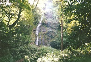
Old photos from a holiday to Exeter in the year 2000 of a Waterfall. It is <a href="http://www.canonteignfalls.co.uk/" rel="noreferrer nofollow">Canonteign Falls</a>. This is the Lady Exmouth Waterfall. In 1880 Lady Susan Exmouth created this present waterfall, diverting water from the original natural falls which still tumble down through the secret garden away to the left. Lady Susan employed the local miners who lost their jobs when the Frank Mills Mine closed in 1880. The miners restored and redirected the leat that originally fed water to the mine and the resulting waterfalls, 220ft (67 metres) were and still are, the highest falls in England and a tremendous example of the 'Victorian Folly'. The leat was an impressive feat of engineering drawing water from further up the valley. At one stage this water was used to power an overshot waterwheel at a timber sawmill Lady Susan established at the foot of the Falls. This was another initiative to create employment and prosperity in the area. The water was channelled down wooden launders (chutes) to the mill and you can see evidence of these in the banks near the bottom Clampitt Falls. A circular concrete reservoir near Bruce's Pond acted as a filter for some of the water which was piped to the miners cottages, the remains of which can be seen near the old airshaft by the children's assault course. Large iron pipes which carried the water to the mine and later to the cottages are still evident near the pathways near Lady Exmouth's Bridge. <a href="http://www.canonteignfalls.co.uk/Home/Days-out-in-Devon-at-Lady-Exmouth-Falls.html" rel="noreferrer nofollow">Lady Exmouth Waterfall </a> |
| Date | |
| Source | Canonteign Falls - Waterfall near Exeter - 2000 - Lady Exmouth Waterfall |
| Author | Elliott Brown from Birmingham, United Kingdom |
| Camera location | | View this and other nearby images on: OpenStreetMap |
|---|
.jpg¶ms=050.630415_N_-003.649660_E_globe:Earth_type:camera_source:Flickr_&language=en)
Licensing[edit]
.jpg&action=edit§ion=2)
- You are free:
- to share – to copy, distribute and transmit the work
- to remix – to adapt the work
- Under the following conditions:
- attribution – You must give appropriate credit, provide a link to the license, and indicate if changes were made. You may do so in any reasonable manner, but not in any way that suggests the licensor endorses you or your use.
| This image was originally posted to Flickr by ell brown at https://flickr.com/photos/39415781@N06/5371099988. It was reviewed on 9 November 2020 by FlickreviewR 2 and was confirmed to be licensed under the terms of the cc-by-2.0. |
File history
Click on a date/time to view the file as it appeared at that time.
| Date/Time | Thumbnail | Dimensions | User | Comment | |
|---|---|---|---|---|---|
| current | 21:15, 9 November 2020 | | 1,747 × 1,190 (482 KB) | Sic19 (talk | contribs) | Transferred from Flickr via #flickr2commons |
You cannot overwrite this file.
File usage on Commons
There are no pages that use this file.
.jpg&oldid=847438146)