File:Cannich - geograph.org.uk - 1013238.jpg
Jump to navigation
Jump to search
No higher resolution available.
Cannich_-_geograph.org.uk_-_1013238.jpg (640 × 480 pixels, file size: 112 KB, MIME type: image/jpeg)
Captions
Captions
Add a one-line explanation of what this file represents
Summary[edit]
| Description |
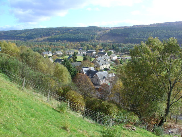
English: Cannich Cannich (Bog Cotton Place), lies in the classic U-shaped glacial valley of Strathglass, which generally runs south west to north east. Three glens lead to/from the village. Glen Cannich to the north west, Glen Affric to the south west and Glenurquhart to the east.
The village was greatly expanded by the arrival of the Hydro Schemes in the area, from the late 1940's. The houses are in MacColl Road, which was named after the Chief Executive and Vice Chairman of the NOSHEB, from 1943 to 1951, Sir Edward MacColl. |
| Date | |
| Source | From geograph.org.uk |
| Author | Alasdair MacDonald |
| Attribution (required by the license) | Alasdair MacDonald / Cannich / |
| Camera location | | View this and other nearby images on: OpenStreetMap |
|---|
_heading:135.00&language=en)
| Object location | | View this and other nearby images on: OpenStreetMap |
|---|
_heading:135.00&language=en)
Licensing[edit]

|
This image was taken from the Geograph project collection. See this photograph's page on the Geograph website for the photographer's contact details. The copyright on this image is owned by Alasdair MacDonald and is licensed for reuse under the Creative Commons Attribution-ShareAlike 2.0 license.
|
This file is licensed under the Creative Commons Attribution-Share Alike 2.0 Generic license.
Attribution: Alasdair MacDonald
- You are free:
- to share – to copy, distribute and transmit the work
- to remix – to adapt the work
- Under the following conditions:
- attribution – You must give appropriate credit, provide a link to the license, and indicate if changes were made. You may do so in any reasonable manner, but not in any way that suggests the licensor endorses you or your use.
- share alike – If you remix, transform, or build upon the material, you must distribute your contributions under the same or compatible license as the original.
File history
Click on a date/time to view the file as it appeared at that time.
| Date/Time | Thumbnail | Dimensions | User | Comment | |
|---|---|---|---|---|---|
| current | 10:18, 23 February 2011 | | 640 × 480 (112 KB) | GeographBot (talk | contribs) | == {{int:filedesc}} == {{Information |description={{en|1=Cannich Cannich (Bog Cotton Place), lies in the classic U-shaped glacial valley of Strathglass, which generally runs south west to north east. Three glens lead to/from the village. Glen Cannich to t |
You cannot overwrite this file.
File usage on Commons
The following page uses this file:
File usage on other wikis
The following other wikis use this file: