File:California’s Lake Oroville at an historical record low level.jpg

Original file (4,800 × 2,760 pixels, file size: 6.71 MB, MIME type: image/jpeg)
Captions
Captions
Summary[edit]
| Description |
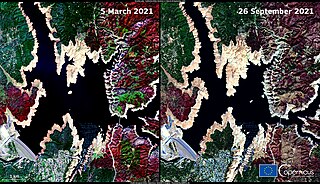
English: Droughts on the US West Coast continue to worsen. According to data from the California Department of Water Resources, many reservoirs are at the lowest level ever recorded for these bodies of water. These two images, acquired by a Copernicus Sentinel-2 satellite on 5 March (left) and 26 September 2021 (right) provide evidence of the decrease in Lake Oroville's water level, which in March was at 54% of its capacity and at the end of September was at only 22%. Data from Copernicus missions provide information that can be used to accurately map bodies of water and extract critical information during periods of drought. |
| Date | Taken on 5 March 2021 |
| Source | California’s Lake Oroville at an historical record low level |
| Author | European Union, Copernicus Sentinel-2 imagery |
Licensing[edit]

|
This image contains data from a satellite in the Copernicus Programme, such as Sentinel-1, Sentinel-2 or Sentinel-3. Attribution is required when using this image.
Attribution: Contains modified Copernicus Sentinel data 2021
The use of Copernicus Sentinel Data is regulated under EU law (Commission Delegated Regulation (EU) No 1159/2013 and Regulation (EU) No 377/2014). Relevant excerpts:
Free access shall be given to GMES dedicated data [...] made available through GMES dissemination platforms [...].
Access to GMES dedicated data [...] shall be given for the purpose of the following use in so far as it is lawful:
GMES dedicated data [...] may be used worldwide without limitations in time.
GMES dedicated data and GMES service information are provided to users without any express or implied warranty, including as regards quality and suitability for any purpose. |
File history
Click on a date/time to view the file as it appeared at that time.
| Date/Time | Thumbnail | Dimensions | User | Comment | |
|---|---|---|---|---|---|
| current | 08:27, 27 August 2023 | | 4,800 × 2,760 (6.71 MB) | OptimusPrimeBot (talk | contribs) | #Spacemedia - Upload of https://www.copernicus.eu/system/files/2021-09/image_day/20210928_OrovilleLake.jpg via Commons:Spacemedia |
You cannot overwrite this file.
File usage on Commons
The following page uses this file:
.jpg&redirect=no)