File:Cairo Tower, al-Qāhirah, CG, EGY (47119632244).jpg
Jump to navigation
Jump to search

Size of this preview: 449 × 599 pixels. Other resolutions: 180 × 240 pixels | 360 × 480 pixels | 575 × 768 pixels | 767 × 1,024 pixels | 1,525 × 2,035 pixels.
Original file (1,525 × 2,035 pixels, file size: 527 KB, MIME type: image/jpeg)
Captions
Captions
Add a one-line explanation of what this file represents
Summary[edit]
.jpg&action=edit§ion=1)
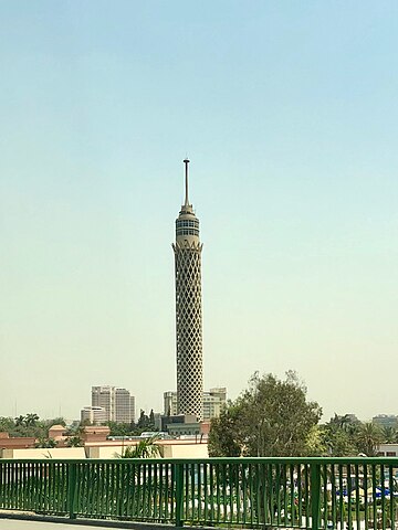
| Description | Standing tall on the city’s skyline, the Cairo Tower is a result of a very unique set of political circumstances in the mid-20th Century, created by the confluence of Arab Nationalism and two superpowers vying for favors from the nation’s leaders. Designed by Egyptian architect Naoum Shebib and constructed between 1956 and 1961, the tower is the tallest building in North Africa, and was the tallest in Africa until 1971. Standing 614 feet (187 meters) tall, the structure stands on Geizera Island in the middle of the Nile River in the center of Cairo. The open latticework of the structure is meant to resemble the native Lotus plant, the structure is topped with an observation deck and rotating restaurant that provide spectacular views of greater Cairo, with the top of the tower being a spire that serves as a major conduit for wireless communication in the city. The structure was revealed after its construction under Egyptian President Gamal Abdel Nasser to have been funded by money that was given to Nasser by the United States Government in the 1950s, which was intended to bribe Nasser into aligning with the interests of the United States. This gesture was seen as offensive to Nasser, whom publicly rebuked the United States government by using it to fund the tower, a symbol of Arab pride and resistance to foreign influence. The tower today is a major landmark in Cairo, and, between 2004 and 2009, saw a major refurbishment to refresh the tower’s aging components, allowing it to remain a symbol of modern, postcolonial Egypt. |
| Date | |
| Source | Cairo Tower, al-Qāhirah, CG, EGY |
| Author | Warren LeMay from Chicago, IL, United States |
| Camera location | | View this and other nearby images on: OpenStreetMap |
|---|
.jpg¶ms=030.049630_N_0031.226406_E_globe:Earth_type:camera_source:Flickr_&language=en)
Licensing[edit]
.jpg&action=edit§ion=2)
| This file is made available under the Creative Commons CC0 1.0 Universal Public Domain Dedication. | |
| The person who associated a work with this deed has dedicated the work to the public domain by waiving all of their rights to the work worldwide under copyright law, including all related and neighboring rights, to the extent allowed by law. You can copy, modify, distribute and perform the work, even for commercial purposes, all without asking permission.
|
| This image was originally posted to Flickr by w_lemay at https://flickr.com/photos/59081381@N03/47119632244. It was reviewed on 19 February 2024 by FlickreviewR 2 and was confirmed to be licensed under the terms of the cc-zero. |
File history
Click on a date/time to view the file as it appeared at that time.
| Date/Time | Thumbnail | Dimensions | User | Comment | |
|---|---|---|---|---|---|
| current | 00:49, 19 February 2024 | | 1,525 × 2,035 (527 KB) | Tm (talk | contribs) | Transferred from Flickr via #flickr2commons |
You cannot overwrite this file.
File usage on Commons
There are no pages that use this file.
.jpg&oldid=870387502)