File:Ca. 1909 Ottoman map of the Ottoman Iraq - Iran border by the Special Border Commission.jpg
Jump to navigation
Jump to search

Size of this preview: 800 × 268 pixels. Other resolutions: 320 × 107 pixels | 640 × 214 pixels | 1,024 × 343 pixels | 1,280 × 429 pixels | 2,560 × 858 pixels | 30,000 × 10,054 pixels.
Original file (30,000 × 10,054 pixels, file size: 30.06 MB, MIME type: image/jpeg)
Captions
Captions
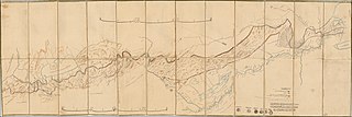
ca. 1909 Ottoman map of the Ottoman Iraq - Iran border by the Special Border Commission
Summary[edit]
| Warning | The original file is very high-resolution. It might not load properly or could cause your browser to freeze when opened at full size. |
|---|
| Description |
English: ca. 1909 Ottoman map of the Ottoman Iraq - Iran border by the Special Border Commission |
| Date | circa 1909 |
| Source | https://www.raremaps.com/gallery/detail/54908/iraq--iran-border-survey-map-of-the-ottoman-iranian-border-harbiye-nezareti |
| Author |
Harbiye Nezâreti Ministry of War of the Ottoman Empire |
Licensing[edit]
|
This work is in the public domain in its country of origin and other countries and areas where the copyright term is the author's life plus 70 years or fewer. This work is in the public domain in the United States because it was published (or registered with the U.S. Copyright Office) before January 1, 1929. | |
| This file has been identified as being free of known restrictions under copyright law, including all related and neighboring rights. | |
File history
Click on a date/time to view the file as it appeared at that time.
| Date/Time | Thumbnail | Dimensions | User | Comment | |
|---|---|---|---|---|---|
| current | 14:11, 21 February 2020 | 30,000 × 10,054 (30.06 MB) | Balkanique (talk | contribs) | User created page with UploadWizard |
You cannot overwrite this file.
File usage on Commons
The following page uses this file: