File:Buurtspoorwegen Brabant.png
From Wikimedia Commons, the free media repository
Jump to navigation
Jump to search

Size of this preview: 800 × 509 pixels. Other resolutions: 320 × 204 pixels | 640 × 407 pixels | 1,024 × 651 pixels | 1,280 × 814 pixels | 2,122 × 1,350 pixels.
Original file (2,122 × 1,350 pixels, file size: 1.4 MB, MIME type: image/png)
File information
Structured data
Captions
Captions
Add a one-line explanation of what this file represents
Summary[edit]
| DescriptionBuurtspoorwegen Brabant.png |
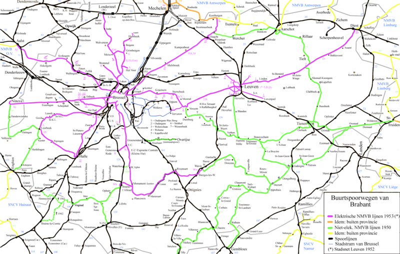
English: Map of the vicinal railways in the province of Brabant.
Nederlands: Kaart van de buurtspoorwegen in de provincie Brabant. |
| Date | |
| Source | Own work |
| Author | Smiley.toerist |
| Other versions |
Details
Neighbour regions
|

|
This transport map image could be re-created using vector graphics as an SVG file. This has several advantages; see Commons:Media for cleanup for more information. If an SVG form of this image is available, please upload it and afterwards replace this template with
{{vector version available|new image name}}.
It is recommended to name the SVG file “Buurtspoorwegen Brabant.svg”—then the template Vector version available (or Vva) does not need the new image name parameter. |
Licensing[edit]
I, the copyright holder of this work, hereby publish it under the following licenses:

|
Permission is granted to copy, distribute and/or modify this document under the terms of the GNU Free Documentation License, Version 1.2 or any later version published by the Free Software Foundation; with no Invariant Sections, no Front-Cover Texts, and no Back-Cover Texts. A copy of the license is included in the section entitled GNU Free Documentation License.http://www.gnu.org/copyleft/fdl.htmlGFDLGNU Free Documentation Licensetruetrue |
This file is licensed under the Creative Commons Attribution-Share Alike 3.0 Unported, 2.5 Generic, 2.0 Generic and 1.0 Generic license.
- You are free:
- to share – to copy, distribute and transmit the work
- to remix – to adapt the work
- Under the following conditions:
- attribution – You must give appropriate credit, provide a link to the license, and indicate if changes were made. You may do so in any reasonable manner, but not in any way that suggests the licensor endorses you or your use.
- share alike – If you remix, transform, or build upon the material, you must distribute your contributions under the same or compatible license as the original.
You may select the license of your choice.
File history
Click on a date/time to view the file as it appeared at that time.
| Date/Time | Thumbnail | Dimensions | User | Comment | |
|---|---|---|---|---|---|
| current | 11:16, 29 September 2021 |  | 2,122 × 1,350 (1.4 MB) | Arflhn (talk | contribs) | Leuven, tram line 2 terminus waw Beneden Kessel, not tram line 3. |
| 12:24, 8 May 2017 |  | 2,122 × 1,350 (1.27 MB) | Smiley.toerist (talk | contribs) | Diverse verbeteringen en fouten gecorrigeerd | |
| 08:23, 31 March 2014 |  | 2,122 × 1,350 (1.27 MB) | Smiley.toerist (talk | contribs) | Line didn't to Ninove railway station. Went to Humbeek (vaart) along the canal. | |
| 12:45, 20 September 2012 |  | 2,122 × 1,350 (1.27 MB) | Smiley.toerist (talk | contribs) | Corrections see discussion page | |
| 16:51, 29 October 2010 |  | 2,122 × 1,350 (1.27 MB) | Smiley.toerist (talk | contribs) | Aanpassingen Tienen, St-Truiden en Jodoigne | |
| 11:35, 5 October 2010 |  | 2,122 × 1,350 (1.26 MB) | Smiley.toerist (talk | contribs) | correction in Haacht, Aarschot en Tremelo from information out of a 1954 map | |
| 08:38, 22 September 2010 |  | 2,122 × 1,350 (1.26 MB) | Smiley.toerist (talk | contribs) | Places added | |
| 12:19, 12 August 2010 |  | 2,122 × 1,350 (1.26 MB) | Smiley.toerist (talk | contribs) | ||
| 08:55, 6 May 2010 |  | 2,122 × 1,350 (1.25 MB) | Smiley.toerist (talk | contribs) | ||
| 13:09, 29 April 2010 |  | 2,122 × 1,350 (1.25 MB) | Smiley.toerist (talk | contribs) |
You cannot overwrite this file.
File usage on Commons
The following 12 pages use this file:
- Top 200 transport map images that should use vector graphics
- User:Chumwa/OgreBot/Potential transport maps/2017 May 1-10
- User:Chumwa/OgreBot/Public transport information/2017 May 1-10
- User:Chumwa/OgreBot/Public transport information/2021 September 21-30
- User:Chumwa/OgreBot/Transport Maps/2017 May 1-10
- User:Chumwa/OgreBot/Transport Maps/2021 September 21-30
- User:Chumwa/OgreBot/Travel and communication maps/2017 May 1-10
- User:Magog the Ogre/Multilingual legend/2021 September 21-30
- File:Brussels SNCV.png
- File:Plan des lignes de tramway dans la province de Brabant 1950-01-01.jpg
- File:Virginal-Samme, voies ferrées SNCV et SNCB.png
- Category:SNCV/NMVB Brabant tram routes
File usage on other wikis
The following other wikis use this file:
- Usage on cs.wikipedia.org
- Usage on fr.wikipedia.org
- Société nationale des chemins de fer vicinaux
- Lignes de tramway de la SNCV dans la province de Brabant
- Ligne de tramway W (SNCV Groupe de Bruxelles Sud)
- Ligne de tramway Ni
- Ligne de tramway B (SNCV Groupe de Louvain)
- Ligne de tramway 293
- Ligne de tramway 320
- Ligne de tramway 315
- Ligne de tramway 296
- Ligne de tramway 311
- Ligne de tramway 1 (SNCV Groupe de Louvain)
- Ligne de tramway 2 (SNCV Groupe de Louvain)
- Ligne de tramway 4 (SNCV Groupe de Louvain)
- Ligne de tramway 5 (SNCV Groupe de Louvain)
- Ligne de tramway 3 (SNCV Groupe de Louvain)
- Ligne de tramway 322
- Ligne de tramway L (SNCV Groupe de Bruxelles Nord)
- Ligne de tramway L (SNCV Groupe de Bruxelles Sud)
- Ligne de tramway Al
- Ligne de tramway 309
- Ligne de tramway M (SNCV Groupe de Louvain)
- Ligne de tramway W (SNCV Groupe de Bruxelles Nord)
- Ligne de tramway V (SNCV Groupe de Bruxelles Sud)
- Ligne de tramway O (SNCV Groupe de Bruxelles Sud)
- Ligne de tramway M (SNCV Groupe de Bruxelles Nord)
- Ligne de tramway H (SNCV Groupe de Bruxelles Nord)
- Ligne de tramway H (SNCV Groupe de Bruxelles Sud)
- Ligne de tramway F (SNCV Groupe de Bruxelles Sud)
- Ligne de tramway A (SNCV Groupe de Bruxelles Sud)
- Ligne de tramway 325
- Ligne de tramway 326
- Ligne de tramway 324
- Ligne de tramway 305B
- Ligne de tramway 305A
- Usage on nl.wikipedia.org
Metadata
This file contains additional information such as Exif metadata which may have been added by the digital camera, scanner, or software program used to create or digitize it. If the file has been modified from its original state, some details such as the timestamp may not fully reflect those of the original file. The timestamp is only as accurate as the clock in the camera, and it may be completely wrong.
| Horizontal resolution | 28.35 dpc |
|---|---|
| Vertical resolution | 28.35 dpc |


