File:Burstwick Castle - geograph.org.uk - 209312.jpg
Jump to navigation
Jump to search
No higher resolution available.
Burstwick_Castle_-_geograph.org.uk_-_209312.jpg (640 × 395 pixels, file size: 114 KB, MIME type: image/jpeg)
Captions
Captions
Add a one-line explanation of what this file represents
Summary[edit]
| Description |
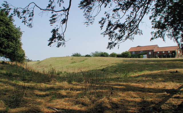
English: Burstwick Castle, north west of Burstwick, East Riding of Yorkshire, England. Earthworks (particularly those showing the course of the moat) are pretty much all that remains of Burstwick Hall Garth, or 'Burstwick Castle'. The fortified manor was a 13th century royal residence built largely of timber and consisting of a hall, one or possibly two chapels, chambers, kitchen and stable. Different sources have the moat being added in either 1291 or 1334. The manor's most famous (if reluctant) resident was Elizabeth de Burgh, Queen of Scots and wife of Robert the Bruce who was imprisoned here before being moved to Bisham Abbey Manor, Berkshire in 1308. |
| Date | |
| Source | From geograph.org.uk |
| Author | Paul Glazzard |
| Permission (Reusing this file) |
Creative Commons Attribution Share-alike license 2.0 |
| Attribution (required by the license) | Paul Glazzard / Burstwick Castle / |
| Object location | | View this and other nearby images on: OpenStreetMap |
|---|
_heading:135.00&language=en)
Licensing[edit]

|
This image was taken from the Geograph project collection. See this photograph's page on the Geograph website for the photographer's contact details. The copyright on this image is owned by Paul Glazzard and is licensed for reuse under the Creative Commons Attribution-ShareAlike 2.0 license.
|
This file is licensed under the Creative Commons Attribution-Share Alike 2.0 Generic license.
Attribution: Paul Glazzard
- You are free:
- to share – to copy, distribute and transmit the work
- to remix – to adapt the work
- Under the following conditions:
- attribution – You must give appropriate credit, provide a link to the license, and indicate if changes were made. You may do so in any reasonable manner, but not in any way that suggests the licensor endorses you or your use.
- share alike – If you remix, transform, or build upon the material, you must distribute your contributions under the same or compatible license as the original.
File history
Click on a date/time to view the file as it appeared at that time.
| Date/Time | Thumbnail | Dimensions | User | Comment | |
|---|---|---|---|---|---|
| current | 17:32, 31 January 2010 | | 640 × 395 (114 KB) | GeographBot (talk | contribs) | == {{int:filedesc}} == {{Information |description={{en|1=Burstwick Castle. Earthworks (particularly those showing the course of the moat) are pretty much all that remains of Burstwick Hall Garth, or 'Burstwick Castle'. The fortified manor was a 13th centu |
You cannot overwrite this file.
File usage on Commons
There are no pages that use this file.