File:Bundesarchiv Bild 183-Z0309-310, Zerstörtes Dresden.jpg
Jump to navigation
Jump to search
No higher resolution available.
Bundesarchiv_Bild_183-Z0309-310,_Zerstörtes_Dresden.jpg (795 × 537 pixels, file size: 314 KB, MIME type: image/jpeg)
Captions
Captions
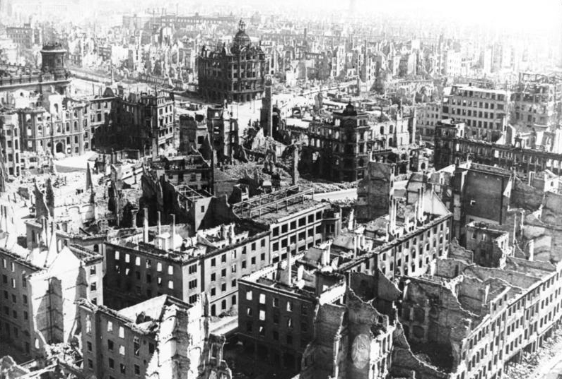
Downtown Dresden after the bombings in 1945
Summary[edit]
| Dresden, Zerstörungen
( |
|||||||||||||||||||||||||||
|---|---|---|---|---|---|---|---|---|---|---|---|---|---|---|---|---|---|---|---|---|---|---|---|---|---|---|---|
| Photographer |
Beyer, G. |
||||||||||||||||||||||||||
| Title |
Dresden, Zerstörungen |
||||||||||||||||||||||||||
| Original caption |
For documentary purposes the German Federal Archive often retained the original image captions, which may be erroneous, biased, obsolete or politically extreme. ADN-ZB/G. Beyer
Dresden 1945: Blick vom Rathausturm auf die zerstörte Stadt. Im Vordergrund der heutige Pirnaische Platz. |
||||||||||||||||||||||||||
| Depicted place | Dresden | ||||||||||||||||||||||||||
| Date | 1945 | ||||||||||||||||||||||||||
| Collection |
|
||||||||||||||||||||||||||
| Current location |
Allgemeiner Deutscher Nachrichtendienst - Zentralbild (Bild 183) |
||||||||||||||||||||||||||
| Accession number | |||||||||||||||||||||||||||
| Source |
|
||||||||||||||||||||||||||

| Camera location | | View this and other nearby images on: OpenStreetMap |
|---|
Licensing[edit]
This file is licensed under the Creative Commons Attribution-Share Alike 3.0 Germany license.
Attribution: Bundesarchiv, Bild 183-Z0309-310 / G. Beyer / CC-BY-SA 3.0
- You are free:
- to share – to copy, distribute and transmit the work
- to remix – to adapt the work
- Under the following conditions:
- attribution – You must give appropriate credit, provide a link to the license, and indicate if changes were made. You may do so in any reasonable manner, but not in any way that suggests the licensor endorses you or your use.
- share alike – If you remix, transform, or build upon the material, you must distribute your contributions under the same or compatible license as the original.

| Annotations | This image is annotated: View the annotations at Commons |
| Object location | | View this and other nearby images on: OpenStreetMap |
|---|
File history
Click on a date/time to view the file as it appeared at that time.
| Date/Time | Thumbnail | Dimensions | User | Comment | |
|---|---|---|---|---|---|
| current | 10:23, 30 January 2012 | | 795 × 537 (314 KB) | AndreasPraefcke (talk | contribs) | Reverted to version as of 20:21, 5 December 2008 |
| 08:38, 15 January 2012 |  | 796 × 538 (154 KB) | Jakuzem (talk | contribs) | Reduced file size by selecting higher compression (90 %). Original image used as a source. | |
| 20:21, 5 December 2008 |  | 795 × 537 (314 KB) | Greenshed (talk | contribs) | slight crop to remove irregular border | |
| 20:16, 5 December 2008 |  | 800 × 537 (242 KB) | Greenshed (talk | contribs) | removing caption | |
| 18:43, 4 December 2008 |  | 800 × 560 (105 KB) | BArchBot (talk | contribs) | == Summary == {{Information |Description={{BArch-description|1='''Zerstörtes Dresden''' ADN-ZB/G. Beyer Dresden 1945: Blick vom Rathausturm auf die zerstörte Stadt. Im Vordergrund der heutige Pirnaische Platz. }} |Source=Deutsches Bundesarchiv (German |
You cannot overwrite this file.
File usage on Commons
The following page uses this file:
File usage on other wikis
The following other wikis use this file:
- Usage on azb.wikipedia.org
- Usage on cs.wikipedia.org
- Usage on cv.wikipedia.org
- Usage on cy.wikipedia.org
- Usage on da.wikipedia.org
- Usage on de.wikipedia.org
- 13. Februar
- Diskussion:Deutschland/Archiv/1
- Portal:Imperialismus und Weltkriege/Exzellente Artikel
- Pirnaischer Platz
- Luftangriffe auf Dresden
- Diskussion:Deutschland/Archiv/2
- Kaiserpalast (Dresden)
- Diskussion:Grunaer Straße
- Portal:Dresden/Galerie der Besten
- Theodor Buhl
- Wikipedia Diskussion:Hauptseite/Artikel des Tages/Archiv/Vorschläge/2020/Q1
- Wikipedia:Hauptseite/Archiv/13. Februar 2020
- Benutzer Diskussion:Недєляєва Дар'я
- Usage on de.wikibooks.org
- Usage on de.wikinews.org
- Usage on de.wiktionary.org
- Usage on dsb.wikipedia.org
- Usage on en.wikipedia.org
- Usage on eo.wikipedia.org
- Usage on es.wikipedia.org
- Usage on fa.wikipedia.org
- Usage on fi.wikipedia.org
- Usage on fr.wikipedia.org
- Usage on he.wikipedia.org
- Usage on hr.wikipedia.org
- Usage on hsb.wikipedia.org
- Usage on hu.wikipedia.org
- Usage on id.wikipedia.org
- Usage on it.wikipedia.org
- Usage on ka.wikipedia.org
- Usage on ko.wikipedia.org
View more global usage of this file.