File:Bucovina Romania Ukraine.png
Jump to navigation
Jump to search

Size of this preview: 800 × 537 pixels. Other resolutions: 320 × 215 pixels | 640 × 430 pixels | 1,024 × 688 pixels | 1,266 × 850 pixels.
Original file (1,266 × 850 pixels, file size: 167 KB, MIME type: image/png)
Captions
Captions
Add a one-line explanation of what this file represents

|
This map image could be re-created using vector graphics as an SVG file. This has several advantages; see Commons:Media for cleanup for more information. If an SVG form of this image is available, please upload it and afterwards replace this template with
{{vector version available|new image name}}.
It is recommended to name the SVG file “Bucovina Romania Ukraine.svg”—then the template Vector version available (or Vva) does not need the new image name parameter. |
Summary[edit]
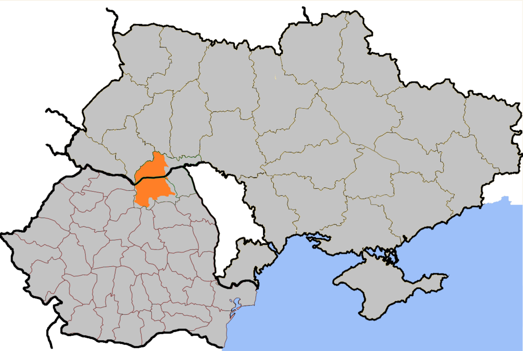
English: Locator map of the Bukovina region definited 1775.

|
Permission is granted to copy, distribute and/or modify this document under the terms of the GNU Free Documentation License, Version 1.2 or any later version published by the Free Software Foundation; with no Invariant Sections, no Front-Cover Texts, and no Back-Cover Texts. A copy of the license is included in the section entitled GNU Free Documentation License. |
| This file is licensed under the Creative Commons Attribution-Share Alike 3.0 Unported license. | ||
| ||
| This licensing tag was added to this file as part of the GFDL licensing update. |
- Credits
- Made by Bogdan Giuşcă.
File history
Click on a date/time to view the file as it appeared at that time.
| Date/Time | Thumbnail | Dimensions | User | Comment | |
|---|---|---|---|---|---|
| current | 15:29, 27 March 2021 | | 1,266 × 850 (167 KB) | Mzajac (talk | contribs) | Reverted to version as of 22:45, 6 February 2018 (UTC) misleading random and vague blob in eastern Ukraine represents nothing real |
| 16:26, 13 May 2020 |  | 1,266 × 850 (211 KB) | Mewa767 (talk | contribs) | Besssere (realischtischere und nicht politische) Darstellung | |
| 22:45, 6 February 2018 |  | 1,266 × 850 (167 KB) | Berihert (talk | contribs) | Ost-Ukraine fehlerhaft dargestellt | |
| 06:18, 20 October 2017 |  | 1,266 × 850 (211 KB) | Julieta39 (talk | contribs) | Contrasts. Discrete red dots : limits of the old principality of Moldavia. | |
| 19:25, 13 April 2016 |  | 1,266 × 850 (167 KB) | Castellum (talk | contribs) | Reverted to version as of 22:07, 7 November 2013 (UTC) | |
| 19:04, 13 April 2016 |  | 1,266 × 850 (135 KB) | Castellum (talk | contribs) | Reverted to version as of 00:22, 21 February 2009 (UTC) | |
| 22:07, 7 November 2013 |  | 1,266 × 850 (167 KB) | Gryffindor (talk | contribs) | {{Information |Description= |Source={{own}} |Date= |Author= Gryffindor |Permission= |other_versions= }} | |
| 00:22, 21 February 2009 |  | 1,266 × 850 (135 KB) | Olahus (talk | contribs) | correction | |
| 20:11, 5 August 2005 |  | 1,266 × 850 (65 KB) | Bogdan (talk | contribs) | ||
| 20:07, 5 August 2005 |  | 1,291 × 970 (66 KB) | Bogdan (talk | contribs) |
You cannot overwrite this file.
File usage on Commons
The following 3 pages use this file:
File usage on other wikis
The following other wikis use this file:
- Usage on af.wikipedia.org
- Usage on azb.wikipedia.org
- Usage on be-tarask.wikipedia.org
- Usage on be.wikipedia.org
- Usage on ca.wikipedia.org
- Usage on cy.wikipedia.org
- Usage on da.wikipedia.org
- Usage on de.wikipedia.org
- Usage on de.wikivoyage.org
- Usage on el.wiktionary.org
- Usage on en.wikipedia.org
- Usage on en.wikivoyage.org
- Usage on en.wiktionary.org
- Usage on es.wikipedia.org
- Usage on et.wikipedia.org
- Usage on fi.wikipedia.org
- Usage on fr.wikipedia.org
- Usage on fr.wiktionary.org
- Usage on hr.wikipedia.org
- Usage on hu.wikipedia.org
- Usage on hy.wikipedia.org
- Usage on io.wikipedia.org
- Usage on it.wikipedia.org
- Usage on lt.wikipedia.org
- Usage on mk.wikipedia.org
- Usage on mr.wikipedia.org
- Usage on nds-nl.wikipedia.org
- Usage on nds.wikipedia.org
- Usage on nl.wikipedia.org
- Usage on nn.wikipedia.org
- Usage on no.wikipedia.org
- Usage on oc.wikipedia.org
- Usage on pl.wikipedia.org
- Usage on pl.wiktionary.org
- Usage on pt.wikipedia.org
- Usage on ro.wikipedia.org
- Usage on ro.wikivoyage.org
- Usage on ro.wiktionary.org
- Usage on ru.wikipedia.org
View more global usage of this file.