File:Brown Pelican Diving 3-3 (used in NYPL article on the Gulf Oil Spill Disaster) (2843864615).jpg
Original file (1,459 × 2,189 pixels, file size: 1.39 MB, MIME type: image/jpeg)
Captions
Captions
Summary[edit]
_(2843864615).jpg&action=edit§ion=1)
| Description |
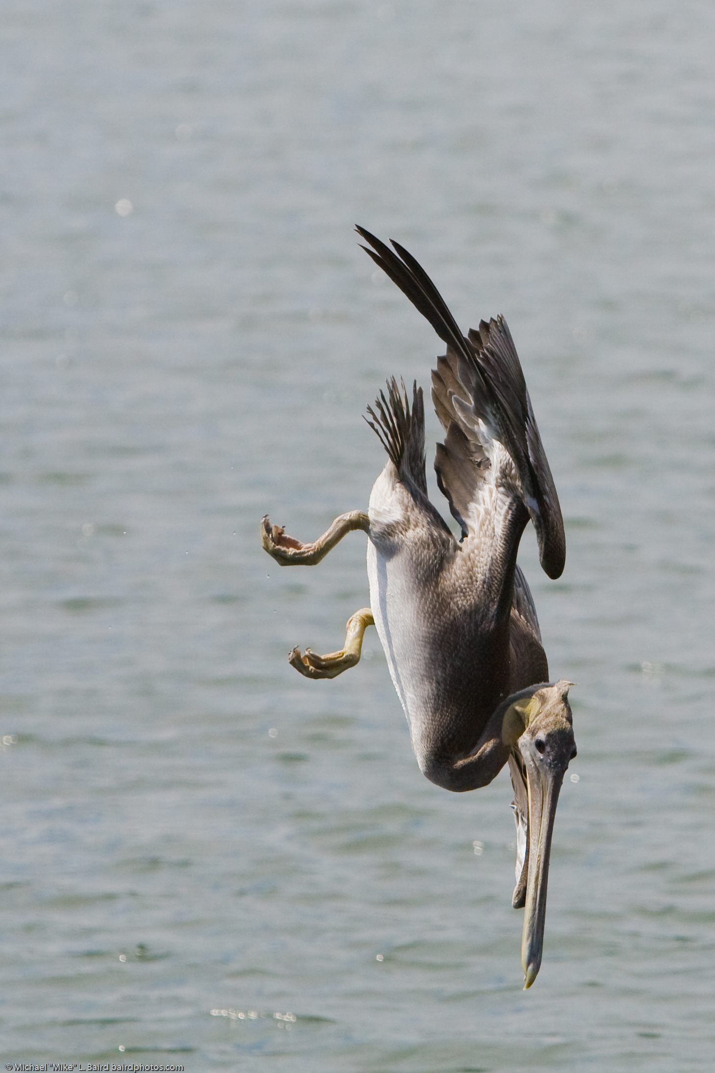
Brown Pelican 3/3 (Pelecanus occidentalis) diving for food, in Morro Bay State Park Marina 09 Sept 2008, Morro Bay, CA. (used in a NYPL article on the Gulf Oil Spill Disaster www.nypl.org/blog/2010/06/22/brown-pelican-reluctant-heroine ) Tech note: 1/8000th sec. helped to guarantee a sharp capture of this fast diving bird. Ten frames per second allowed me to select the pose and height from the water shown here. June 22, 2010. www.nypl.org/blog/2010/06/22/brown-pelican-reluctant-heroine where it says "This spectacular image of the Brown Pelican in action was shot at Morro State Park Marina taken on September, 09, 2008 by amateur photographer "Mike" Michael L.Baird. View Mr. Baird's other stunning images of the Brown Pelican on Flickr." Valerie Wingfield Specialist/Preservation Representative Library Services Center. LIC Manuscripts and Archives Division vwingfield [at} nypl d o t org
|
| Date | |
| Source | Brown Pelican Diving 3/3 (used in NYPL article on the Gulf Oil Spill Disaster) |
| Author | Mike Baird from Morro Bay, USA |
| Camera location | | View this and other nearby images on: OpenStreetMap |
|---|
_(2843864615).jpg¶ms=035.344937_N_-120.840704_E_globe:Earth_type:camera_source:Flickr_&language=en)
Licensing[edit]
_(2843864615).jpg&action=edit§ion=2)
- You are free:
- to share – to copy, distribute and transmit the work
- to remix – to adapt the work
- Under the following conditions:
- attribution – You must give appropriate credit, provide a link to the license, and indicate if changes were made. You may do so in any reasonable manner, but not in any way that suggests the licensor endorses you or your use.
| This image was originally posted to Flickr by mikebaird at https://www.flickr.com/photos/72825507@N00/2843864615. It was reviewed on 24 April 2014 by FlickreviewR and was confirmed to be licensed under the terms of the cc-by-2.0. |
File history
Click on a date/time to view the file as it appeared at that time.
| Date/Time | Thumbnail | Dimensions | User | Comment | |
|---|---|---|---|---|---|
| current | 11:35, 24 April 2014 | | 1,459 × 2,189 (1.39 MB) | Smooth O (talk | contribs) | Transferred from Flickr via Flickr2commons |
You cannot overwrite this file.
File usage on Commons
There are no pages that use this file.
File usage on other wikis
The following other wikis use this file:
- Usage on tr.wikipedia.org
_(2843864615).jpg&oldid=835367657)