File:Brow Monument US Coast and Geodetic Survey Marker.jpg
Jump to navigation
Jump to search

Size of this preview: 800 × 536 pixels. Other resolutions: 320 × 214 pixels | 640 × 428 pixels | 1,024 × 685 pixels | 1,280 × 857 pixels | 2,560 × 1,714 pixels | 3,872 × 2,592 pixels.
Original file (3,872 × 2,592 pixels, file size: 4.09 MB, MIME type: image/jpeg)
Captions
Captions
Add a one-line explanation of what this file represents
Summary
[edit]
| Description |
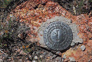
English: This photograph is of a Department of Interior Coast and Geodetic survey marker along the trail to Brow Monument. It is the modern marker located approximately 300 feet from the historical marker cited in the article Brow Monument and Brow Monument Trail |
| Source | United States Dept. of Interior. Coast and Geodetic Survey Marker on Brow Monument Trail, Kaibab National Forest, Arizona |
| Author | United States Dept. of Interior |
Licensing
[edit]
- Object
-

This image or media file contains material based on a work of a United States Department of the Interior employee, created as part of that person's official duties. As a work of the U.S. federal government, such work is in the public domain in the United States. See the Department of the Interior copyright policy for more information. 
- Photograph
- I, the copyright holder of this work, hereby publish it under the following license:


 This file is licensed under the Creative Commons Attribution-Share Alike 3.0 Unported license.
- You are free:
- to share – to copy, distribute and transmit the work
- to remix – to adapt the work
- Under the following conditions:
- attribution – You must give appropriate credit, provide a link to the license, and indicate if changes were made. You may do so in any reasonable manner, but not in any way that suggests the licensor endorses you or your use.
- share alike – If you remix, transform, or build upon the material, you must distribute your contributions under the same or compatible license as the original.
- You are free:
File history
Click on a date/time to view the file as it appeared at that time.
| Date/Time | Thumbnail | Dimensions | User | Comment | |
|---|---|---|---|---|---|
| current | 19:20, 19 September 2012 | | 3,872 × 2,592 (4.09 MB) | Abearfellow (talk | contribs) | {{Information |Description ={{en|1=This photograph is of a Department of Interior Coast and Geodetic survey marker along the trail to Brow Monument. It is the modern marker located approximately 300 feet from the historical marker cited in the art... |
You cannot overwrite this file.
File usage on Commons
The following page uses this file:
File usage on other wikis
The following other wikis use this file:
- Usage on en.wikipedia.org
- Usage on www.wikidata.org