File:Brno-Center map.png
Jump to navigation
Jump to search
Size of this preview: 508 × 599 pixels. Other resolutions: 203 × 240 pixels | 407 × 480 pixels | 915 × 1,079 pixels.
Original file (915 × 1,079 pixels, file size: 1.36 MB, MIME type: image/png)
Captions
Captions
Add a one-line explanation of what this file represents
Summary[edit]
| Description |
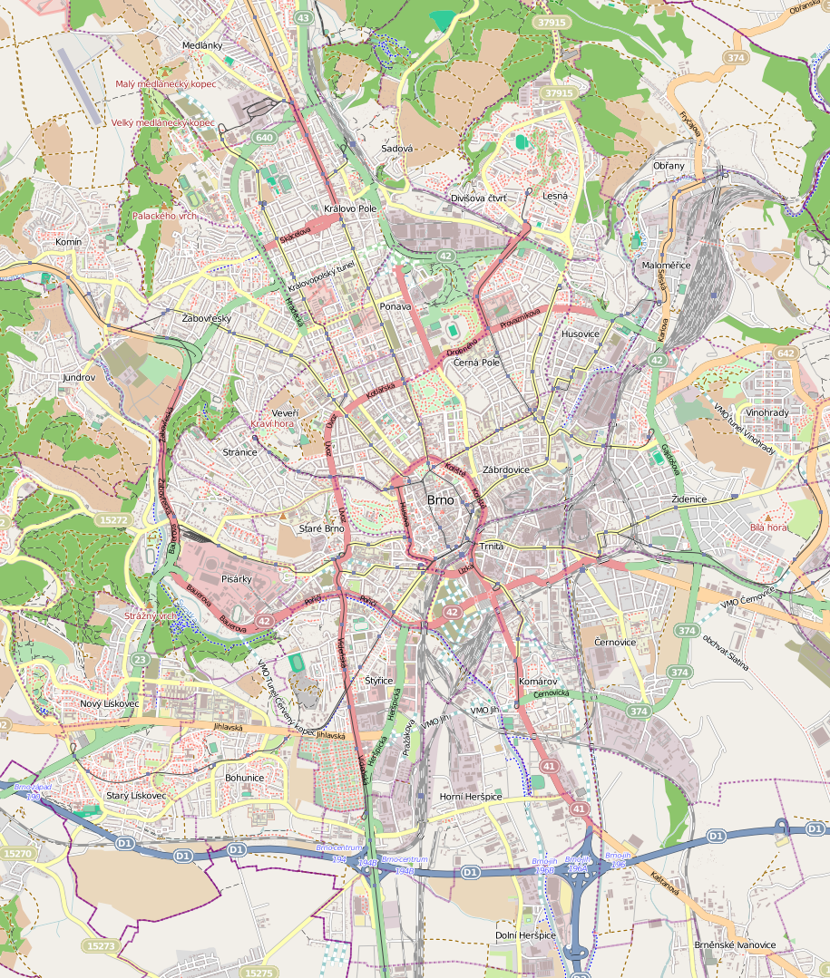
English: A map of Brno-Center, Czech Republic
Čeština: Mapa Brna-střed, Česká republika |
||||||||||||
| Date | |||||||||||||
| Source |
|
||||||||||||
| Author | OpenStreetMap contributors & Loupeznik |
Licensing[edit]
I, the copyright holder of this work, hereby publish it under the following licenses:

|
Permission is granted to copy, distribute and/or modify this document under the terms of the GNU Free Documentation License, Version 1.2 or any later version published by the Free Software Foundation; with no Invariant Sections, no Front-Cover Texts, and no Back-Cover Texts. A copy of the license is included in the section entitled GNU Free Documentation License. |
This file is licensed under the Creative Commons Attribution-Share Alike 3.0 Unported, 2.5 Generic, 2.0 Generic and 1.0 Generic license.
- You are free:
- to share – to copy, distribute and transmit the work
- to remix – to adapt the work
- Under the following conditions:
- attribution – You must give appropriate credit, provide a link to the license, and indicate if changes were made. You may do so in any reasonable manner, but not in any way that suggests the licensor endorses you or your use.
- share alike – If you remix, transform, or build upon the material, you must distribute your contributions under the same or compatible license as the original.
You may select the license of your choice.
File history
Click on a date/time to view the file as it appeared at that time.
| Date/Time | Thumbnail | Dimensions | User | Comment | |
|---|---|---|---|---|---|
| current | 11:25, 15 January 2012 | | 915 × 1,079 (1.36 MB) | Loupeznik (talk | contribs) | {{Information |Description={{en|1=A map of Brno-Center, Czech Republic}} {{cs|1=Mapa Brna-střed, Česká republika}} |Source={{Openstreetmap|name=Brno}} |Date=2012-01-15 |Author=OpenStreetMap contributors & Loupeznik |Permission= |othe |
You cannot overwrite this file.
File usage on Commons
There are no pages that use this file.
File usage on other wikis
The following other wikis use this file:
- Usage on bg.wikipedia.org
- Usage on cs.wikipedia.org
- Usage on eo.wikipedia.org
- Masaryk-Universitato
- Vilao Tugendhat
- Pavilono Anthropos
- Moskeo en Brno
- Fakultato de medicino de la Masaryk-Universitato
- Fakultato de natursciencoj de la Masaryk-Universitato
- Fakultato de informadiko de la Masaryk-Universitato
- Teatro Polárka
- Placo de Libereco (Brno)
- Kemia mezlernejo (Brno)
- Mendel-Universitato en Brno
- Fakultato de regiona evoluo kaj internaciaj studoj de Mendel-universitato en Brno
- Astronomia horloĝo de Brno
- Mahen-biblioteko en Brno
- Katedralo de Sanktaj Petro kaj Paŭlo (Brno)
- Sporta gimnazio de Ludvík Daněk
- Gimnazio Křenová en Brno
- Gimnazio Brno, třída Kapitána Jaroše 14
- Gimnazio INTEGRA BRNO
- Stelobservejo kaj planetario Brno
- VIDA! science centrum
- Muzeo de romaa kulturo
- Teatro Mahen
- Kafejo Zeman
- Ŝablono:Situo sur mapo Ĉeĥio Brno
- Mezlernejo de Elektrotekniko Brno
- Fakultato de juro de la Masaryk-Universitato
- Fakultato de filozofio de la Masaryk-Universitato
- Fakultato de pedagogiko de la Masaryk-Universitato
- Fakultato de farmacio de la Masaryk-Universitato
- Fakultato de sociaj studoj de la Masaryk-Universitato
- Fakultato de sportaj studoj de la Masaryk-Universitato
- Fakultato de ekonomiko kaj administrado de la Masaryk-Universitato
- Mezlernejo teknika kaj ekonomika, Brno, Olomoucká 61
- Usage on fr.wikipedia.org
- Usage on hu.wikipedia.org
View more global usage of this file.