File:British Isles 7C kingdoms with Bernicia and Deira.gif
Original file (902 × 1,166 pixels, file size: 375 KB, MIME type: image/gif)
Captions
Captions
Summary[edit]
| Description |
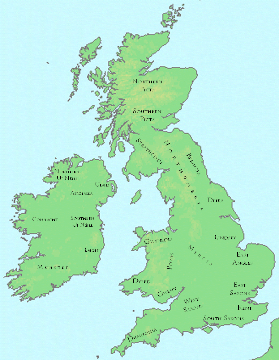
English: This is a map showing the locations of the kingdoms of the British Isles in the late seventh century.
The file was created using DMIS. On that site it is stated that "We do not claim copyright on the images, so you can use them for Wikipedia." This map is based (for Great Britain) on a map found in Peter Hunter Blair's "Roman Britain and Early England: 55 B.C.-871 A.D.", W.W. Norton, 1963, p. 209; and (for Ireland) on a map in Duffy's Atlas of Irish History. |
| Date | |
| Source | Own work |
| Author | Mike_Christie (talk) (Uploads) |
This is a map showing the locations of the kingdoms of the British Isles in the late seventh century.
The file was created using DMIS archive copy at the Wayback Machine. On that site it is stated archive copy at the Wayback Machine that "We do not claim copyright on the images, so you can use them for Wikipedia."
This map is based (for Great Britain) on a map found in Peter Hunter Blair's "Roman Britain and Early England: 55 B.C.-871 A.D.", W.W. Norton, 1963, p. 209; and (for Ireland) on a map in Duffy's Atlas of Irish History.
Licensing[edit]
| This work has been released into the public domain by its author, Mike Christie. This applies worldwide. In some countries this may not be legally possible; if so: |
Original upload log[edit]
Transferred from en.wikipedia to Commons using For the Common Good.
| Date/Time | Dimensions | User | Comment |
|---|---|---|---|
| 14:19, 10 February 2008 | 902 × 1,166 (383,674 bytes) | w:en:Mike Christie (talk | contribs) | This is a map showing the locations of the kingdoms of the British Isles in the late seventh century. The file was created using [http://www.demis.nl/home/pages/home.htm DMIS]. On that site it is [http://support.demis.nl/forums/thread/1295.aspx stated] |
File history
Click on a date/time to view the file as it appeared at that time.
| Date/Time | Thumbnail | Dimensions | User | Comment | |
|---|---|---|---|---|---|
| current | 16:17, 27 July 2015 | | 902 × 1,166 (375 KB) | WikiLeon (talk | contribs) | Transferred from en.wikipedia: see original upload log above |
You cannot overwrite this file.
File usage on Commons
There are no pages that use this file.
File usage on other wikis
The following other wikis use this file: