File:British Islands.svg
Jump to navigation
Jump to search

Size of this PNG preview of this SVG file: 343 × 600 pixels. Other resolutions: 137 × 240 pixels | 274 × 480 pixels | 439 × 768 pixels | 586 × 1,024 pixels | 1,171 × 2,048 pixels | 675 × 1,180 pixels.
Original file (SVG file, nominally 675 × 1,180 pixels, file size: 243 KB)
Captions
Captions
Add a one-line explanation of what this file represents
Summary[edit]
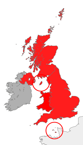
| Description | map showing the territory referred to as "the British Islands" in relation to Great Britain and Ireland (namely the United Kingdom plus the Crown Dependencies, but not the Republic of Ireland) |
| Date | |
| Source | Own work |
| Author | Cnbrb |
| SVG development |
Licensing[edit]
| I, the copyright holder of this work, release this work into the public domain. This applies worldwide. In some countries this may not be legally possible; if so: I grant anyone the right to use this work for any purpose, without any conditions, unless such conditions are required by law. |
File history
Click on a date/time to view the file as it appeared at that time.
| Date/Time | Thumbnail | Dimensions | User | Comment | |
|---|---|---|---|---|---|
| current | 12:45, 28 October 2016 | | 675 × 1,180 (243 KB) | Smyth (talk | contribs) | Highlight crown dependencies, otherwise map looks identical to File:British Isles United Kingdom.svg at small sizes. |
| 21:32, 20 October 2007 |  | 675 × 1,180 (241 KB) | Cnbrb (talk | contribs) | == Summary == {{Information |Description=map showing the territory referred to as "the British Islands" in relation to Great Britain and Ireland (namely the United Kingdom plus the Crown Dependencies, but not the Republic of Ireland) |Source=self-made |Da |
You cannot overwrite this file.
File usage on Commons
The following 2 pages use this file:
File usage on other wikis
The following other wikis use this file:
- Usage on cs.wikipedia.org
- Usage on en.wikipedia.org
- Usage on es.wikipedia.org
- Usage on fa.wikipedia.org
- Usage on fr.wiktionary.org
- Usage on he.wikipedia.org
- Usage on hu.wikipedia.org
- Usage on id.wikipedia.org
- Usage on it.wikipedia.org
- Usage on kk.wikipedia.org
- Usage on lt.wikipedia.org
- Usage on ru.wikipedia.org
- Usage on si.wikipedia.org
- Usage on sr.wikipedia.org
- Usage on sv.wikipedia.org
- Usage on tr.wikipedia.org
- Usage on uk.wikipedia.org
- Usage on vi.wikipedia.org
- Usage on zh.wikipedia.org