File:British Coin 4.jpg

From Wikimedia Commons, the free media repository
Jump to navigation Jump to search

Original file(308 × 622 pixels, file size: 40 KB, MIME type: image/jpeg)

Captions

Captions

Add a one-line explanation of what this file represents

Summary[edit]

English: British Coins   (Wikidata search (Cirrus search) Wikidata query (SPARQL)  Create new Wikidata item based on this file)
Author
Herman Moll  (1654–1732)  wikidata:Q1610319
 
Herman Moll
Alternative names
Moll, Hermann
Description British cartographer, engraver and publisher
Date of birth/death circa 1654
date QS:P,+1654-00-00T00:00:00Z/9,P1480,Q5727902
22 September 1732 Edit this at Wikidata
Location of birth/death Unknown placeUnknown place London
Work location
Authority file
creator QS:P170,Q1610319
Title
English: British Coins
Description
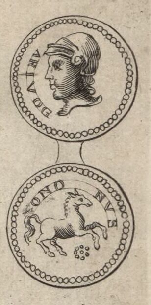
English: A depiction of the obverse and reverse of a Gallic silver coin from the figures decorating the margins of Moll's map of Gloucestershire, sold separately and as Map 14 in his Set of Fifty New and Correct Maps of England and Wales...


The illustration derives from figure 25 of Tabula I Nummi Britannici on Page 87 of William Camden's Britannia, Vol. I. Camden provided no note himself. Walker's notes on Camden printed in the English translation read "The twenty-fifth, Arivogius, is, both by Speed and Archbishop Usher, thought to be Arviragus; of whom more co. 27. Ononus I understand not." Walker's note on figure 27 reads "The twenty-seventh, a crowned head, with many strings of pearls about it, is thought to be Arviragus. I wish there were more than bare conjectures for it. For I do not find that Arviragus was a Christian, as this coin declares, there being a cross and a string of pearls about it; an ordinary ornament of the cross in the first peaceable times of the church. Harding, I think, is the only author who affirms him a Christian: but 'Tis generally said, erga religionem Christianam bene affectus [That he was well disposed to the Christian religion], and that he gave to the first preachers of Glastonbury so many hides of land, as helped much to maintain them. And Gildas saith, that it was well known that the Christian religion was brought into Britain in the latter end of Tiberius's time. He lived in great reputation in Domitian's time, whose flatterers, upon some prodigies appearing, foretold him of some great good fortune to him, as that Arviragus should be thrown down from his chariot." The existence of any figure by the name is questionable (with some ascribing it to a misunderstanding of a latinization of a British term for high chief) but subsequent discoveries show these coins to have a fuller inscription ARIVOS SANTONOS, ascribing them to the Santoni chief or a Santoni chief named Arivos in Gaul (1, 2)

Notes:
Obverse: ARIVOG [sic, actually ARVIOS]
Reverse: ONONVS [sic, actually SANTONOS]
London: Sold by H. Moll over-against Devereux-Court in the Strand; Tho. Bowles, Print and Map-Seller near the Chapter-House in St. Paul's Church-Yard, and J. Bowles Print and Map-Seller over-against Stocks-Market. 1724.


Français : Sujet : Monnaies

Divisions politiques et administratives Gloucester, Comté de -- Divisions politiques et administratives Échelle(s) : 10 English Miles [= 3,8 cm] Référence bibliographique : 173 Appartient à l’ensemble documentaire : AnvilEur Appartient à l’ensemble documentaire : MAEDI008 Appartient à l’ensemble documentaire : MAEDIGen0 Couverture : Royaume-Uni – Angleterre – Gloucestershire Langue : anglais

Éditeur : [T. Bowles] (London)
Date

Original coin: 1st century BC or AD
Camden's engraving: 1586

Moll's engraving: 1724
Dimensions height: 33 cm (12.9 in); width: 21 cm (8.2 in)
dimensions QS:P2048,33U174728
dimensions QS:P2049,21U174728
institution QS:P195,Q193563
References
Français : Notice de recueil : http://catalogue.bnf.fr/ark:/12148/cb40577015h

Appartient à : Collection d'Anville ; 02187 Notice du catalogue : http://catalogue.bnf.fr/ark:/12148/cb41247598d

Extrait de A New Description of England and Wales, With the Adjacent Islands, 1724.
Source/Photographer
Français : Bibliothèque nationale de France, département Cartes et plans, GE DD-2987 (2187)
Bibliothèque nationale de France
Permission
(Reusing this file)
Previous public domain rationale, no longer applicable
Public domain
This image from the Bibliothèque nationale de France (BnF) is a reproduction by scanning of a bidimensional work that is now in the public domain ({{PD-scan}}). For this reason, it is in the public domain.
This image can also be seen on Gallica: Image btv1b53056595p.

العربية  Deutsch  English  español  français  galego  italiano  日本語  македонски  Nederlands  português  русский  sicilianu  slovenščina  українська  +/−

Other versions
Annotations
InfoField
This image is annotated: View the annotations at Commons

File history

Click on a date/time to view the file as it appeared at that time.

Date/TimeThumbnailDimensionsUserComment
current08:52, 9 November 2023Thumbnail for version as of 08:52, 9 November 2023308 × 622 (40 KB)LlywelynII (talk | contribs)File:Glocester Shire - By H. Moll Geographer - btv1b53056595p.jpg cropped using CropTool.