File:British Coin 3.jpg
Original file (286 × 658 pixels, file size: 47 KB, MIME type: image/jpeg)
Captions
Captions
Summary[edit]
| English: British Coins
( |
|||||||||||||||||||||||||||
|---|---|---|---|---|---|---|---|---|---|---|---|---|---|---|---|---|---|---|---|---|---|---|---|---|---|---|---|
| Author |
|
||||||||||||||||||||||||||
| Title |
English: British Coins |
||||||||||||||||||||||||||
| Description |
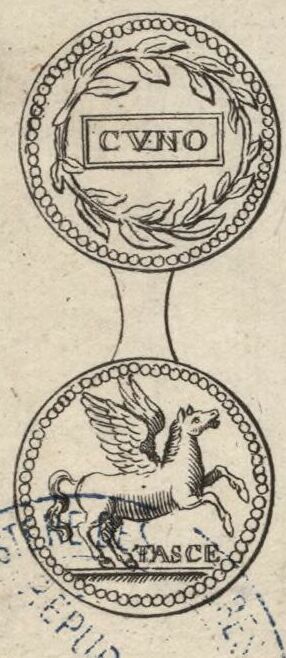
English: A depiction of the obverse and reverse of a silver coin of Cunobelinus from the figures decorating the margins of Moll's map of Gloucestershire, sold separately and as Map 14 in his Set of Fifty New and Correct Maps of England and Wales... The illustration derives from figure 18 of Tabula I Nummi Britannici on Page 87 of William Camden's Britannia, Vol. I. Camden's English text for the coin reads "The 18th Cuno within a laurel garland; and on the reverse, a horse, with TASCE." In the Numismatic Chronicle, Vol. VII, p. 78, Samuel Birch later established that the correct reading should have been TASCF for Tasciovani filius, "son of Tasciovanus" (1).
Français : Sujet : Monnaies
Divisions politiques et administratives Gloucester, Comté de -- Divisions politiques et administratives Échelle(s) : 10 English Miles [= 3,8 cm] Référence bibliographique : 173 Appartient à l’ensemble documentaire : AnvilEur Appartient à l’ensemble documentaire : MAEDI008 Appartient à l’ensemble documentaire : MAEDIGen0 Couverture : Royaume-Uni – Angleterre – Gloucestershire Langue : anglais Éditeur : [T. Bowles] (London) |
||||||||||||||||||||||||||
| Date |
Original coin: AD 9–40 |
||||||||||||||||||||||||||
| Dimensions | height: 33 cm (12.9 in); width: 21 cm (8.2 in) | ||||||||||||||||||||||||||
| Collection |
|
||||||||||||||||||||||||||
| References |
Français : Notice de recueil : http://catalogue.bnf.fr/ark:/12148/cb40577015h
Appartient à : Collection d'Anville ; 02187 Notice du catalogue : http://catalogue.bnf.fr/ark:/12148/cb41247598d Extrait de A New Description of England and Wales, With the Adjacent Islands, 1724. |
||||||||||||||||||||||||||
| Source/Photographer |
Français : Bibliothèque nationale de France, département Cartes et plans, GE DD-2987 (2187)
Bibliothèque nationale de France |
||||||||||||||||||||||||||
| Permission (Reusing this file) |
|
||||||||||||||||||||||||||
| Other versions |
|
||||||||||||||||||||||||||


File history
Click on a date/time to view the file as it appeared at that time.
| Date/Time | Thumbnail | Dimensions | User | Comment | |
|---|---|---|---|---|---|
| current | 08:52, 9 November 2023 | | 286 × 658 (47 KB) | LlywelynII (talk | contribs) | File:Glocester Shire - By H. Moll Geographer - btv1b53056595p.jpg cropped using CropTool. |
You cannot overwrite this file.
File usage on Commons
The following 5 pages use this file:
- Maps from Gallica
- 1724 engravings
- A Set of Fifty New and Correct Maps of England and Wales
- Coins of Cunobelinus
- Britannia: or, a Chorographical Description of the Flourishing Kingdoms of England, Scotland, and Ireland, and the Islands
- Horses on Celtic coins
- Pegasus in Ancient art
- Laurel wreaths in art
- Both sides of coins
- Latin inscriptions on coins
- 0s coins
- 10s coins
- 20s coins
- 30s coins
- 40s coins
- Silver coins