File:Brazil Sul demographic map.png
Jump to navigation
Jump to search
No higher resolution available.
Brazil_Sul_demographic_map.png (651 × 443 pixels, file size: 18 KB, MIME type: image/png)
Captions
Captions
Add a one-line explanation of what this file represents
Summary[edit]
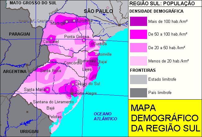
| Description | South of Brazil demographic map. |
| Date | |
| Source | Deyvid Aleksandr Raffo Setti. |
| Author | Deyvid Aleksandr Raffo Setti. |
| Permission (Reusing this file) |
This geographic map can be used for any educational, personal or commercial purposes. |
Licensing[edit]
| I, the copyright holder of this work, release this work into the public domain. This applies worldwide. In some countries this may not be legally possible; if so: I grant anyone the right to use this work for any purpose, without any conditions, unless such conditions are required by law. |
Original upload log[edit]
| Date/Time | Dimensions | User | Comment |
|---|---|---|---|
| 6 July 2006, 21:25:24 | 651 × 443 (23670 bytes) | Deyvid Setti (talk · contribs) | {{Information| |Description = South of Brazil demographic map. |Source = Deyvid Aleksandr Raffo Setti. |Date = created 06. Jul. 2006. |Author = Deyvid Aleksandr Raffo Setti. |Permission = This geographic map can be used for any educational, personal or co |
File history
Click on a date/time to view the file as it appeared at that time.
| Date/Time | Thumbnail | Dimensions | User | Comment | |
|---|---|---|---|---|---|
| current | 10:14, 26 August 2014 | | 651 × 443 (18 KB) | GifTagger (talk | contribs) | Bot: Converting file to superior PNG file. (Source: Brazil_Sul_demographic_map.gif). This GIF was problematic due to non-greyscale color table. |
You cannot overwrite this file.
File usage on Commons
The following page uses this file:
- File:Brazil Sul demographic map.gif (file redirect)
File usage on other wikis
The following other wikis use this file: