File:Bourbon Lane - award winning development near Westfield - geograph.org.uk - 1069551.jpg
Jump to navigation
Jump to search
No higher resolution available.
Bourbon_Lane_-_award_winning_development_near_Westfield_-_geograph.org.uk_-_1069551.jpg (640 × 480 pixels, file size: 84 KB, MIME type: image/jpeg)
Captions
Captions
Add a one-line explanation of what this file represents
Summary[edit]
| Description |
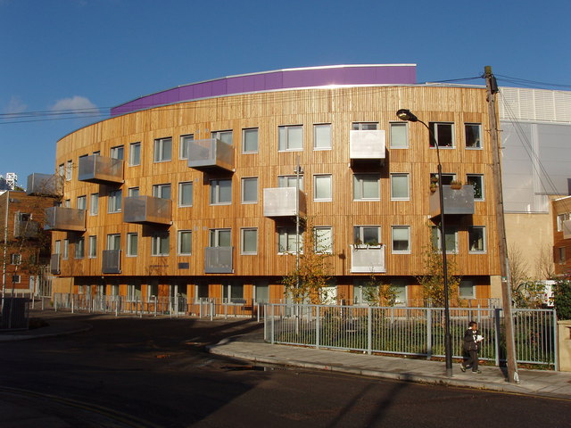
English: Bourbon Lane - award winning development near Westfield Bourbon Lane is a new development on a narrow site between streets of pre-war houses and the new Westfield shopping centre. There are 33 part equity and 45 social rent homes. It was one of five winners for completed schemes in the 2008 Design for Living awards - see http://www.designforhomes.org/hda/2008/complete/bourbon_lane.html . These awards were instigated by Aneurin Bevan in 1947 and have run with varying conditions since then. Hammersmith and Fulham council press release http://www.lbhf.gov.uk/Directory/News_and_Media/Press_office/Press_releases/110421_Bourbon_Lane_cest_magnifique.asp says it has won 9 awards, and was the result of an anglo-french design competition - the architects are Cartwright Pickard Architects and B & C Architectes . |
| Date | |
| Source | From geograph.org.uk |
| Author | David Hawgood |
| Attribution (required by the license) | David Hawgood / Bourbon Lane - award winning development near Westfield / |
| Camera location | | View this and other nearby images on: OpenStreetMap |
|---|
_heading:0.00&language=en)
| Object location | | View this and other nearby images on: OpenStreetMap |
|---|
_heading:0.00&language=en)
Licensing[edit]

|
This image was taken from the Geograph project collection. See this photograph's page on the Geograph website for the photographer's contact details. The copyright on this image is owned by David Hawgood and is licensed for reuse under the Creative Commons Attribution-ShareAlike 2.0 license.
|
This file is licensed under the Creative Commons Attribution-Share Alike 2.0 Generic license.
Attribution: David Hawgood
- You are free:
- to share – to copy, distribute and transmit the work
- to remix – to adapt the work
- Under the following conditions:
- attribution – You must give appropriate credit, provide a link to the license, and indicate if changes were made. You may do so in any reasonable manner, but not in any way that suggests the licensor endorses you or your use.
- share alike – If you remix, transform, or build upon the material, you must distribute your contributions under the same or compatible license as the original.
File history
Click on a date/time to view the file as it appeared at that time.
| Date/Time | Thumbnail | Dimensions | User | Comment | |
|---|---|---|---|---|---|
| current | 03:30, 24 February 2011 | | 640 × 480 (84 KB) | GeographBot (talk | contribs) | == {{int:filedesc}} == {{Information |description={{en|1=Bourbon Lane - award winning development near Westfield Bourbon Lane is a new development on a narrow site between streets of pre-war houses and the new Westfield shopping centre. There are 33 part |
You cannot overwrite this file.
File usage on Commons
There are no pages that use this file.