File:Bottenhavet.png
Jump to navigation
Jump to search
No higher resolution available.
Bottenhavet.png (316 × 380 pixels, file size: 9 KB, MIME type: image/png)
Captions
Captions
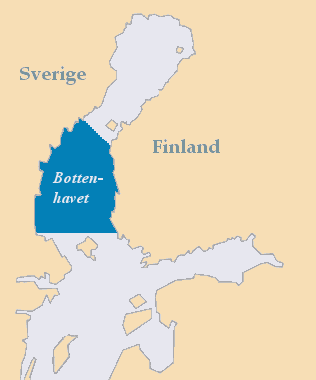
The Bothnian Sea between Sweden and Finland

|
This locator map image could be re-created using vector graphics as an SVG file. This has several advantages; see Commons:Media for cleanup for more information. If an SVG form of this image is available, please upload it and afterwards replace this template with
{{vector version available|new image name}}.
It is recommended to name the SVG file “Bottenhavet.svg”—then the template Vector version available (or Vva) does not need the new image name parameter. |
| Description |
Deutsch: Lage der Bottnischen See zwischen Schweden und Finnland
English: The Bothnian Sea between Sweden and Finland
Suomi: Selkämeri
Svenska: Karta som visar Bottenhavets utsträckning mellan Sverige och Finland |
||
| Date | |||
| Source | Own work | ||
| Author | MoRsE | ||
| Permission (Reusing this file) |
|
File history
Click on a date/time to view the file as it appeared at that time.
| Date/Time | Thumbnail | Dimensions | User | Comment | |
|---|---|---|---|---|---|
| current | 20:15, 18 May 2013 | | 316 × 380 (9 KB) | Hasenläufer (talk | contribs) | crop fixed |
| 19:38, 18 May 2013 |  | 320 × 384 (11 KB) | Hasenläufer (talk | contribs) | border cropped | |
| 19:09, 19 November 2006 |  | 320 × 384 (11 KB) | MoRsE (talk | contribs) | {{PD-self}} The Bothnian Sea --~~~~ |
You cannot overwrite this file.
File usage on Commons
The following page uses this file:
File usage on other wikis
The following other wikis use this file:
- Usage on ar.wikipedia.org
- Usage on ast.wikipedia.org
- Usage on bs.wikipedia.org
- Usage on ckb.wikipedia.org
- Usage on da.wikipedia.org
- Usage on de.wikipedia.org
- Usage on el.wikipedia.org
- Usage on en.wikipedia.org
- Usage on eo.wikipedia.org
- Usage on es.wikipedia.org
- Usage on et.wikipedia.org
- Usage on eu.wikipedia.org
- Usage on fa.wikipedia.org
- Usage on fi.wikipedia.org
- Usage on fr.wikipedia.org
- Usage on gl.wikipedia.org
- Usage on id.wikipedia.org
- Usage on ilo.wikipedia.org
- Usage on is.wikipedia.org
- Usage on ko.wikipedia.org
- Usage on ku.wikipedia.org
- Usage on lv.wikipedia.org
- Usage on mk.wikipedia.org
- Usage on nn.wikipedia.org
- Usage on no.wikipedia.org
- Usage on pl.wikipedia.org
- Usage on pl.wiktionary.org
- Usage on pt.wikipedia.org
- Usage on sh.wikipedia.org
- Usage on sr.wikipedia.org
- Usage on sv.wikipedia.org
- Usage on tr.wikipedia.org
- Usage on ur.wikipedia.org
- Usage on vi.wikipedia.org
- Usage on war.wikipedia.org
- Usage on www.wikidata.org
- Usage on zh-min-nan.wikipedia.org
- Usage on zh.wikipedia.org