File:Boston area income.png
Jump to navigation
Jump to search
No higher resolution available.
Boston_area_income.png (550 × 452 pixels, file size: 163 KB, MIME type: image/png)
Captions
Captions
Add a one-line explanation of what this file represents
From : http://en.wikipedia.org/wiki/Image:Boston_area_income.gif
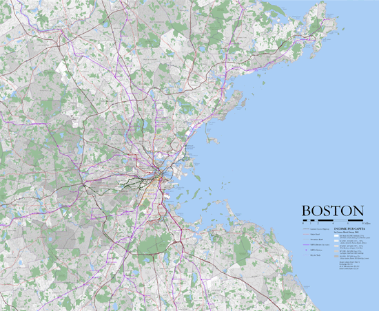
Map showing income per capita in the greater Boston area. Data from the 2000 US census, map from www.radicalcartography.net (where there is a MUCH larger version of this file).
This file is licensed under the Creative Commons Attribution 2.0 Generic license.
- You are free:
- to share – to copy, distribute and transmit the work
- to remix – to adapt the work
- Under the following conditions:
- attribution – You must give appropriate credit, provide a link to the license, and indicate if changes were made. You may do so in any reasonable manner, but not in any way that suggests the licensor endorses you or your use.
Original upload log[edit]
| Date/Time | Dimensions | User | Comment |
|---|---|---|---|
| 19 July 2006, 18:39:35 | 550 × 452 (157847 bytes) | Urban (talk · contribs) | From : http://en.wikipedia.org/wiki/Image:Boston_area_income.gif Map showing income per capita in the greater Boston area. Data from the 2000 US census, map from www.radicalcartography.net (where there is [http://www.radicalcartography.net/?bigboston a M |
File history
Click on a date/time to view the file as it appeared at that time.
| Date/Time | Thumbnail | Dimensions | User | Comment | |
|---|---|---|---|---|---|
| current | 23:55, 24 August 2014 | | 550 × 452 (163 KB) | GifTagger (talk | contribs) | Bot: Converting file to superior PNG file. (Source: Boston_area_income.gif). This GIF was problematic due to non-greyscale color table. |
You cannot overwrite this file.
File usage on Commons
The following page uses this file:
- File:Boston area income.gif (file redirect)
File usage on other wikis
The following other wikis use this file:
- Usage on zh.wikipedia.org