File:Boehm, Plan von Berlin und Umgegend bis Charlottenburg, 1861.jpg
Jump to navigation
Jump to search

Size of this preview: 755 × 599 pixels. Other resolutions: 302 × 240 pixels | 605 × 480 pixels | 968 × 768 pixels | 1,280 × 1,016 pixels | 1,625 × 1,290 pixels.
Original file (1,625 × 1,290 pixels, file size: 1,022 KB, MIME type: image/jpeg)
Captions
Captions
Add a one-line explanation of what this file represents
Summary[edit]
| Title |
Plan von Berlin und Umgegend bis Charlottenburg |
|||||||||
| Description |
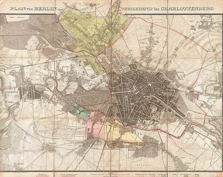
Deutsch: Der Titel steht einzeilig über dem Plan und wird durch eine starke Randüberzeichnung (bis Schäfersee) unterbrochen. Die Karte zeigt in rot die "Bisherige Grenze" und in lila die "Grenze des zulegenden Territorii" der Stadterweiterung von 1861. Die sechs neu hinzugekommenen Gebiete sind koloriert und unter dem Plan in einer Legende benannt. |
|||||||||
| Date | ||||||||||
| Source | Universitäts- und Landesbibliothek Sachsen-Anhalt (online) | |||||||||
| Creator |
Ferdinand Boehm (topografische Aufnahme, Kartografie), gestochen von W. Bembé |
|||||||||
| Geotemporal data | ||||||||||
| Map location | Berlin | |||||||||
| Scale | 1:15,384 | |||||||||
| Heading |
 |
|||||||||
| Bounding box |
|
|||||||||
| Georeferencing | ||||||||||
| Bibliographic data | ||||||||||
| Language | German | |||||||||
| Archival data | ||||||||||
| Collection | Universitäts- und Landesbibliothek Sachsen-Anhalt | |||||||||
| Accession number |
Altkt A III 2/15/24 |
|||||||||
| Dimensions | height: 62 cm (24.4 in); width: 88 cm (34.6 in) | |||||||||
| Medium | steel engraving print | |||||||||
| Notes |
Literatur
|
|||||||||
| Other versions |
|
|||||||||


Licensing[edit]
|
This is a faithful photographic reproduction of a two-dimensional, public domain work of art. The work of art itself is in the public domain for the following reason:
The official position taken by the Wikimedia Foundation is that "faithful reproductions of two-dimensional public domain works of art are public domain".
This photographic reproduction is therefore also considered to be in the public domain in the United States. In other jurisdictions, re-use of this content may be restricted; see Reuse of PD-Art photographs for details. | ||||
File history
Click on a date/time to view the file as it appeared at that time.
| Date/Time | Thumbnail | Dimensions | User | Comment | |
|---|---|---|---|---|---|
| current | 23:33, 15 January 2013 | | 1,625 × 1,290 (1,022 KB) | Alexrk2 (talk | contribs) | {{Information |Description='''Plan von Berlin und Umgegend bis Charlottenburg.''' * Format: 87,9 x 61,1 cm (nur der Plan) * Maßstab: ca 1:15.384 * Lithogr., teilweise koloriert ;Beschreibung Der Titel steht einzeilig über dem Plan und wird durch ein... |
You cannot overwrite this file.
File usage on Commons
The following 5 pages use this file:
.jpg)
File usage on other wikis
The following other wikis use this file:
- Usage on de.wikipedia.org
- Usage on ja.wikipedia.org
- Usage on ko.wikipedia.org