File:BlueLine-ar.jpg
Jump to navigation
Jump to search

Size of this preview: 800 × 553 pixels. Other resolutions: 320 × 221 pixels | 640 × 443 pixels | 1,024 × 708 pixels.
Original file (1,024 × 708 pixels, file size: 226 KB, MIME type: image/jpeg)
Captions
Captions
Add a one-line explanation of what this file represents
Summary[edit]
| Description |
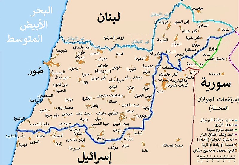
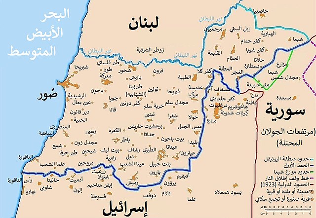
العربية: خريطة توضح الخط الأزرق الفاصل بين لبنان وإسرائيل ، الذي أنشأته الأمم المتحدة بعد الانسحاب الإسرائيلي من جنوب لبنان بعد غزوها القصير عام 1978 والذي أطلق عليه عملية الليطاني. يتبع خط وقف إطلاق النار لعام 1949 ، المعروف أيضًا باسم الخط الأخضر، بالإضافة إلى الحدود اللبنانية السورية المتنازع عليها تجاه مرتفعات الجولان التي تحتلها إسرائيل.
English: Map showing the Blue Line demarcation line between Lebanon and Israel, established by the UN after the Israeli withdrawal from southern Lebanon after its short 1978 invasion called Operation Litani. It follows the 1949 cease-fire line, also known as the Green Line, as well as the somewhat contested Lebanese-Syrian border towards the Israeli-occupied Golan Heights. |
|||||||||||||||||
| Date | ||||||||||||||||||
| Source |
This file was derived from: BlueLine.jpg |
|||||||||||||||||
| Author |
|
|||||||||||||||||
| Other versions |
|
|||||||||||||||||


| This is a retouched picture, which means that it has been digitally altered from its original version. Modifications: Translated to Arabic. The original can be viewed here: BlueLine.jpg:
|
Licensing[edit]
I, the copyright holder of this work, hereby publish it under the following license:
This file is licensed under the Creative Commons Attribution-Share Alike 4.0 International license.
- You are free:
- to share – to copy, distribute and transmit the work
- to remix – to adapt the work
- Under the following conditions:
- attribution – You must give appropriate credit, provide a link to the license, and indicate if changes were made. You may do so in any reasonable manner, but not in any way that suggests the licensor endorses you or your use.
- share alike – If you remix, transform, or build upon the material, you must distribute your contributions under the same or compatible license as the original.
File history
Click on a date/time to view the file as it appeared at that time.
| Date/Time | Thumbnail | Dimensions | User | Comment | |
|---|---|---|---|---|---|
| current | 06:16, 9 May 2021 | | 1,024 × 708 (226 KB) | Michel Bakni (talk | contribs) | Uploaded own work with UploadWizard |
You cannot overwrite this file.
File usage on Commons
The following 2 pages use this file:
File usage on other wikis
The following other wikis use this file:
- Usage on ar.wikipedia.org
- نهر الليطاني
- عملية الليطاني
- الصراع الإسرائيلي اللبناني
- قرار مجلس الأمن التابع للأمم المتحدة رقم 427
- حدود إسرائيل
- تاريخ حزب الله
- اشتباك الناقورة الحدودي
- الخط الزمني للصراع العربي الإسرائيلي
- الاحتلال الإسرائيلي لجنوب لبنان
- ويكيبيديا:ورشة الصور/أرشيف 37
- قرار مجلس الأمن التابع للأمم المتحدة رقم 501
- قرار مجلس الأمن التابع للأمم المتحدة رقم 1525
- Usage on arz.wikipedia.org
- Usage on www.wikidata.org