File:Bligh Bank 2 offshore substation BE 2016.jpg
From Wikimedia Commons, the free media repository
Jump to navigation
Jump to search
Size of this preview: 800 × 452 pixels. Other resolutions: 320 × 181 pixels | 640 × 362 pixels | 1,024 × 579 pixels | 1,280 × 723 pixels | 2,560 × 1,446 pixels | 5,706 × 3,224 pixels.
Original file (5,706 × 3,224 pixels, file size: 3.13 MB, MIME type: image/jpeg)
File information
Structured data
Captions
Summary[edit]
DescriptionBligh Bank 2 offshore substation BE 2016.jpg |
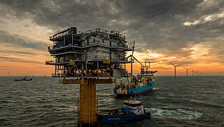
English: BB2 substation platform (BB OHS2) at Nobelwind offshore wind farm (Bligh Bank Phase II) at Bligh Bank off the Belgian coast; MCS Blue Norther service vessel (front), Mærsk Recorder cable layer, and Deep Helder offshore supply ship (background, left) |
||
Date | |||
Source | The Windfarm | ||
Author | Askjell (Askjell Nicolas Raudøy) | ||
Permission (Reusing this file) |
This file is licensed under the Creative Commons Attribution 2.0 Generic license. Attribution: Askjell
|
Camera location | 51° 41′ 26.52″ N, 2° 49′ 31.72″ E | View this and other nearby images on: OpenStreetMap | 51.690700; 2.825478 |
---|
File history
Click on a date/time to view the file as it appeared at that time.
Date/Time | Thumbnail | Dimensions | User | Comment | |
---|---|---|---|---|---|
current | 05:20, 26 September 2023 | 5,706 × 3,224 (3.13 MB) | Beao (talk | contribs) | Cropped 7 % vertically using CropTool with lossless mode. Removed watermark. | |
05:06, 5 January 2019 | 5,706 × 3,484 (2.92 MB) | Te750iv (talk | contribs) | {{Information |description={{en|1=''BB2'' substation platform (BB OHS2) at ''Nobelwind'' offshore wind farm (Bligh Bank Phase II) at Bligh Bank off the Belgian coast; ''MCS Blue Norther'' service vessel (front), ''Mærsk Recorder'' cable layer, and ''Deep Helder'' offshore supply ship (background, left)}} |date=2016-12-07 13:58 |source=[https://www.flickr.com/photos/askjellr/31444843256/ The Windfarm] |author=[https://www.flickr.com/people/askjellr/ Askjell] (Askjell Nicolas Raudøy) |permissio... |
You cannot overwrite this file.
File usage on Commons
The following 3 pages use this file:
File usage on other wikis
The following other wikis use this file:
- Usage on de.wikipedia.org
- Usage on en.wikipedia.org
- Usage on fr.wikipedia.org
- Usage on nl.wikipedia.org
- Usage on uk.wikipedia.org
- Usage on www.wikidata.org
Metadata
This file contains additional information such as Exif metadata which may have been added by the digital camera, scanner, or software program used to create or digitize it. If the file has been modified from its original state, some details such as the timestamp may not fully reflect those of the original file. The timestamp is only as accurate as the clock in the camera, and it may be completely wrong.
Camera manufacturer | Canon |
---|---|
Camera model | Canon EOS 5D Mark III |
Exposure time | 1/640 sec (0.0015625) |
F-number | f/7.1 |
ISO speed rating | 160 |
Date and time of data generation | 13:58, 7 December 2016 |
Lens focal length | 24 mm |
Latitude | 51° 41′ 26.52″ N |
Longitude | 2° 49′ 31.72″ E |
Altitude | 70.3 meters below sea level |
Label | Blue |
Short title |
|
Author | Askjell Raudøy |
Copyright holder |
|
Horizontal resolution | 240 dpi |
Vertical resolution | 240 dpi |
Software used | Adobe Photoshop Lightroom 6.7 (Windows) |
File change date and time | 13:21, 7 December 2016 |
Exposure Program | Manual |
Exif version | 2.3 |
Date and time of digitizing | 13:58, 7 December 2016 |
APEX shutter speed | 9.321928 |
APEX aperture | 5.655638 |
APEX exposure bias | 0 |
Maximum land aperture | 4 APEX (f/4) |
Metering mode | Pattern |
Flash | Flash did not fire |
DateTimeOriginal subseconds | 94 |
DateTimeDigitized subseconds | 94 |
Color space | sRGB |
Focal plane X resolution | 1,600 |
Focal plane Y resolution | 1,600 |
Focal plane resolution unit | 3 |
Custom image processing | Normal process |
Exposure mode | Manual exposure |
White balance | Auto white balance |
Scene capture type | Standard |
GPS time (atomic clock) | 11:58:35.875 |
Satellites used for measurement | 10 |
Receiver status | Measurement in progress |
Measurement mode | 3-dimensional measurement |
Measurement precision | Poor (3.3) |
Speed of GPS receiver | 0 |
Direction of movement | 0 |
Reference for direction of image | Magnetic direction |
Direction of image | 108 |
Geodetic survey data used | WGS-84 |
Bearing of destination | 0 |
Distance to destination | 0 |
GPS date | 7 December 2016 |
GPS differential correction | 0 |
GPS tag version | 0.0.3.2 |
Serial number of camera | 268021013053 |
Lens used | EF24-105mm f/4L IS USM |
Owner of camera | Askjell Raudoy |
Date metadata was last modified | 14:21, 7 December 2016 |
Rating (out of 5) | 3 |
Unique ID of original document | 885D196C19133E4728534C4FE35576C5 |
Copyright status | Copyrighted |
Keywords |
|
Sublocation of city shown | Belgium |
IIM version | 4 |