File:Bitterroot and Teton Ranges (MODIS 2023-12-25).jpg
Jump to navigation
Jump to search

Size of this preview: 734 × 600 pixels. Other resolutions: 294 × 240 pixels | 588 × 480 pixels | 940 × 768 pixels | 1,253 × 1,024 pixels | 2,507 × 2,048 pixels | 4,049 × 3,308 pixels.
Original file (4,049 × 3,308 pixels, file size: 2.32 MB, MIME type: image/jpeg)
Captions
Captions
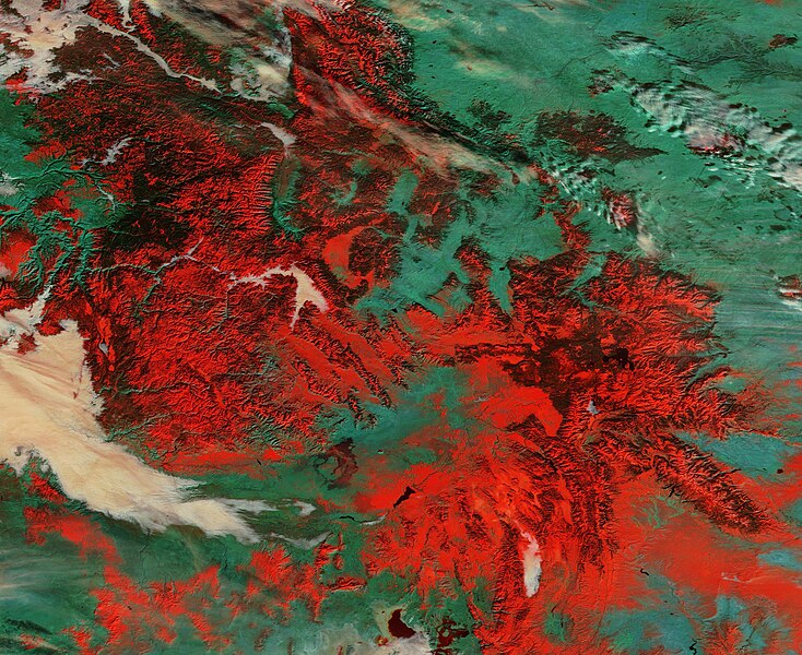
On December 17, 2023, the Moderate Resolution Imaging Spectroradiometer (MODIS) on NASA’s Terra satellite acquired a false-color image of snow atop the high ranges of the Bitterroot and Teton Ranges in the Western United States.
Summary[edit]
.jpg&action=edit§ion=1)
| Description |
English: On December 17, 2023, the Moderate Resolution Imaging Spectroradiometer (MODIS) on NASA’s Terra satellite acquired a false-color image of snow atop the high ranges of the Bitterroot and Teton Ranges in the Western United States.
This type of image uses a combination of visible light and shortwave infrared (MODIS bands 3,6,7) to separate snow and ice (bright red) from vegetation (green). The thicker the snow or ice, the more light is absorbed, the more robust the red will appear. Cloud and fog (low cloud) looks white, except for very cold clouds that contain ice particles, which will take on a red tint. Both the Bitterroot Range and the Teton Mountains are subranges of the Rocky Mountains. The Tetons (in the southeast) stretch about 40 miles (64 km) in a north-south direction through the state of Wyoming and east of the border with Idaho. Most of the eastern section of the range lies within Grand Teton National Park. The Bitterroot Range sprawls across part of Idaho and Montana, spanning about 24,223 square miles (62,740 square kilometers). It takes its name from the state flower of Montana, a small, pink flower known as the bitterroot. |
||
| Date | Taken on 17 December 2023 | ||
| Source |
Bitterroot and Teton Ranges (direct link)
|
||
| Author | MODIS Land Rapid Response Team, NASA GSFC |
| This media is a product of the Terra mission Credit and attribution belongs to the mission team, if not already specified in the "author" row |
Licensing[edit]
.jpg&action=edit§ion=2)
| This file is in the public domain in the United States because it was solely created by NASA. NASA copyright policy states that "NASA material is not protected by copyright unless noted". (See Template:PD-USGov, NASA copyright policy page or JPL Image Use Policy.) | ||
 |
Warnings:
|
File history
Click on a date/time to view the file as it appeared at that time.
| Date/Time | Thumbnail | Dimensions | User | Comment | |
|---|---|---|---|---|---|
| current | 05:05, 26 December 2023 | | 4,049 × 3,308 (2.32 MB) | OptimusPrimeBot (talk | contribs) | #Spacemedia - Upload of http://modis.gsfc.nasa.gov/gallery/images/image12252023_250m.jpg via Commons:Spacemedia |
You cannot overwrite this file.
File usage on Commons
There are no pages that use this file.
.jpg&oldid=835245840)