File:BirchwylerstrBassersdorfIII.jpg
Jump to navigation
Jump to search

Size of this preview: 800 × 580 pixels. Other resolutions: 320 × 232 pixels | 640 × 464 pixels | 1,024 × 743 pixels | 1,280 × 929 pixels | 2,560 × 1,857 pixels | 3,301 × 2,395 pixels.
Original file (3,301 × 2,395 pixels, file size: 5.08 MB, MIME type: image/jpeg)
Captions
Captions
Add a one-line explanation of what this file represents
Summary[edit]
| Description |
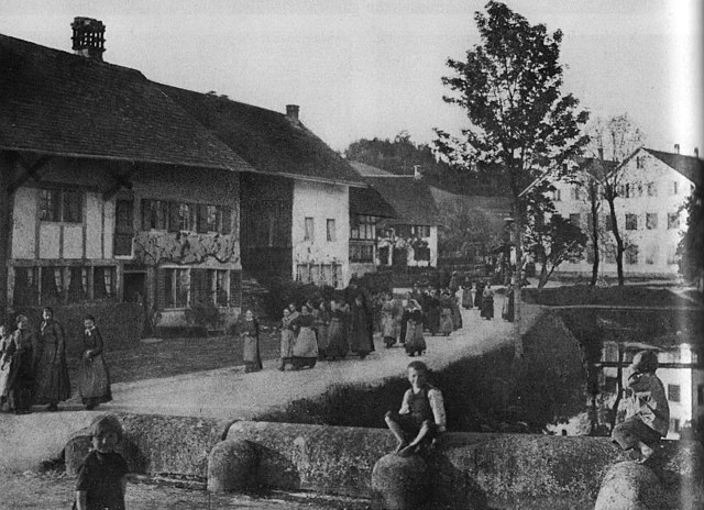
Deutsch: Blick um 1900 von der Hůbbrücke über dem Altbache zů Baſſersdorf auf die Birchwylerſtraß mit Arbeiterinnen der Seidenwinderey auf dem Heimwege. Rechts im Hintergrunde die am 2. Februar 1912 verbrunnene Druckerey und Machinen-Fabrique am Standort der 1891 durch Brand zerſtörten Untern Mühle; die Häußer links im Bild wurden 2003 abgebrochen und durch Neubauten ersetzt.
English: Birchwyl Road at Baſſersdorf around 1900 with Silk Mill Workers going home; to the right in the backdrop the Printing Shop and Machine Factory which had been built at the place of a Mill burnt down in 1891, and that eventually got deſtroyed by Fire as well on 2nd February 1912. The Houses to the left were demoliſhed in 2003 for new Buildings. |
|||
| Date | circa 1900 | |||
| Source | Erika Zweifel, Baſſersdorf im Wandel der Zeit, Baſſersdorf 1986, p. 66. | |||
| Author | Unknown author | |||
| Permission (Reusing this file) |
|
| Camera location | | View this and other nearby images on: OpenStreetMap |
|---|
File history
Click on a date/time to view the file as it appeared at that time.
| Date/Time | Thumbnail | Dimensions | User | Comment | |
|---|---|---|---|---|---|
| current | 07:43, 31 July 2013 | | 3,301 × 2,395 (5.08 MB) | Abderitestatos (talk | contribs) | == {{int:filedesc}} == {{Information |Description= {{de|Blick von der Hůbbrücke über dem Altbache zů Baſſersdorf auf die Birchwylerſtraß mit Arbeiterinnen der Seidenwinderey auf dem Heimwege; rechts im Hintergrunde die am 2. Februar 1912 verbru... |
You cannot overwrite this file.
File usage on Commons
There are no pages that use this file.
Metadata
Categories:
- Altbach (Glatt)
- Buildings destroyed by fire in Switzerland
- Demolished buildings in Bassersdorf
- Destroyed in 1912
- Destroyed in 2003
- Factories in Switzerland
- Historical black and white photographs of Bassersdorf
- Houses at Birchwilerstraße in Bassersdorf
- Silk workers
- Workers in Switzerland
- Switzerland in the 1900s