File:Bhor Ghat Karte.png
Jump to navigation
Jump to search

Size of this preview: 331 × 599 pixels. Other resolutions: 132 × 240 pixels | 265 × 480 pixels | 987 × 1,787 pixels.
Original file (987 × 1,787 pixels, file size: 657 KB, MIME type: image/png)
Captions
Captions
Add a one-line explanation of what this file represents
Summary
[edit]
| Description |
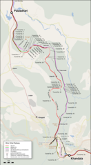
Deutsch: Lagekarte der Bhor Ghat Railway in Indien English: Location map of the Bhor Ghat Railway in India. Index in Germand |
| Date | |
| Source |
Map was created using: |
| Author |
|
| Permission (Reusing this file) |
|
Licensing
[edit]
I, the copyright holder of this work, hereby publish it under the following license:
This file is licensed under the Creative Commons Attribution-Share Alike 3.0 Unported license.
Attribution: Peter Christener
- You are free:
- to share – to copy, distribute and transmit the work
- to remix – to adapt the work
- Under the following conditions:
- attribution – You must give appropriate credit, provide a link to the license, and indicate if changes were made. You may do so in any reasonable manner, but not in any way that suggests the licensor endorses you or your use.
- share alike – If you remix, transform, or build upon the material, you must distribute your contributions under the same or compatible license as the original.
| This work is licensed under the Open Database License (summary). |
File history
Click on a date/time to view the file as it appeared at that time.
| Date/Time | Thumbnail | Dimensions | User | Comment | |
|---|---|---|---|---|---|
| current | 10:56, 4 January 2018 | | 987 × 1,787 (657 KB) | Pechristener (talk | contribs) | einige Korrekturen und ergänzungen |
| 22:50, 2 January 2018 |  | 987 × 1,787 (639 KB) | Pechristener (talk | contribs) | {{Information |Description={{de|Lagekarte der Bhor Ghat Railway in Indien}}{{en|Location map of the Bhor Ghat Railway in India. Index in Germand}} |Source= Map was created using: *[http://www.openstreetmap.org/ Open Street Map] |Author= *Open Street... |
You cannot overwrite this file.
File usage on Commons
There are no pages that use this file.
File usage on other wikis
The following other wikis use this file:
- Usage on de.wikipedia.org