File:Belgian Heritage Railway Line 58.png
Jump to navigation
Jump to search
Size of this preview: 800 × 453 pixels. Other resolutions: 320 × 181 pixels | 819 × 464 pixels.
Original file (819 × 464 pixels, file size: 254 KB, MIME type: image/png)
Captions
Captions
Add a one-line explanation of what this file represents
Summary
[edit]
| Description |
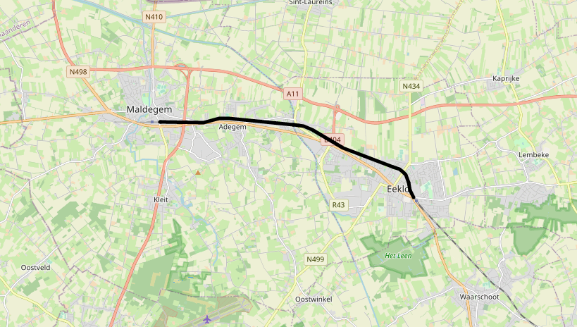
English: Heritage part of Belgian Railway Line 58 |
| Date | |
| Source | openstreetmap.org |
| Author | OpenStreetMap contributors |
Licensing
[edit]
| Description |
This map was created from OpenStreetMap project data, collected by the community. This map may be incomplete, and may contain errors. Don't rely solely on it for navigation. |
|||
| Date | ||||
| Source | openstreetmap.org | |||
| Creator |
OpenStreetMap contributors |
|||
| Permission (Reusing this file) |
OpenStreetMap data is available under the Open Database License (details). Standard style map tiles are licensed as ODbL Produced Works.
|
|||
| Georeferencing | If inappropriate please set warp_status = skip to hide. |
File history
Click on a date/time to view the file as it appeared at that time.
| Date/Time | Thumbnail | Dimensions | User | Comment | |
|---|---|---|---|---|---|
| current | 15:38, 7 May 2023 | | 819 × 464 (254 KB) | M!dgard (talk | contribs) | Uploaded a work by OpenStreetMap contributors from openstreetmap.org with UploadWizard |
You cannot overwrite this file.
File usage on Commons
The following 2 pages use this file:
File usage on other wikis
The following other wikis use this file:
- Usage on www.wikidata.org