File:Belfast City Council Election, 2019 (District Electoral Areas Results).svg
Jump to navigation
Jump to search

Size of this PNG preview of this SVG file: 800 × 500 pixels. Other resolutions: 320 × 200 pixels | 640 × 400 pixels | 1,024 × 640 pixels | 1,280 × 800 pixels | 2,560 × 1,600 pixels.
Original file (SVG file, nominally 800 × 500 pixels, file size: 451 KB)
Captions
Captions
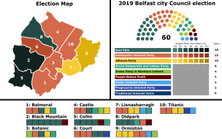
Map of the 2019 Belfast City Council election
Summary[edit]
.svg&action=edit§ion=1)
| Description |
English: Map of results for the Belfast City Council Election, 2014. Each district electoral area is shaded in by the largest party in first preference votes share for that district. Each DEA makeup of seats are shown by the side. Parties SF: 18 seats
DUP: 15 seats
ALL: 10 seats
SDLP: 6 seats
Green: 4 seat
PBP: 3 seat
UUP: 2 seats
PUP: 2 seats |
| Date | |
| Source | Own work |
| Author | MrPenguin21 |
| Permission (Reusing this file) |
This file was derived from: Belfast City Council Election, 2014 (District Electoral Areas Results).svg: by JDuggan101 |
.svg)
Licensing[edit]
.svg&action=edit§ion=2)
I, the copyright holder of this work, hereby publish it under the following license:
This file is licensed under the Creative Commons Attribution-Share Alike 4.0 International license.
- You are free:
- to share – to copy, distribute and transmit the work
- to remix – to adapt the work
- Under the following conditions:
- attribution – You must give appropriate credit, provide a link to the license, and indicate if changes were made. You may do so in any reasonable manner, but not in any way that suggests the licensor endorses you or your use.
- share alike – If you remix, transform, or build upon the material, you must distribute your contributions under the same or compatible license as the original.
File history
Click on a date/time to view the file as it appeared at that time.
| Date/Time | Thumbnail | Dimensions | User | Comment | |
|---|---|---|---|---|---|
| current | 22:46, 6 May 2019 | | 800 × 500 (451 KB) | MrPenguin21 (talk | contribs) | User created page with UploadWizard |
You cannot overwrite this file.
File usage on Commons
The following page uses this file:
.svg&oldid=850105910)