File:Begby danseren 2018-09-07-0001.jpg
Original file (3,560 × 5,600 pixels, file size: 10.5 MB, MIME type: image/jpeg)
Captions
Summary[edit]
DescriptionBegby danseren 2018-09-07-0001.jpg |
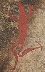
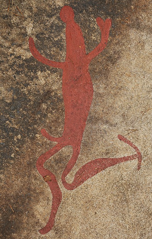
English: Rock art from Begby in Fredrikstad, Norway. The danser, a carving in a group of at least 65 figures. Heigth 70 cm. |
Date | |
Source | Own work |
Author | Hans A. Rosbach |
Camera location | 59° 13′ 11.8″ N, 11° 00′ 26.02″ E | View this and other nearby images on: OpenStreetMap | 59.219945; 11.007228 |
---|
Licensing[edit]
- You are free:
- to share – to copy, distribute and transmit the work
- to remix – to adapt the work
- Under the following conditions:
- attribution – You must give appropriate credit, provide a link to the license, and indicate if changes were made. You may do so in any reasonable manner, but not in any way that suggests the licensor endorses you or your use.
- share alike – If you remix, transform, or build upon the material, you must distribute your contributions under the same or compatible license as the original.
This is a photo of a monument in Norway, number: 9801 in the Norwegian Directorate for Cultural Heritage database.
|
This image was uploaded as part of Wiki Loves Monuments 2018.
Afrikaans ∙ Alemannisch ∙ azərbaycanca ∙ Bahasa Indonesia ∙ Bahasa Melayu ∙ Bikol Central ∙ bosanski ∙ brezhoneg ∙ català ∙ čeština ∙ Cymraeg ∙ dansk ∙ davvisámegiella ∙ Deutsch ∙ eesti ∙ English ∙ español ∙ Esperanto ∙ euskara ∙ français ∙ Frysk ∙ Gaeilge ∙ galego ∙ hrvatski ∙ Ido ∙ italiano ∙ latviešu ∙ Lëtzebuergesch ∙ Malagasy ∙ magyar ∙ Malti ∙ Nederlands ∙ norsk ∙ norsk nynorsk ∙ norsk bokmål ∙ polski ∙ português ∙ português do Brasil ∙ română ∙ shqip ∙ sicilianu ∙ slovenčina ∙ slovenščina ∙ suomi ∙ svenska ∙ Tagalog ∙ Türkçe ∙ Yorùbá ∙ Zazaki ∙ Ελληνικά ∙ беларуская ∙ беларуская (тарашкевіца) ∙ български ∙ кыргызча ∙ македонски ∙ русский ∙ српски / srpski ∙ українська ∙ ქართული ∙ հայերեն ∙ नेपाली ∙ हिन्दी ∙ বাংলা ∙ മലയാളം ∙ ไทย ∙ 한국어 ∙ +/− |
File history
Click on a date/time to view the file as it appeared at that time.
Date/Time | Thumbnail | Dimensions | User | Comment | |
---|---|---|---|---|---|
current | 06:57, 2 October 2018 | 3,560 × 5,600 (10.5 MB) | Haros (talk | contribs) | ||
10:38, 30 September 2018 | 3,840 × 5,760 (11.63 MB) | Haros (talk | contribs) | VicuñaUploader 1.23 |
You cannot overwrite this file.
File usage on Commons
The following page uses this file:
File usage on other wikis
The following other wikis use this file:
- Usage on no.wikipedia.org
Metadata
This file contains additional information such as Exif metadata which may have been added by the digital camera, scanner, or software program used to create or digitize it. If the file has been modified from its original state, some details such as the timestamp may not fully reflect those of the original file. The timestamp is only as accurate as the clock in the camera, and it may be completely wrong.
Camera manufacturer | Canon |
---|---|
Camera model | Canon EOS 5D Mark III |
Author | Hans A. Rosbach |
Copyright holder | License: CC-BY-SA 3.0 |
Exposure time | 1/160 sec (0.00625) |
F-number | f/5.6 |
ISO speed rating | 100 |
Date and time of data generation | 13:33, 7 September 2018 |
Lens focal length | 95 mm |
Latitude | 59° 13′ 11.8″ N |
Longitude | 11° 0′ 26.02″ E |
Altitude | 27.4 meters above sea level |
Orientation | Normal |
Horizontal resolution | 72 dpi |
Vertical resolution | 72 dpi |
File change date and time | 08:56, 2 October 2018 |
Y and C positioning | Co-sited |
Exposure Program | Normal program |
Exif version | 2.3 |
Date and time of digitizing | 13:33, 7 September 2018 |
Meaning of each component |
|
APEX shutter speed | 7.375 |
APEX aperture | 5 |
APEX exposure bias | −0.66666666666667 |
Metering mode | Pattern |
Flash | Flash did not fire |
DateTime subseconds | 62 |
DateTimeOriginal subseconds | 62 |
DateTimeDigitized subseconds | 62 |
Supported Flashpix version | 1 |
Color space | sRGB |
Focal plane X resolution | 3,942.5051334702 |
Focal plane Y resolution | 3,950.6172839506 |
Focal plane resolution unit | inches |
Custom image processing | Normal process |
Exposure mode | Auto exposure |
White balance | Manual white balance |
Scene capture type | Standard |
GPS time (atomic clock) | 11:33 |
Satellites used for measurement | 12 |
Receiver status | Measurement in progress |
Measurement mode | 3-dimensional measurement |
Measurement precision | Poor (2.1) |
Speed of GPS receiver | 0 |
Direction of movement | 0 |
Reference for direction of image | Magnetic direction |
Direction of image | 222 |
Geodetic survey data used | WGS-84 |
Bearing of destination | 0 |
Distance to destination | 0 |
GPS date | 7 September 2018 |
GPS differential correction | 0 |
GPS tag version | 0.0.3.2 |
Image width | 3,840 px |
Image height | 5,760 px |
Name of GPS processing method | 256 bytes undefined data |
Name of GPS area | 256 bytes undefined data |
Structured data
Items portrayed in this file
depicts
7 September 2018
59°13'11.802"N, 11°0'26.021"E
image/jpeg
543309b4bbf08f9078b4121a80410d1eadd0ebeb
11,010,405 byte
5,600 pixel
3,560 pixel
- CC-BY-SA-3.0
- Self-published work
- Cultural heritage monuments in Norway with known IDs
- Images from Wiki Loves Monuments 2018
- Images from Wiki Loves Monuments 2018 in Norway
- Images from Wiki Loves Monuments missing SDC creator
- Pictures by User:Haros
- Uploaded with VicuñaUploader
- Norway photographs taken on 2018-09-07
- Pages with maps