File:Beechworth Mental Hospital - May Day Hills Asylum - The Lion of Beechworth.jpg
Original file (960 × 716 pixels, file size: 81 KB, MIME type: image/jpeg)
Captions
Captions
Summary[edit]
| Description |
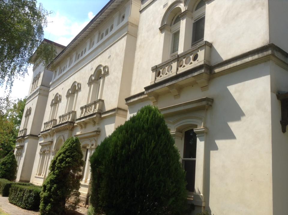
English: In October 1867, following lobbying by the Beechworth Municipal Council, the Beechworth Asylum opened for the reception of patients. Its proclamation as an Asylum was published in the Government Gazette on 1 October 1867 under the provisions of the Lunacy Statute 1867 (No.309).
Patients had previously been confined to the town's gaol due to lack of more appropriate accommodation. As the first patients were admitted, the men were put to work as farm labourers, carpenters, blacksmiths, painters, shoe-makers and tailors, while the women worked as launderers, knitters, seamstresses and domestics. From 1880, records indicate that recreational activities were introduced. In the ensuing years, additional buildings were added to meet demand for patients to be placed in the area. Since its establishment, the title of the institution at Beechworth has been altered several times to reflect both the community's changing attitude towards mental illness and the Victorian Government's approach to the treatment of mentally disturbed persons. Despite the changes in designation, the function and structure of the agency has not altered significantly. Therefore, the institution has been registered as one continuous agency. From its establishment until 1905, the institution at Beechworth was known as an Asylum. This title emphasised its function as a place of detention rather than a hospital which provided treatment for mentally ill people who could be cured. The Lunacy Act 1903 (No.1873) changed the title of all "asylums" to "hospitals for the insane". This Act came into operation in March 1905. The Mental Hygiene Act 1933 (No.4157) altered the title to "mental hospitals, and the institution operated as Beechworth Mental Hospital from 1934-1967. In 1938, the Wangaratta Ladies Auxiliary formed and community members took an active role contributing to patients' comforts and interests. In 1952, the Mental Health Authority established the Open Door policy, demolishing the perimeter wall in 1955. By the 1960s, a Nurse Training School and adjacent Nurses' Home had been established at the hospital, leading to major developments in nursing education. In 1962, the Mental Retardation and Mental Hospital sections were officially separated. In 1964, several wards were renovated, renamed and re-opened as a Training Centre specifically to care for and train more than 200 people with intellectual disabilities. Beechworth Training Centre operated within the institution from 1964-1990. In 1967 the institution at Beechworth became widely known as "Mayday Hills Hospital" which included the Mental Hospital (1967-1991)and Psychiatric Hospital (1978-1995). In 1977, the Psychiatric Hospital was proclaimed under the Mental Health Act 1959. In the late 1980s and early 1990s, the development of other residential options (day placements, education, employment, and recreational opportunities) meant there were fewer clients. By 1992, all intellectual disability clients had been removed from the hospital and placed in other forms of accommodation. By 1993, the Psychiatric Hospital had a capacity of 130 beds, with only 20 available for acute adult patients and more than 70 for geriatric patients. By 1996, the Hospital consisted of two psycho-geriatric wards (Emerald and Amethyst), the Kerferd Acute Clinic, Willow, and external housing at Gilchrest Avenue and Mayday Court. The process of decommissioning was underway and that year the site was added to the Register of Historic Buildings. In c.1996 the Mayday Hills institution closed and psychiatric patient services moved to Beechworth Hospital.
|
||
| Date | |||
| Source | Own work | ||
| Author | JacsWiki |
| Camera location | | View this and other nearby images on: OpenStreetMap |
|---|
Image Collection *photographs are my own* <https://www.youtube.com/watch?v=M_g9xbUkY9A&feature=youtu.be>
Victorian Heritage Database <http://vhd.heritagecouncil.vic.gov.au/places/96>
<Public Records of Victoria : Agency VA 2842 <http://access.prov.vic.gov.au/public/component/daPublicBaseContainer?component=daViewAgency&breadcrumbPath=Home/Access%20the%20Collection/Browse%20The%20Collection/Agency%20Details&entityId=2842#>
Licensing[edit]
- You are free:
- to share – to copy, distribute and transmit the work
- to remix – to adapt the work
- Under the following conditions:
- attribution – You must give appropriate credit, provide a link to the license, and indicate if changes were made. You may do so in any reasonable manner, but not in any way that suggests the licensor endorses you or your use.
- share alike – If you remix, transform, or build upon the material, you must distribute your contributions under the same or compatible license as the original.

|
This image was uploaded as part of Wiki Loves Monuments 2017.
|
 |
File history
Click on a date/time to view the file as it appeared at that time.
| Date/Time | Thumbnail | Dimensions | User | Comment | |
|---|---|---|---|---|---|
| current | 22:40, 16 September 2017 | | 960 × 716 (81 KB) | JacsWiki (talk | contribs) | User created page with UploadWizard |
You cannot overwrite this file.
File usage on Commons
There are no pages that use this file.