File:Beddington, Hilliers Lane - geograph.org.uk - 1777430.jpg
Jump to navigation
Jump to search

Size of this preview: 800 × 533 pixels. Other resolutions: 320 × 213 pixels | 640 × 427 pixels | 1,024 × 683 pixels | 1,280 × 853 pixels | 2,560 × 1,707 pixels | 3,456 × 2,304 pixels.
Original file (3,456 × 2,304 pixels, file size: 5.01 MB, MIME type: image/jpeg)
Captions
Captions
Add a one-line explanation of what this file represents
Summary[edit]
| Description |
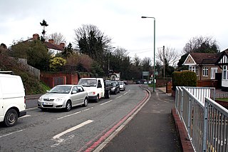
English: Beddington: Hilliers Lane Looking north from the barrier which closes off Hallowell Avenue. Hilliers Lane is part of the B272, and is very busy all day. It gives access to Beddington Lane and thence to a large number of industrial premises, to the Asda superstore, and is also used as a 'cut through' to Mitcham by motorists. Pedestrians trying to cross Hilliers Lane take their lives in their hands, unless they cross by the traffic lights. |
| Date | |
| Source | From geograph.org.uk |
| Author | Dr Neil Clifton |
| Attribution (required by the license) | Dr Neil Clifton / Beddington: Hilliers Lane / |
| Camera location | | View this and other nearby images on: OpenStreetMap |
|---|
_heading:22.00&language=en)
| Object location | | View this and other nearby images on: OpenStreetMap |
|---|
_heading:22.00&language=en)
Licensing[edit]

|
This image was taken from the Geograph project collection. See this photograph's page on the Geograph website for the photographer's contact details. The copyright on this image is owned by Dr Neil Clifton and is licensed for reuse under the Creative Commons Attribution-ShareAlike 2.0 license.
|
This file is licensed under the Creative Commons Attribution-Share Alike 2.0 Generic license.
Attribution: Dr Neil Clifton
- You are free:
- to share – to copy, distribute and transmit the work
- to remix – to adapt the work
- Under the following conditions:
- attribution – You must give appropriate credit, provide a link to the license, and indicate if changes were made. You may do so in any reasonable manner, but not in any way that suggests the licensor endorses you or your use.
- share alike – If you remix, transform, or build upon the material, you must distribute your contributions under the same or compatible license as the original.
File history
Click on a date/time to view the file as it appeared at that time.
| Date/Time | Thumbnail | Dimensions | User | Comment | |
|---|---|---|---|---|---|
| current | 22:32, 11 March 2011 | | 3,456 × 2,304 (5.01 MB) | GeographBot (talk | contribs) | == {{int:filedesc}} == {{Information |description={{en|1=Beddington: Hilliers Lane Looking north from the barrier which closes off Hallowell Avenue. Hilliers Lane is part of the B272, and is very busy all day. It gives access to Beddington Lane and the |
You cannot overwrite this file.
File usage on Commons
There are no pages that use this file.