File:BaytJibrin.jpg
Jump to navigation
Jump to search

Size of this preview: 800 × 459 pixels. Other resolutions: 320 × 183 pixels | 640 × 367 pixels | 900 × 516 pixels.
Original file (900 × 516 pixels, file size: 101 KB, MIME type: image/jpeg)
Captions
Captions
Add a one-line explanation of what this file represents
Summary[edit]
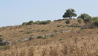
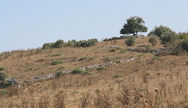
| Description | The ruins of Bayt Jibrin, 2005 |
| Date | 1 August 2005 (original upload date) |
| Source | No machine-readable source provided. Own work assumed (based on copyright claims). |
| Author | No machine-readable author provided. Zero0000 assumed (based on copyright claims). |
Licensing[edit]
Zero0000, the copyright holder of this work, hereby publishes it under the following license:
| I, the copyright holder of this work, release this work into the public domain. This applies worldwide. In some countries this may not be legally possible; if so: I grant anyone the right to use this work for any purpose, without any conditions, unless such conditions are required by law. |
Remnants of former Palestinian village of Bayt Jibrin, destroyed in 1949. The Israeli town of Beit Guivrin was established nearby. The sabra (prickly-pear) cactus in the picture is a frequent feature of old Arab villages since it was used as a fence. This location is inside the green line, south-east of Jerusalem.
This photograph was taken by myself In July 2005 and is put into the public domain.
File history
Click on a date/time to view the file as it appeared at that time.
| Date/Time | Thumbnail | Dimensions | User | Comment | |
|---|---|---|---|---|---|
| current | 12:51, 1 August 2005 | | 900 × 516 (101 KB) | Zero0000 (talk | contribs) | Remnants of former Palestinian village of Bayt Jibrin, destroyed in 1949. |
You cannot overwrite this file.
File usage on Commons
The following page uses this file:
File usage on other wikis
The following other wikis use this file:
- Usage on ar.wikipedia.org
- Usage on arz.wikipedia.org
- Usage on azb.wikipedia.org
- Usage on ca.wikipedia.org
- Usage on da.wikipedia.org
- Usage on de.wikipedia.org
- Usage on de.wikivoyage.org
- Usage on en.wikipedia.org
- Usage on es.wikipedia.org
- Usage on fa.wikipedia.org
- Usage on fi.wikipedia.org
- Usage on fr.wikipedia.org
- Usage on id.wikipedia.org
- Usage on it.wikipedia.org
- Usage on ja.wikipedia.org
- Usage on ms.wikipedia.org
- Usage on pl.wikipedia.org
- Usage on pnb.wikipedia.org
- Usage on ro.wikipedia.org
- Usage on ur.wikipedia.org
- Usage on www.wikidata.org
- Usage on zh.wikipedia.org