File:Battle of the Canal du Nord - Intellligence Target Map (25 Sept 1918).jpg
Jump to navigation
Jump to search

Size of this preview: 800 × 529 pixels. Other resolutions: 320 × 212 pixels | 640 × 423 pixels | 1,024 × 677 pixels | 1,280 × 846 pixels | 2,560 × 1,693 pixels | 20,553 × 13,592 pixels.
Original file (20,553 × 13,592 pixels, file size: 49.69 MB, MIME type: image/jpeg)
Captions
Captions
Add a one-line explanation of what this file represents
| Warning | The original file is very high-resolution. It might not load properly or could cause your browser to freeze when opened at full size. |
|---|
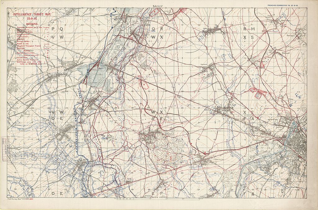
| Title |
English: Sailly: Intelligence target map, 25-9-18 |
||||||||||||||||||||
| Description |
English: Sheet number: part of Sheet 51. Canal du Nord, Hindenburg Line and Marquion Line, 1918; trench, counter-battery and Intelligence target map. "Trenches corrected to 22-9-18." "[1st] Field Survey Battn 6941 (numbers crossed out and replaced with red overprint) 6961." Detail and grid grey; contours ochre; pale blue water. Approximate British Front Line in dark blue. Shows all trenches in blue, including the German positions of the Hindenburg Line, Canal du Nord Line and Marquion Line. |
||||||||||||||||||||
| Date | |||||||||||||||||||||
| Source | McMaster University Research Collections; Fonds: WW1 Trench Maps: France, Box no. 11, envelope no. 015, database no. 334 | ||||||||||||||||||||
| Creator |
Field Service Battalion, Royal Engineers |
||||||||||||||||||||
| Permission (Reusing this file) |
|
||||||||||||||||||||
| Geotemporal data | |||||||||||||||||||||
| Map location | Sailly, Sauchy-Cauchy, Buissy, Bourlon, Cambrai | ||||||||||||||||||||
| Map type | trench map | ||||||||||||||||||||
| Scale | 1:20,000 | ||||||||||||||||||||
| Heading |
 |
||||||||||||||||||||
| Bounding box |
|
||||||||||||||||||||
| Georeferencing | |||||||||||||||||||||
| Bibliographic data | |||||||||||||||||||||
| Map sheet | 51 | ||||||||||||||||||||
| Language | English | ||||||||||||||||||||
| Publisher |
Royal Engineers |
||||||||||||||||||||
| Archival data | |||||||||||||||||||||
| Collection |
|
||||||||||||||||||||
| Accession number |
PC0644 |
||||||||||||||||||||


File history
Click on a date/time to view the file as it appeared at that time.
| Date/Time | Thumbnail | Dimensions | User | Comment | |
|---|---|---|---|---|---|
| current | 13:06, 25 March 2016 | | 20,553 × 13,592 (49.69 MB) | Labattblueboy (talk | contribs) | higher resolution |
| 13:58, 8 June 2009 |  | 5,165 × 3,353 (2.55 MB) | Labattblueboy (talk | contribs) | {{Information |Description= High Resolution Intellligence Map [1:20,000]. Light linen backing. Trenches corrected to 25-9-18. Contours and water features show in colour; Shows the approximate location of the british front line. Sheet numbers: 51b SE, 51a |
You cannot overwrite this file.
File usage on Commons
The following page uses this file:
.jpg&oldid=818695445)