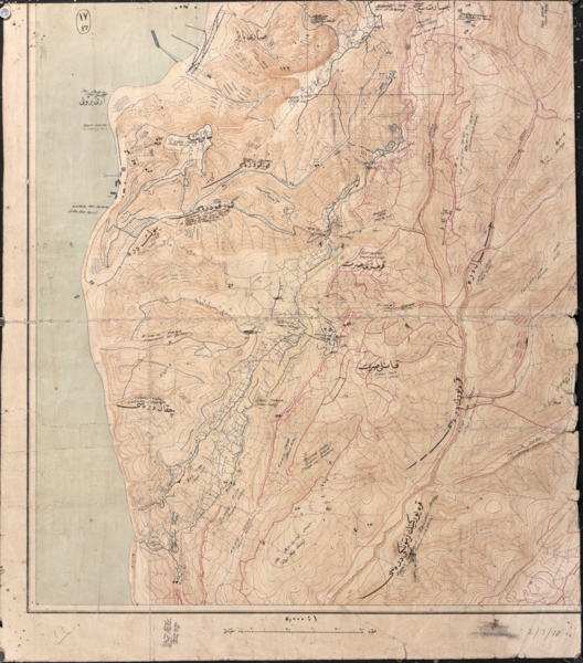
File:Battle of Gallipoli - Turkish map of ANZAC area.png
From Wikimedia Commons, the free media repository
Jump to navigation
Jump to search

Size of this preview: 528 × 600 pixels. Other resolutions: 211 × 240 pixels | 423 × 480 pixels | 676 × 768 pixels | 901 × 1,024 pixels | 1,803 × 2,048 pixels | 4,159 × 4,724 pixels.
Original file (4,159 × 4,724 pixels, file size: 48.46 MB, MIME type: image/png)
File information
Structured data
Captions
Captions
Add a one-line explanation of what this file represents
This PNG image has a thumbnail version at File: Battle of Gallipoli - Turkish map of ANZAC area.jpg.
Generally, the thumbnail version should be used when displaying the file from Commons, in order to reduce the file size of thumbnail images. Any edits to the image should be based on this PNG version in order to prevent generational loss, and both versions should be updated. See here for more information.العربية ∙ Deutsch ∙ English ∙ français ∙ português ∙ suomi ∙ македонски ∙ русский ∙ മലയാളം ∙ +/− |  |
| DescriptionBattle of Gallipoli - Turkish map of ANZAC area.png |
English: This map is one of 43 covering the Gallipoli peninsula, surveyed by The Turkish Mapping Directorate, under Brigadier General Mehmet Şevki Paşa, after the evacuation of Gallipoli in December 1915 and January 1916. British fortifications are shown in blue, Turkish fortifications in red. Place names were printed in Ottoman Turkish, with English translations added in later. The Turks naturally had different names for places at ANZAC than those used by the Australians and New Zealanders. Quinn’s Post was called Bomba Sirt, meaning “bomb spur”, because of all the bombs thrown there owing to the closeness of the trenches; Plugge’s Plateau was called Khain Sirt, which means “cruel or traitorous hill” (called Khan Sirt on the map, which is translated as “ruthless enemy hill”); Walker’s Ridge was called Sercha Tepe, meaning “sparrow hill” (or “sparrow head”); and Shrapnel Valley was called Kuruku Dere, meaning “valley of fear”. Some of the map’s interesting features include the several Christian cemeteries, the Indian Muslim cemetery, and three Turkish cemeteries. While some still remain in the same positions today, others were moved or remodelled in the 1920s. For example, the current Lone Pine cemetery was established after the war, on the position of the old trench lines, many of which were filled in to stabilise the ground. Unburied remains, isolated graves and other cemeteries at risk of erosion were moved to create the cemeteries we know today. Above Ari Burnu are the piers established on North Beach. At the end of the first pier above Ari Burnu (called Williams Pier by the Australians and New Zealanders) is shown the ship, the Milo, which was grounded to act as a breakwater. Leading from the piers are tramways, which were used to move supplies from the piers to ANZAC Cove. Further south on Anzac Cove the map shows four grounded boats. One of these, a steel lifeboat from HMT Ascot was removed from ANZAC Cove in 1921 for the Memorial’s collection; it is now on display in the Orientation Gallery. The other boats were used for scrap or eventually rusted away. |
||||
| Date | |||||
| Source |
Australian War Memorial reference code: G7432.G1 S65 IX.17 url: http://www.awm.gov.au/exhibitions/gmaps/turkish/anzac.asp |
||||
| Author | Turkish Mapping Directorate | ||||
| Permission (Reusing this file) |
|
File history
Click on a date/time to view the file as it appeared at that time.
| Date/Time | Thumbnail | Dimensions | User | Comment | |
|---|---|---|---|---|---|
| current | 06:04, 21 June 2011 |  | 4,159 × 4,724 (48.46 MB) | Labattblueboy (talk | contribs) | {{Information |Description={{en|This map shows the Suvla and ANZAC areas at Gallipoli. It is annotated with the British front-line trenches (in blue ink) and the Turkish positions (in red ink). Some of the place names have been transliterated from Ottoman |
You cannot overwrite this file.
File usage on Commons
The following page uses this file:
Hidden categories:
