File:Battle of Bayou Forche map.png
Jump to navigation
Jump to search

Size of this preview: 247 × 598 pixels. Other resolutions: 99 × 240 pixels | 198 × 480 pixels.
Original file (800 × 1,938 pixels, file size: 994 KB, MIME type: image/png)
Captions
Captions
Add a one-line explanation of what this file represents

|
This file was moved to Wikimedia Commons from en.wikipedia using a bot script. All source information is still present. It requires review. Additionally, there may be errors in any or all of the information fields; information on this file should not be considered reliable and the file should not be used until it has been reviewed and any needed corrections have been made. Once the review has been completed, this template should be removed. For details about this file, see below. Check now! |
Summary[edit]
| Description |
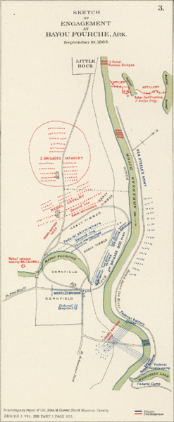
English: Plan of the battle of Corinth fought on the 3d and 4th of October,1862, between the Confederate forces under Major Generals Van Dorn, Price and Lovell and the United States forces under Major General Rosecrans. Accompanying official report respectfully forwarded (by) W.S. Rosecrans. (with) Map of the ground on which was fought the battle of Iuka, Miss. on the 19th of September 1862. (with) Sketch of engagement at Bayou Fourche, Ark. September 10, 1863 ... report of Col. John M. Glover ... (with) Sketch showing positions of pontoon bridges and guns covering them at Fredericksburg, Va., December 11-15, 1862 ... report of Lieut C.B. Comstock ... (with) Map showing the intrenchments around Wilmington. Surveyed and mapped under the direction of Capt. W.H. James ... by L.C. Turner, C.E., 1863 ... (with) Map of route followed by the Cavalry Division through Maryland into Pennsylvania under command of Maj. Gen. J.E.B. Stuart October 1862. Prepared by Wm. W. Blackford ... Julius Bien & Co., Lith., N.Y. (1891-1895) Author: Rosecrans, William S.; United States. War Department Higher-resolution version at the David Rumsey Historical Map Collection Bayou Forche |
| Date |
Date: 1895 |
| Source |
Transferred from en.wikipedia to Commons. |
| Author |
Author: Rosecrans, William S.; United States. War Department. The original uploader was Brian0918 at English Wikipedia. |
| Permission (Reusing this file) |
PD-USGOV-MILITARY-ARMY. |
Licensing[edit]
This file is a work of a U.S. Army soldier or employee, taken or made as part of that person's official duties. As a work of the U.S. federal government, it is in the public domain in the United States.
|
 |
|
This work is in the public domain in its country of origin and other countries and areas where the copyright term is the author's life plus 100 years or fewer. | |
| This file has been identified as being free of known restrictions under copyright law, including all related and neighboring rights. | |
Original upload log[edit]
The original description page was here. All following user names refer to en.wikipedia.
| Date/Time | Dimensions | User | Comment |
|---|---|---|---|
| 2005-01-23 05:28 | 800×1938× (1017353 bytes) | Brian0918 | Plan of the battle of Corinth fought on the 3d and 4th of October,1862, between the Confederate forces under Major Generals Van Dorn, Price and Lovell and the United States forces under Major General Rosecrans. Accompanying official report respectfully fo |
File history
Click on a date/time to view the file as it appeared at that time.
| Date/Time | Thumbnail | Dimensions | User | Comment | |
|---|---|---|---|---|---|
| current | 07:07, 21 May 2022 | 800 × 1,938 (994 KB) | BD2412 (talk | contribs) | Transferred from en.wikipedia via #commonshelper |
You cannot overwrite this file.
File usage on Commons
The following page uses this file:
File usage on other wikis
The following other wikis use this file:
- Usage on en.wikipedia.org